Transport Technical Paper [EXAM 114]
(10) 2. Key Concerns Raised by the Inspector
2.1.1 Paragraphs 41 to 48 of EXAM 69 raise concerns that additional, more detailed work to model M1 junction 13 was yet to be completed at the time of the hearing sessions, which could result in identifying alternative options for mitigation other than what had been tested. The Inspectors considered this work would form a critical piece of evidence that directly relates to the location of the Plan's largest allocation for up to 5,000 new homes at Marston Vale, and as such, that it would be necessary to consider the implications of this new evidence when it emerged and test it through further examination hearing sessions.
2.1.2 Additionally, EXAM 69 raises concerns around the cross-boundary impacts that have been identified in the M1, J13 area. In particular, the concern was raised at the hearings by participants about some of the detailed model output and statements referenced in the technical documents, including some clarity being required on what the strategic model was showing regarding the predicted traffic flows between the Marston Vale allocation (SA2) and Milton Keynes via the A421.
(9) 2.2 M1 Junction 13
2.2.1 As stated above, concerns were raised in relation to the timing of the additional modelling work that was commissioned by Highways England to understand the cumulative impact of future development on M1 J13.
Paragraph 46 of EXAM 69 states:
"Whilst the Council and Highways England consider that this work should not delay adoption of the Plan, it is clearly going to form a critical piece of evidence which directly relates to the location of the Plan's largest allocation for up to 5,000 new homes at Marston Vale. In order to reach a robust, substantiated conclusion on the soundness of the Plan it would be necessary to consider the implications of the new evidence when it emerges and test it through further examination hearing sessions."
2.2.2 In the Memorandum of Understanding (EXAM 15) signed between HE and CBC in July 2019, it is clear that both parties agreed that sufficient modelling had been undertaken to inform the Local Plan. Both parties acknowledged that further assessment of development impacts would be required at later stages, using additional tools such as junction modelling or micro-simulation, compatible with the developments planning application process.
2.2.3 As such, the Council does not agree that the additional Junction 13 modelling was necessary to reach a robust and substantiated conclusion on the soundness of the plan. This goes beyond what is generally required for plan-making purposes.
2.2.4 Notwithstanding this point, CBC have worked closely with HE to progress this modelling and to understand its conclusions.
2.2.5 In January 2020, HE appointed AECOM to appraise a set of potentially deliverable mitigation scenarios at M1 J13. The scenarios were investigated to determine if they could mitigate future capacity issues. The tests were undertaken for forecast years 2025 and 2035, using forecasting methods to determine the future operation of the junction under both a 'do minimum' scenario and a 'do something' scenario:
- Do minimum: a scenario with an updated network to replicate the anticipated future network following the completion of the A421 dualling and M1 J13 – J16 Smart Motorway 'all lane running' schemes.
- Do something: a scenario whereby in addition to the 'do minimum', Local Plan growth was added and various options for mitigation were tested.
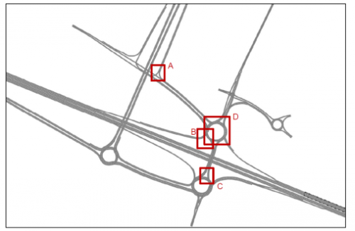
2.2.6 In total five potential intervention scenarios were tested, each of which are described below and presented in Figure 1:
Figure 1, Location of Intervention Tested
|
Scenario |
Description |
|
A |
Addition of a flare to the A421 southbound off-slip, which enables modifications to the off-slip approach lane allocation, allowing two full length left turn lanes. The two-lane left turn also requires an updated signal specification. |
|
B |
Signalise the M1 southbound off-slip approach to the roundabout and add a flare. The circulatory link is also signalised. |
|
C |
Widening the southbound overbridge at the approach to the southern roundabout. |
|
D |
A combination of multiple interventions which are as follows:
|
|
E |
Scenario E is the combination of the interventions in Scenario D and Scenario C: this scenario therefore includes all the interventions and their cumulative effects. |
2.2.7 The key conclusions made based on the modelling undertaken are as follows:
- The congestion on the M1 southbound off-slip, which impacts the operation of the M1 mainline is mitigated when controlled through signalisation of the approach the northern roundabout and the corresponding opposing circulatory. The signalisation of this approach also provides a benefit for the Salford Road eastbound approach/ A421 southbound off-slip, as it provides more gaps for the priority-controlled approach to the roundabout;
- The widening of the A421 southbound off-slip reduces queuing on that approach, but the benefit is limited by congestion downstream at the northern roundabout of Junction 13, especially in the PM peak hour;
- The M1 southbound on-slip and Bedford Road/ Salford Road junction are close to capacity and cannot cater for the additional traffic released by the interventions. Additional mitigation is therefore required at these bottlenecks to gain the benefits of the interventions tested;
- The widening of the approach from the southbound bridge (Scenario C) improves the operation of the southern roundabout.
2.2.8 The outcomes of the initial options modelled have shown that Scenarios B and C offer additional capacity without causing further congestion at other locations on the junction. The modelling has also showed that the junction is constrained due to traffic not being able to exit the junction on to the Salford Road and the M1 south bound on-slip.
2.2.9 This modelling work indicates that these two scenarios can deliver additional capacity sufficient to mitigate the impact of Local Plan growth. These measures are in addition to and complement the mitigation scheme for the Marston Gate allocation (Policy SE2).
2.2.10 HE has confirmed that the preferred combined scenarios (B&C) are likely to cost in the region of £4m to £5m. This cost aligns with the cost range given in CBC's original Strategic Transport Modelling for the mitigation identified, which was between £2.5m and £5m. The developers of Marston Valley have previously confirmed that the costs quoted in the Strategic Transport Modelling are viable. This remains the case.
2.2.11 The Council and HE have prepared an additional SoCG (Exam 111), which makes clear that both Highway Authorities are satisfied that the development being proposed in the Local Plan can be mitigated and what that mitigation should be.
(2) 2.3 Strategic Model Flow Outputs – A421 to Milton Keynes
2.3.1 During the Examination hearing sessions and the subsequent formal response from the Inspectors (EXAM 69), there was discussion and concern raised in relation to an interpretation of the detailed model output which was believed to indicate that relatively low numbers of cross boundary vehicle movements via the A421 towards Milton Keynes were being predicted by the CBC strategic model (CBLTM) as a result of the cumulative impact of Local Plan allocations in the area, namely the Marston Gate Strategic Employment site (Policy SE2) and Marston Vale New Villages (Policy SA2). This query was raised during Matter 13 on day 16 of the Local Plan Examination in Public (23rd July 2019).
The Inspectors have posed a specific question in paragraph 47 of EXAM 69, which states:
'…. we continue to have reservations about the cross-boundary impacts which have been identified. In particular, Examination Documents C24-C28 suggest that there will only be 'limited interactions' between the Marston Vale allocation and Milton Keynes via the A421, with less than 50 vehicle movements in the AM and PM peak. Although the Marston Vale allocation is intended to create new mixed-use development, and therefore reduce the need to travel, it is ideally placed for accessing Milton Keynes along the A421. In the context of an allocation for up to 5,000 new homes, we fail to see how the evidence is an accurate reflection of likely future transport patterns. If, as the Council suggests, motorists will choose other routes, such as Salford Road instead of the A421, then this needs to be justified, and the impacts tested.'
2.3.2 Firstly, it is important to confirm exactly which section of road (or 'link' in the CBLTM model) that the query addresses. The Examination documents ED C24-C28 make clear that this is the section or link of the A421 to the west of M1 junction 13. This section of road is currently being upgraded to dual carriageway, and along with the M1 is a main route to and from Milton Keynes from Central Bedfordshire.
2.3.3 In addition, the references in ED C24-C28 are to 'PCUs', rather than vehicles, and so it is helpful to clarify this distinction. A 'PCU' is a passenger car unit - the standard method of replicating different types of vehicles in transport models. For example, a 5-seater car would be replicated as 1 PCU, whereas a bus may be replicated as 2.5 PCUs, and a motorcycle as 0.4 PCUs.
2.3.4 The three scenarios that were tested by the model and are relevant to this note include:
- Base year (replicating the data collection year of 2016 for calibration and validation purposes)
- Reference case growth, including known and committed growth and infrastructure commitments to 2035 (i.e. the "base" onto which the Local Plan growth is added to allow a comparison)
- Local Plan growth (i.e. reference case plus all Local Plan allocations to 2035)
2.3.5 The figure that was focused on at the hearings, and in EXAM 69, we believe is a figure extracted from technical report ED C26, table 4.1, whereby the Marston Vale New Villages allocation was noted in the report to have 'limited interactions (<50 PCU in both peak hours) with Milton Keynes via the A421'.
2.3.6 Each strategic site allocation was tested in this way, and the figures that are presented are the net changes in values for the PCUs on that link in the model. This is the difference between the 'Actual' flow (being the quantum of traffic that the model forecasts is able to physically utilise the link during the modeled period) and the 'Demand' flow (being the quantum of traffic that the model forecasts would prefer to use this route, given no other impediments to accessing it caused for example, by congestion elsewhere in the model). The difference between these two figures is the figure that is reported i.e. the demand that is not able to be released to this part of the network, due to congestion or capacity issues, which is the case in the M1 J13 area. These reported figures relate to either the AM or PM peak hour, and not the full daily demand.
2.3.7 Therefore, the quoted figure does not represent the trip generation from the Marston Gate and Marston Vale developments specifically on this link. Rather, it suggests the volume of trips across the entire CBLTM model that may not be able to reach this link because they are constrained from doing so elsewhere in the model. In this context and bearing in mind the overall flow volumes occurring on routes such as the A421 and M1, a failure of 50 PCU's to reach this link would not be considered a significant failing in the model or its suggested performance of the network.
2.3.8 It is also relevant to consider what the model output is showing for this link in the base year of 2016, the future reference case and at the end of the Local Plan period. The CBLTM model can also show us demand flows on this link in more detail (i.e. the total demand created by the scenario and not the net flow as previously explained).
2.3.9 In the base year of 2016, modelled demand flows for the link in question there will be around 1,000 PCUs for each of the peak hours, on average, in each direction. In the reference case, this figure increases, due to the committed growth included in the twenty year period of the mode, to around 1,300 PCUs each way, and then in the Local Plan growth scenario it is marginally higher, at around 1,300 to 1,400 PCUs on average in each of the peak hours.
2.3.10 We are fortunate in respect of the Marston Gate and Marston Valley sites that we also now have more detailed information to compare with the CBLTM strategic model data. Both of these schemes are subject to live planning applications, and so have undertaken more detailed assessment of the effects of these schemes on the local highway network – including the A421.
2.3.11 The applicant for the Marston Valley development site modelled the impact of this growth in more detail, using a bespoke model. The Transport Assessment submitted (as part of the application), outlining the outputs from this model, suggests that the Marston Valley development would potentially generate a total demand on the A421 west of the M1 for some 262 PCUs in the morning peak period, and 107 PCUs in the evening peak period. This is helpful in understanding the possible impact that may occur. Through the planning application process, the applicant has also indicated that they have tested mitigation proposals that are able to offset the impacts of their additional traffic at M1 junction 13.
2.3.12 This detailed modelling also supports the strategic findings that trips associated with the Marston Valley site will also access the wider network, including towards Ampthill, Flitwick and Leighton Buzzard via the M1, A421, A507 and A4012. All of these routes have been assessed by the applicants, with mitigation measures being proposed as and where appropriate.
2.3.13 It should be noted that the CBLTM is a strategic area wide model, consistent with the requirement to evidence strategic growth proposals across Central Bedfordshire. For this reason, the model is strategic in nature and representation, zoning and network coverage. It would not be expected that the model would replicate every link in detail, as only the more significant routes are included in any event.
2.3.14 This is an accepted approach to wide area network modelling; indeed, it is the most commonly adopted practice where there is a significant level of growth that needs to be modelled. This method of modelling is widely used to evidence the strategic understanding of a Local Plan growth scheme.
(4) 2.4 J11a and M1-A6 Link Road
2.4.1 Since EXAM 69 was received by the Council, various communications have been provided to the Inspectors in relation to the M1-A6 Link Road, which seek to share the most up-to-date information (These are all available as Examination Documents).
2.4.2 The main, and material change, to the scheme's status is that on 9th January 2020, the Link Road was granted planning permission (under application reference CB/19/00887/FULL). This means that in accordance with guidance on Sustainability Appraisal (SA), it has now been treated as a commitment in terms of both the SA and the Local Plan. Consequently, concerns around its alignment have now been superseded.[1] However, it is clear that the Local Plan still needs to consider any proposed new allocations within this area. This is dealt with in the Housing and Employment Technical Papers (EXAM 113 and 112, respectively), which should be read alongside this paper.
2.4.3 Further evidence and information is now also available in respect of M1 Junction 11a (J11a). For the purposes of both the Business Case for the Link Road, and to ensure the Local Plan proposals can be appropriately mitigated, additional work has been undertaken to understand the mitigation that is required at this location.
2.4.4 At the time of the submission and initial consideration of the planning application referenced above, Highways England raised a holding direction indicating that a detailed mitigation scheme for M1 J11a would be required to confirm that this location could operate within capacity with the M1-A6 link road constructed and with the additional impact of CBC Local Plan growth, namely the North of Luton (Policy SA1) and Sundon RFI (Policy SE1) allocations. The link road would be the point of access for these allocations to join the strategic highway network at J11a, and as such it was important for HE to understand the operation of the junction in detail, also considering future growth.
The requirement is confirmed under condition 13 of the decision notice for the scheme:
'Prior to the commencement of the development, hereby approved, details of the proposed highways mitigation (including a phasing plan for the mitigation), associated with Junction 11a of the M1, shall be submitted for approval in writing. The development shall be constructed in accordance with the approved details. The approved mitigation shall be provided in accordance with an approved details.
2.4.5 Reason: In order to provide suitable level of access, with acceptable level of highways safety, in accordance with the NPPF, Policy BE within the adopted Local Plan and Policy HQ1 within the emerging Local Plan.'
2.4.6 This approval is stated as being required pre-commencement of the scheme and would exceed the usual requirements for Local Plan evidence, however it was considered important for Local Plan purposes to expedite this work in order for agreement to be reached that a suitable mitigation scheme was deliverable at this location, and that the costs of such a scheme were not unviable.
2.4.7 CBC and HE have been working in partnership to agree the detail of this mitigation and have confirmed through the additional SoCG (EXAM 111) that this work clearly demonstrates that mitigation is possible.
2.4.8 The proposed scheme at M1 J11a involves:
- The addition of new M1-A6 Link approach arm to the eastern dumbbell
- The widening of the eastern roundabout with the addition of an extra lane in between the southbound off-slip and the exit onto the M1-A6 link
- The addition of an extra lane to the western roundabout between the M1 northbound off-slip and the access from Woodside Link
- The elimination of the connector between the eastbound exit from, and the westbound entry to the western roundabout
- The extension of the flare on the M1 northbound off-slip approaching the western roundabout and
- The signalisation of the M1-A6 Link, M1 Northbound, Woodside Link and A5 West approaches, with associated signalisation of the opposing circulatory carriageway (Current signalisation of the M1 Southbound approach is retained).
(3) 2.5 Other Outstanding Issues
2.5.1 At the hearing sessions, CBC were reminded that they had committed to preparing a technical note on the Council's approach to sustainable travel, as identified in the Memorandum of Understanding (EXAM 7R) between CBC and HE. This has now been prepared, agreed by HE and can be found attached, as Appendix 1.
[1] A request for permission for a Judicial Review of this decision was filed, however the Council has now (4th May 2020) received notification that permission has been refused by the High Court.


