Central Bedfordshire Pre-submission Local Plan (January 2018)
7 Implementation
7.1 Delivery Rates
7.1.1 The delivery rates of existing housing commitments have already been determined and are set out within the housing trajectory in the Strategic Housing Land Availability Assessment (SHLAA). It is important that new allocations identified by this Local Plan contribute to delivering a continuous supply of housing throughout the plan period. It is therefore appropriate for the Council to use reasonable assumptions to determine the likely delivery of particular development sites taking into consideration competing sites, likely commencement, and any enabling works that need to be undertaken in advance of development.
7.1.2 This is particularly important for those key strategic sites which are critical to the delivery of this strategy. An indication of expected delivery rates is therefore set out below to ensure that this is managed effectively. The impact of phasing for strategic scale sites to allow for the delivery of enabling infrastructure often means that strategic sites deliver only a proportion of their total capacity within the plan period.
Table 7.1: Anticipated Delivery Rates of Strategic Sites
|
Year |
Dwelling numbers by Strategic Allocation |
|||
|
North of Luton |
Marston Vale |
East of Arlesey |
East of Biggleswade |
|
|
21/22 |
|
50 |
|
|
|
22/23 |
50 |
100 |
|
|
|
23/24 |
100 |
250 |
50 |
50 |
|
24/25 |
150 |
300 |
100 |
150 |
|
25/26 |
200 |
300 |
100 |
150 |
|
26/27 |
200 |
300 |
150 |
150 |
|
27/28 |
300 |
300 |
150 |
150 |
|
28/29 |
300 |
300 |
150 |
150 |
|
29/30 |
300 |
300 |
150 |
150 |
|
30/31 |
300 |
300 |
150 |
150 |
|
31/32 |
300 |
300 |
150 |
150 |
|
32/33 |
300 |
300 |
150 |
150 |
|
33/34 |
300 |
300 |
150 |
100 |
|
34/35 |
300 |
300 |
150 |
|
|
POST |
900 |
1300 |
400 |
0 |
7.2 Housing Supply
7.2.1 The Strategic Housing Land Availability Assessment (SHLAA) demonstrates that there are sufficient sites to ensure that the Local Plan meets the full objectively assessed need of 32,000 dwellings and 24,000 new jobs over the 2015-2035 plan period. This represents an average need of 1,600 dwellings and 1,200 jobs per year.
7.2.2 Local Planning Authorities are also required to 'identify and update annually a supply of specific deliverable sites sufficient to provide five years worth of housing against their requirements'. If this cannot be demonstrated a 'presumption in favour of sustainable development' is applied. It is therefore been vital that this Local Plan has allocated sufficient deliverable and developable land at range of scales and locations in order to ensure that a five year supply is maintained.
7.2.3 In order to demonstrate a five year supply of housing, significant and demonstrable site specific evidence must be produced. This council regularly contacts housebuilders to determine when their sites will be delivered and this information is added to the Housing Trajectory on a quarterly basis.
7.2.4 In addition to meeting Central Bedfordshire's housing need, the plan target also includes provision for 7350 homes to meet Luton's identified 'unmet need' as outlined in paragraph 6.2.1.
7.3 Monitoring
7.3.1 Annual housing completions and the supply of housing land will be rigorously monitored on at least an annual basis to determine if delivery requirements are being met and whether the five year supply of housing land is being maintained. The Housing Trajectory and statements on the five year housing land supply will be published within the annual Authority Monitoring Report (AMR) and on the Council's website.
7.3.2 In order to assess the application and effectiveness of all the policies in the Local Plan the Council a monitoring framework has been produced to support this Plan (Appendix 3). This lists all the policies and sets out how they will be monitored. The results of this monitoring will be published each year in the AMR. This will provide valuable evidence of any policy areas where the Council may need to take action.
7.4 The Key Diagram

7.5 Strategic Allocations: General requirements
7.5.1 Evidence has shown that the development of large scale new communities (of more than 1500 homes) which are well located for employment and services and have the potential to be well served by sustainable transport will be the most sustainable option for growth alongside development at different scales in proximity to existing settlements. Allocations for growth are set out in Policy SP1.
7.5.2 In order to inform the identification of the most appropriate and sustainable locations for growth within Central Bedfordshire, proposals for the delivery of these locations will be expected to demonstrate conformity with the strategic objectives, wider development principles and polices as set out within this plan. They should also meet the following generic requirements for strategic sites to ensure that good placemaking principles are embedded into new strategic developments as set out below. This is in addition to the site specific allocation policies that follow.
7.5.3 It is expected that promoters of allocated strategic sites will sign up to a Planning Performance Agreement (PPA) with the Council.
Policy SP3: Generic Requirements for Strategic Sites
Development proposals bought forward at the identified strategic allocations should be accompanied by comprehensive Development Brief for the whole site. Proposals should be based on the following requirements and objectives:
- Creation of distinctive, well integrated new communities which respect their local context, enhance the standards of sustainable design in the locality and relate well to neighbouring settlements;
- Preparation of a comprehensive masterplan for the whole site which includes an indicative layout and phasing plan. The masterplan should reflect the location of the site, incorporate the highest standards of design and make effective use of the site through application of appropriate densities, layout and form;
- Meeting the housing needs of all sectors of the community including families, the young and older people and to match house types to the local employment base in order to reduce the need for out commuting;
- Provision of a local centre for the new community, with a range of facilities to meet local needs including small-scale employment uses, pre-school facilities, and primary education, including provision for health and social care in the locality. Integrated Health and Care Hubs should be located in close proximity to schools and elderly persons accommodation and provided early in the development programme;
- Provision of a Sustainable Transport Strategy, fully integrated into the overall masterplan and demonstrating improved linkages to existing transport nodes e.g. mainline rail stations by sustainable means and how the development will reduce the need to travel by car. Measures to mitigate the traffic impacts of the proposed development on the strategic and local road networks together with footpaths, cycleways, bridleways, and green corridors should be included;
- Promoters should undertake a full Transport Assessment to ensure that the package of mitigation measures are incorporated into the scheme, including pedestrian and cycle links, a public transport strategy and any offsite contributions as deemed necessary;
- A Green Infrastructure Strategy which sets out measures to protect and enhance any environmentally sensitive areas within and around the site, avoid harmful impacts and mitigate the local and wider impacts of the development, including phasing of these measures and their long term management, and to maximise the opportunities presented by undevelopable land;
- Where appropriate, the development should provide a fully integrated Sustainable Drainage System to mitigate against any potential flood risk, apply a flood risk sequential approach to development across the site;
- Detailed viability information including an infrastructure phasing and delivery plan.
7.6 What are Integrated Health and Care Hubs?
- Integrated Health and Care Hubs will support the local ambition for access to modern, high quality and locality based health and care services. These Hubs will be aligned to key Spokes in our rural communities. Central Bedfordshire population distribution and its relation to secondary care providers makes it imperative that the importance of the Integrated Health and Care Hubs approach is sustained. Services need to be more accessible to people, especially in predominantly rural areas, and should meet the requirements for delivering health and care services to an expanding and ageing population
- More services will be accessible to people where they live, whilst also enhancing community based and out of hospital services. These Hubs are important in helping to meet the complex needs of an ageing and growing population, in a predominantly rural area without its own district general hospital
- The integrated Health and Care Hubs will be the main centres for providing proactive and preventative care, out of hospital services and care packages for people who are vulnerable or have complex care needs. These Hubs will help to reshape the primary model which delivers primary care at scale, addressing the issue of capacity in general practice and ensuring equitable and timely access to care
- A locality based integrated health and care hub approach improves cooperation and joined up working which improves the access and quality of care provision. It also leads to a reduction of inappropriate hospital admissions and importantly supports the vision for integrated primary and community services at scale as set out in the General Practice Forward View
- As a minimum, these Health and Care Hubs are expected to serve as a base for the multi-disciplinary teams (adults and children's) being established as part of the community services redesign programme, including general medical services where possible. The co-location of health and care teams in fit for purpose facilities is central to managing demand and ensuring the future sustainability of local health and care systems
- Each Integrated Health and Care Hub will provide local access to a range of general medical and nursing, therapy, specialist and social care services with supporting information and advice systems. The Health and Care Hubs may also develop a range of additional or enhanced services in line with the needs of the local community. Enhanced services might include;
- Extended GP services on a 7 day basis
- Enhanced services delivered by and across practices, e.g. minor injury and minor illness services, clinics to support patients with long-term conditions
- Face-to-face out of hours consultations
- Community pharmacy
- Rehabilitation and re-enablement facilities
- Outreach services from local acute hospitals and specialist services, e.g. outpatient appointments and other specialist consultations
- Less complex diagnostics
- Public Health and prevention services, e.g. smoking cessation, NHS Health Checks, lifestyle hubs
7.7 Site Specific Allocation Policies
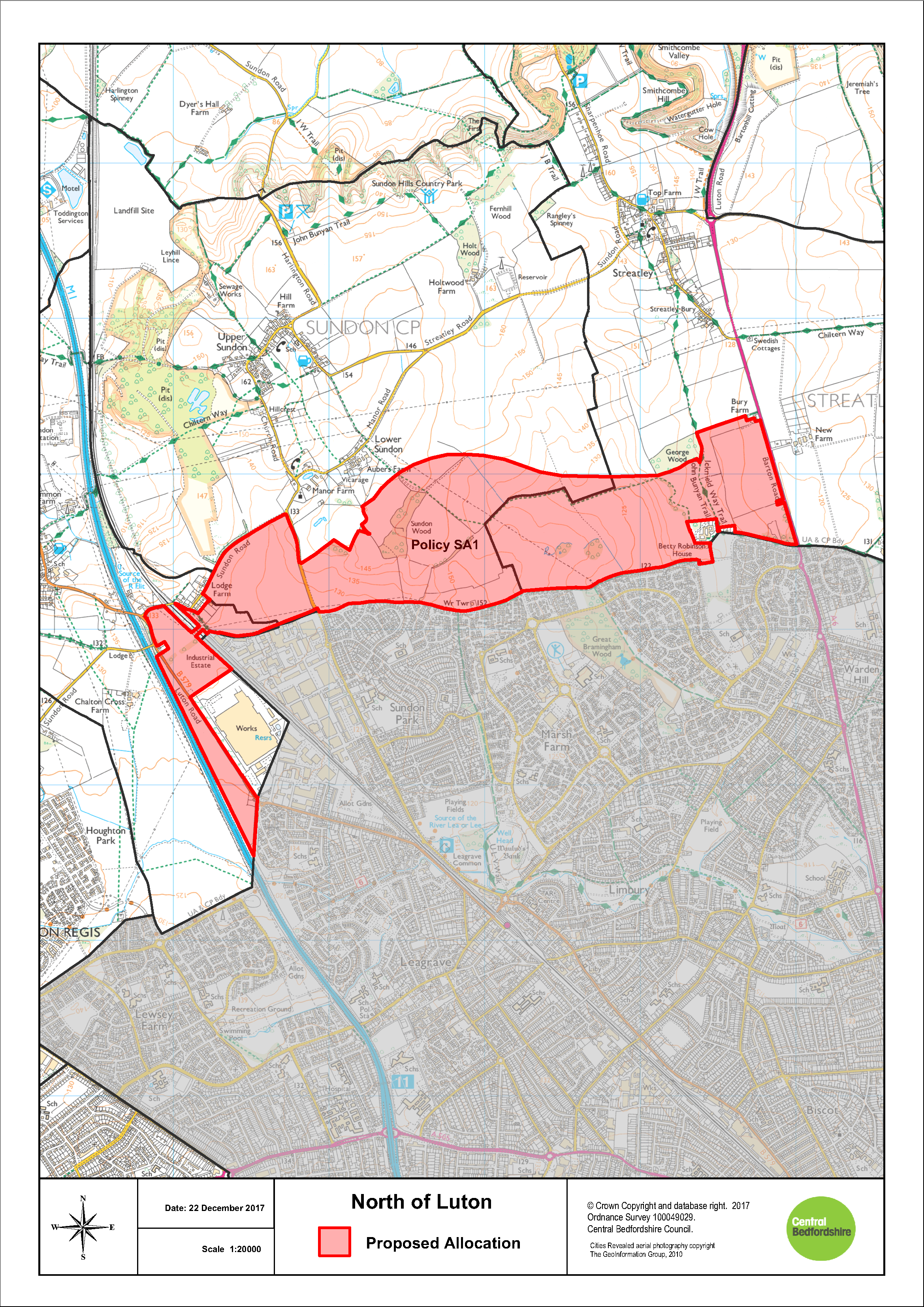
Policy SA1: North of Luton
Land to the north of Luton as identified on the Proposal Maps, is allocated for a mixed-use development consisting of up to 4000 dwellings and a minimum of 20 hectares of employment land for B1, B2 and B8 uses.
Development in the Strategic Land Allocation will be permitted in accordance with other relevant policies in the Development Plan and the principles set out below. These principles will be defined in more detail through the preparation of a Development Brief which will include a phasing plan. Planning permission will only be granted for development following the Council's adoption of this Development Brief. Design codes will also be required for each phase, to be prepared by the developer and approved by the Council.
In order to ensure the development will be supported by the local and strategic infrastructure needed to ensure sustainable development, in the context of pooling restrictions and multiple landownerships, the Council will refuse any piecemeal planning permission that would undermine the Councils ability to deliver the required infrastructure.
The principles of the development are:
- The development will form a well designed sustainable
urban extension to Luton that will provide a mix of uses
necessary to achieve a sustainable and vibrant community,
including:
- in the region of 4000 homes with an appropriate balance and mix of residential accommodation to meet identified needs, which shall include subject to viability, a policy compliant mix of affordable housing, starter homes, self/custom build plots and a mix of homes to meet all identified needs for older people;
- a minimum of 20 hectares of employment land, focused primarily to the west of the allocation site and centred around the new M1 Junction 11a to maximise access to the M1 and create an employment hub that compliments the new employment uses at North Houghton Regis;
- provide the serviced land necessary to deliver a health and social care hub within the site to serve the health and social care needs of the proposed development and the needs of the catchment area of that facility and a commensurate financial contribution towards the delivery of that facility;
- provision of new community facilities in accordance with Policy HQ2 including a mix of retail and at least one drinking establishment to serve the existing and new communities everyday needs;
- provision of new educational facilities, comprising day nurseries, early years, primary, secondary and sixth form facilities to meet the identified needs of the development or equivalent facilities to meet the educational and childcare needs arising from the development; and
- provision of leisure facilities, including:
- indoor sport and leisure facilities, in accordance with Policy HQ3; and
- outdoor sport, leisure and open space, in accordance with Policies EE12, including pavilions and allotments
- It is critical that development of this site is supported by a comprehensive scheme of highway improvements to mitigate the impacts of the development including an appropriately designed a routed new road to link the A6-M1 Junction 11a, the development shall provide the land and commensurate financial contributions towards its delivery.
- The development will be phased in accordance with the timing of supporting infrastructure and community facilities including the delivery of the Link road, which shall be delivered as soon as viably possible. The phasing of the road will commence from the west, with the first phase a dual carriageway between M1 Junction 11a and Sundon Park Road to facilitate access to the first phase of development and Sundon RFI employment allocation;
- The development will provide other supporting transport infrastructure, including proposals to mitigate the impact of traffic associated with the development, including providing for efficient public transport routes through the development that link with key destinations including Leagrave Train Station and Luton town centre;
- The development shall Integrate and connect to existing public rights of way within and adjoining the site to provide routes to the wider countryside and neighbouring settlements. The development shall include a cycleway connection to route 6 of the national cycleway network and will be required to provide new crossings on the A6 and crossings over the new link road to improve and maintain connections; it is essential that the development contributes towards the delivery of and is served by an appropriately designed and routed new link road between the A6 and M1 Junction 11a;
- The development shall provide dedicated and safe pedestrian and cycle links from the new and existing neighbourhoods to local centres, employment opportunities, schools, shops and community facilities; both within the allocation and the wider Luton conurbation;
- The development shall maximise opportunities to create Green Infrastructure corridors through the site linking with existing Green Infrastructure assets, including a link between Bramingham Park and George Wood; and a link between Bramingham Wood and Sundon Wood, beneath the current alignment of the pylon lines. The development shall also provide a green corridor along key routes including the setting of the Theedway and appropriately designed Green Infrastructure to mitigate visual impacts upon the setting of the AONB and the significance of heritage assets;
- The development shall provide appropriate mitigation,
compensation and/or enhancement of key features of
biodiversity, to ensure a net gain for biodiversity
including but not limited to;
- Sundon Wood CWS, Bramingham Wood CWS, Sunshine Riding Stables CWS, Sundon Quarry SSSI and CWS, Galley and Warden Hills SSSI and CWS, Sundon Country Park CWS and Barton Hills National Nature Reserve SSSI; and
- Identified protected species and priority habitats;
- The development shall ensure that the design and construction of the development as a whole including the A6 to M1 junction 11a link road has no undue impact on the AONB, heritage assets and biodiversity and provides for the mitigation and enhancements where feasible. With the exception of the link road any major built development within the AONB shall require exceptional circumstances to be demonstrated and shall only be permitted where it can be demonstrated it is in the public interest;
- The development will ensure that any impact on non designated heritage assets with archaeological interest is mitigated in order to record and advance understanding of any heritage assets affected by the development. The mitigation will include making the results of all archaeological investigations publically available for the benefit for this and future generations
- The development will be designed to mitigate any harm caused to the significance of all designated heritage assets within the site boundary and the setting of all designated heritage assets which lie within the site's vicinity. The development will not result in the destruction of any designated heritage assets or their settings and shall deliver mitigation measures that preserve all designated heritage assets and their settings for future generations. This is required in order to ensure that the public benefits of the development outweigh the degree of harm caused to the significance of all designated heritage assets affected by the development
- Subject to the findings of the site specific flood risk assessment the development shall deliver strategic measures to reduce flood risk including the use of sustainable drainage methods (SUDS) to attenuate and discharge surface water run-off at reduced rates, and at least at a rate no greater than if the site were undeveloped and to reduce existing downstream risk. This may include consideration of "off-site" solutions. The development and strategic measures will be designed to ensure there no detrimental impact on groundwater flooding downstream and shall seek to intercept and store surface water flows on site. Regard shall be had to the phased delivery of flood mitigation and SUDS in accordance with the phasing of the development to ensure adequate measures to reduce flood risk (from all sources) are provided throughout the lifetime of the development. The detailed designs of sustainable drainage systems maximise biodiversity enhancement, mitigation of visual landscape impacts, maintenance and safety, when considering their location and relationship to neighbouring uses. Safe access and egress shall be provided taking account of the flood risk at the site
- The development shall be connected to the mains sewerage network and any application for planning permission shall detail any infrastructure upgrades where required and any necessary phasing arrangements;
- The development shall provide appropriate landscaping measures to create a sense of place, provide a net gain for biodiversity and shall mitigate the potential impact of development on the wider landscape including the AONB. To mitigate harm to the AONB the development shall provide significant landscape enhancements on and beyond the northern allocation boundary and shall create a long term defensible Green Belt boundary as informed by detailed assessments. Noise attenuation fencing to mitigate noise impacts from the new link road will be resisted
- Incorporate measures to adapt to climate change, minimise energy use and include renewable energy technologies
The revised Green Belt boundary follows the extent of the allocation boundary.
SA1: North of Luton
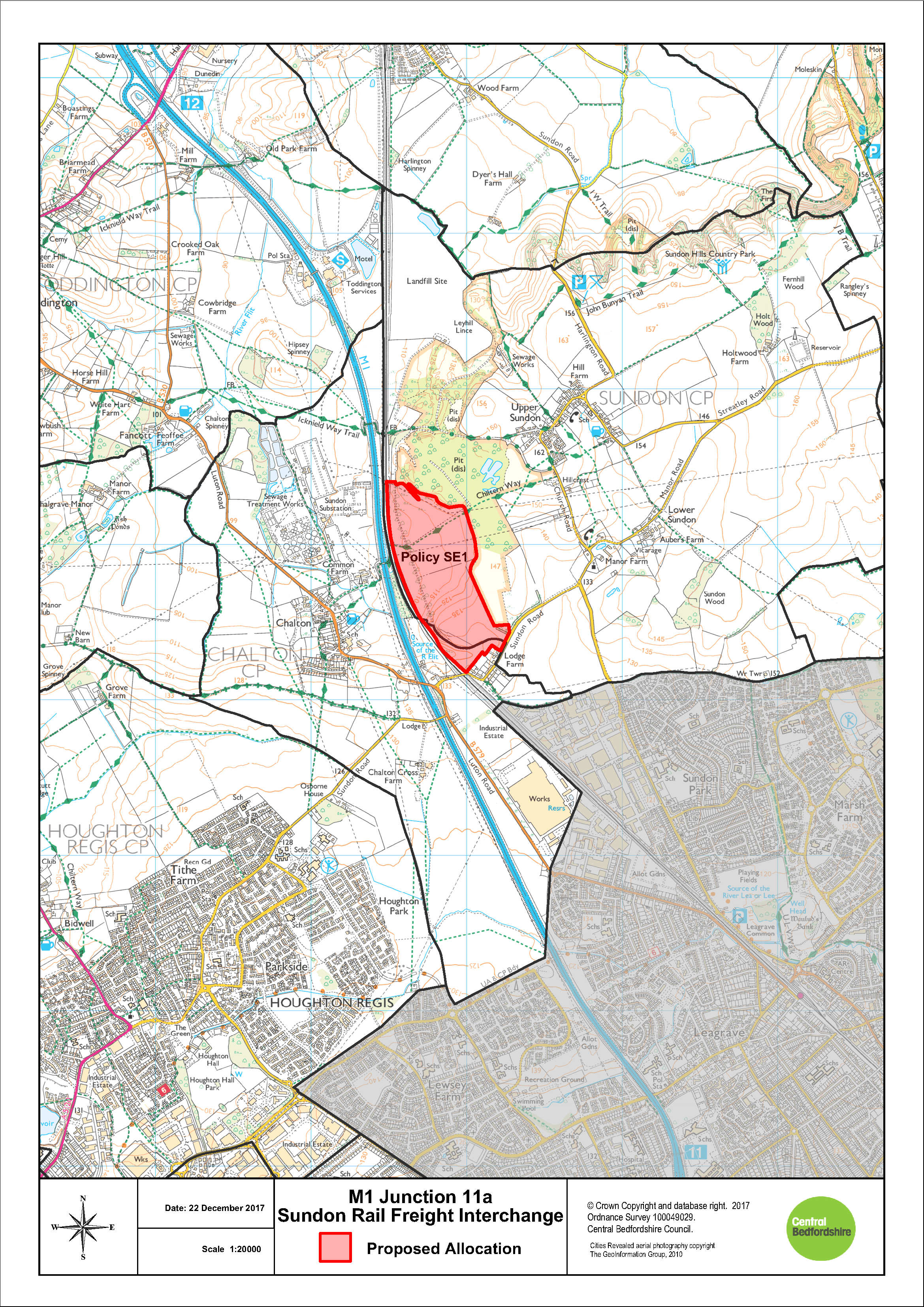
Policy SE1: M1 Junction 11a – Sundon Rail Freight Interchange (RFI)
The Sundon RFI as identified on the Proposal Map, will:
- provide an intermodal rail facility on approximately 5 hectares of the site;
- provide for approximately 40 hectares of new employment land accommodating B8 warehousing and distribution uses;
- be connected by an appropriate new strategic road link between Sundon Park Road and M1 Junction 11a;
- enhance and manage Sundon Chalk Pits CWS and Sundon Chalk Quarry SSSI to improve their ecological value and contribute to the GI network;
- preserve and enhance heritage assets within and around the site; and
- provide opportunities for sustainable transport links to be determined through a Transport Assessment.
Development will be permitted in accordance with other relevant policies in the Development Plan and following the successful preparation of a Master plan.
The on-site rail infrastructure and operational intermodal terminal should be constructed during the first phase of development.
The Green Belt boundary follows the extent of the RFI and employment allocation. The CWS and SSSI will remain in the Green Belt.
SE1: MI Junction 11a Sundon Rail Freight Interchange
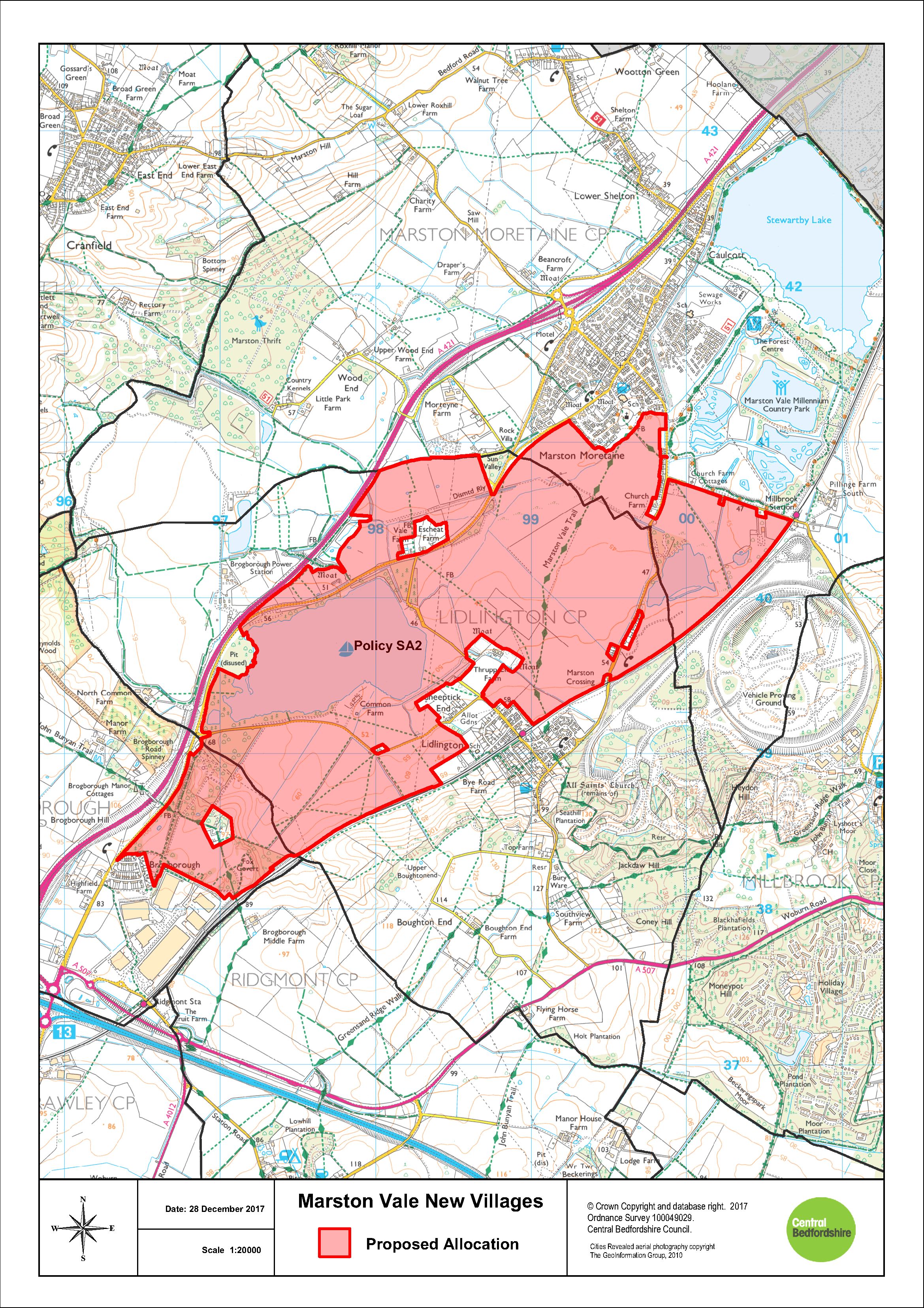
Policy SA2: Marston Vale New Villages
The land for Marston Vale New Villages, as identified in the Proposal Maps, is allocated for a mixed-use development comprising of up to 5,000 dwellings and a minimum of 40 hectares of employment land. The employment land is intended for B1, B2 and B8 uses, specifically for employment relating to research and development, office, distribution, services and tourism.
Development in the Strategic Land Allocation will be permitted in accordance with other relevant policies in the Development Plan and the principles set out below. These principles will be defined in more detail through the preparation of a Development Brief which will include a phasing plan. Planning permission will only be granted for development following the Council's adoption of this Development Brief. Design codes will also be required for each phase, to be prepared by the developer and approved by the Council.
In order to ensure the development will be supported by the local and strategic infrastructure needed to ensure sustainable development, in the context of pooling restrictions and multiple landownerships, the Council will refuse any piecemeal planning permission that would undermine the Councils ability to deliver such infrastructure.
The principles of the development are:
- The development will form a series of up to four new
villages separated and screened from neighbouring
settlements by appropriate green and blue infrastructure.
The villages will provide a mix of uses necessary to
achieve sustainable and vibrant network of communities.
Development will include:
- Approximately 5,000 homes across a series of up to four new villages with an appropriate balance and mix of residential accommodation to meet identified needs. This mix shall include, subject to viability, a policy compliant mix of affordable housing, starter homes, self/custom build plots and a mix of homes to meet all identified needs for older people;
- A minimum of 40 hectares of employment land, to satisfy identified needs for Research and Development, office, distribution, services and tourism. This employment should be well-integrated with the villages, both in terms of design and pedestrian and cycle access.
- provide a suitable parcel of serviced land and commensurate financial contributions towards the delivery of a primary healthcare facility to be delivered on site and the provision of a commensurate financial contribution towards the delivery of a health and social care facility to serve the healthcare needs of the development;
- Provision of new community facilities in accordance with Policy HQ2, including a mix of retail, a community library space and at least one drinking establishment to serve the existing and new communities everyday needs;
- Provision of new educational facilities, comprising day nursery facilities, early years, lower, middle, upper and sixth form facilities to meet the identified needs of the development or equivalent facilities to meet the educationsal and childcare needs arising form the development; and
- provision of leisure facilities, including:
- indoor sport and leisure facilities, in accordance with Policy HQ3; and
- outdoor sport, leisure and open space, in accordance with Policies EE12, including pavilions and allotments
- The development shall provide dedicated and safe pedestrian and cycle links between the new and existing villages, local centres, employment opportunities, schools, shops, public transport nodes and community facilities within the wider Marston Vale
- The development shall maximise opportunities to create Green Infrastructure corridors. The allocation is expected to deliver a multi-functional Green Corridor through the entire length of the site to form the Bedford and Milton Keynes Waterway Park. The development will deliver a water-filled and navigable link connecting Brogborough and Stewartby Lakes and shall deliver a cycleway from Stewartby Lake to Ridgmont Railway Station following the route of the Green Corridor
- The development shall provide appropriate mitigation, compensation and/or enhancement of key features of biodiversity including but not limited to, identified protected species and priority habitats. Existing ecological features should be well buffered and connected with additional habitat creation and linkages. Open water habitats in derelict brick pits provide valuable habitats for GCN, potential detrimental impacts on wet habitats must be avoided through careful zoning of uses
- The development shall provide appropriate landscaping measures to create a sense of place, provide a net gain for biodiversity and shall mitigate the potential impact of development on the wider landscape. The site is within the Forest of Marston Vale, and therefore any development must provide a total of 30% tree cover
- The development will ensure that any impact on non designated heritage assets with archaeological interest is mitigated in order to record and advance understanding of any heritage assets affected by the development. The mitigation will include making the results of all archaeological investigations publically available for the benefit for this and future generations;
- The development will be designed to mitigate any harm caused to the significance of all designated heritage assets in the vicinity of the site. The development will not result in the destruction of any designated heritage assets or their settings and shall deliver mitigation measures that preserve all designated heritage assets and their settings for future generations. This is required in order to ensure that the public benefits of the development outweigh the degree of harm caused to the significance of all designated heritage assets affected by the development;
- The development shall be designed to ensure that uses and developments within the site that are vulnerable to flood risk are located outside of areas of flood zones 2 and 3 and areas at high risk of surface water flooding. Flood capacity shall be retained on site.
- The development will, through the creation of the Bedford and Milton Keynes Waterway Park, provide a link for moving water between Brogborough and Stewartby Lakes, to increase the strategic flood storage capacity across the Marston Vale
- Subject to the findings of the site specific flood risk assessment the development shall deliver strategic measures to reduce flood risk including the use of sustainable drainage methods (SUDS) to attenuate and discharge surface water run-off at reduced levels where possible, and at least at a rate no greater than if the site were undeveloped and to reduce existing downstream risk. Regard shall be had to the phased delivery of flood mitigation and SUDS in accordance with the phasing of the development to ensure adequate measures to mitigate flood risk (from all sources) are provided throughout the lifetime of the development. The detailed designs of sustainable drainage systems should maximise biodiversity enhancement, mitigation of visual landscape impacts, flood risk reduction, maintenance and safety, when considering their location and relationship to neighbouring sites and uses. SuDS will be designed as part of the green infrastructure network, enhancing existing watercourses and drainage features, and integrating then with the Bedford and Milton Keynes Waterway Park. Safe access and egress shall be provided taking account of the flood risk at the site
- The development shall integrate and connect to existing public rights of way within and adjoining the site to provide routes to the wider countryside and neighbouring settlements, including a cycleway between Stewartby Lake and Ridgmont Railway Station which shall include appropriately designed crossings over the waterway
- The development will provide supporting transport infrastructure to mitigate the impact of traffic associated with the development, including commensurate financial contributions towards a deliverable scheme for improvements at J13 of the M1 and the Marsh Leys roundabout, to mitigate the impacts of development. The development shall deliver viable and efficient public transport routes through the development that link with key destinations including East West Rail at Ridgmont Train Station and employment areas
- The development shall provide commensurate contributions towards enhancing the infrastructure at Ridgmont Railway Station, including Public Transport interchange facilities and car parking;
- Foul drainage from the development will be connected to the public sewerage network. The development shall demonstrate that there is adequate capacity in water recycling centre (sewage treatment works) and the foul sewerage network to serve the proposed development and that it will not have an adverse impact on surface or ground water in terms of quality and quantity. Any application for planning permission shall detail any infrastructure upgrades where required and any necessary phasing arrangements as agreed by the relevant Water and Sewerage Company;
- Incorporate measures to adapt to climate change, minimise energy use and include renewable energy technologies.
SA2: Marston Vale New Villages
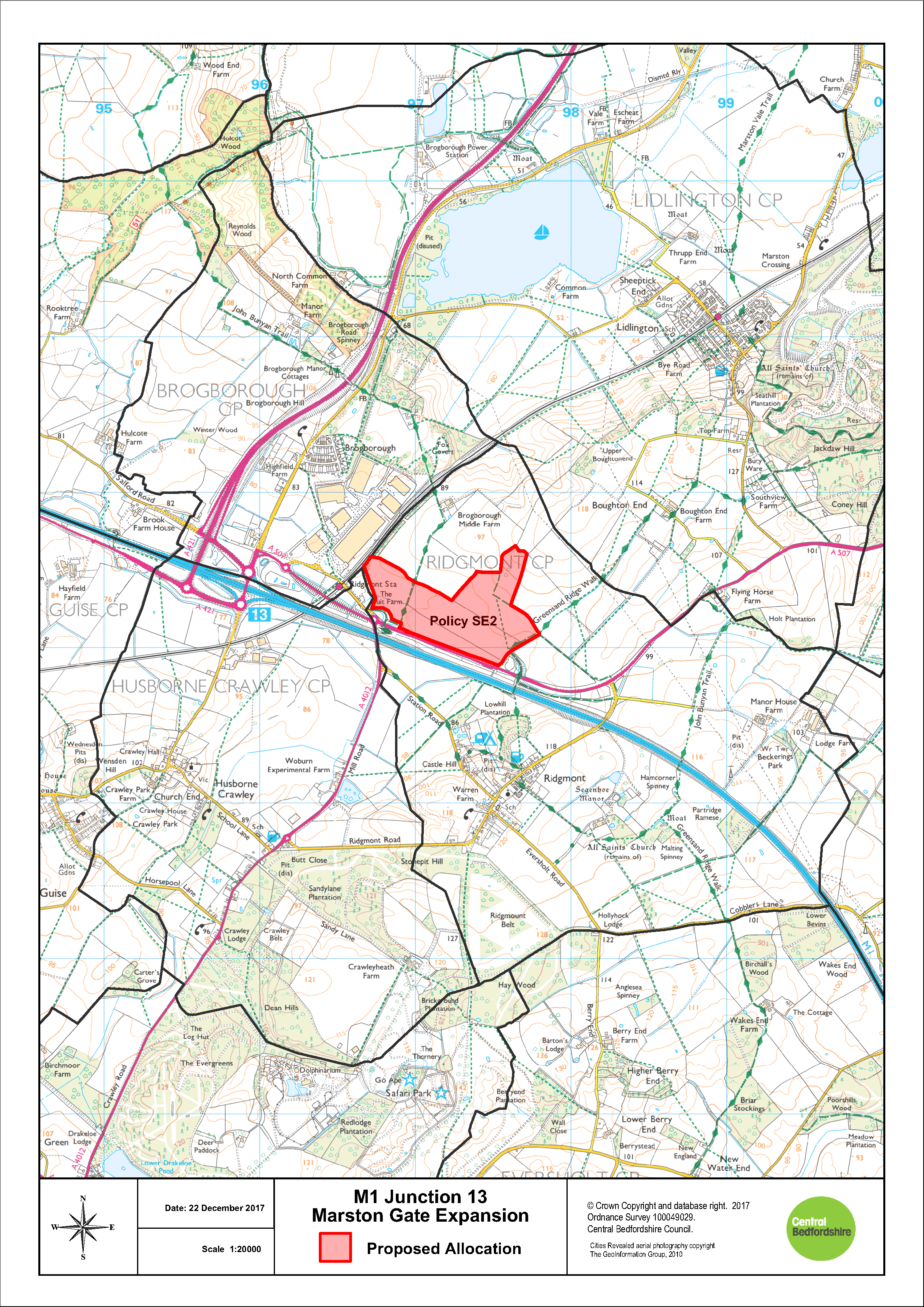
Policy SE2: M1 Junction 13 – Marston Gate Expansion
The Marston Gate Expansion, as identified on the Proposal Map, will:
- provide up to 35 hectares of new employment land and 8ha of screening and landscaping;
- deliver a mix of uses including B8 warehousing and distribution with associated B1 uses, A3 food and drink uses and a lorry park;
- facilitate necessary mitigation and improvements to the A507 and M1, including M1 Junction 13, to ensure the site is well connected to the strategic transport network; and
- provide opportunities for sustainable transport links to be determined through a Transport Assessment
Development will be permitted in accordance with other relevant policies in the Development Plan and following the successful preparation of a Masterplan which provides and exemplar design response to this unique gateway location.
Appropriate measures should be taken to ensure the proposals take full account of the potential arising from improvements to Ridgmont rail station to maximise sustainability and sustainable transport options.
SE2: M1 Junction 13 Marston Gate Expansion
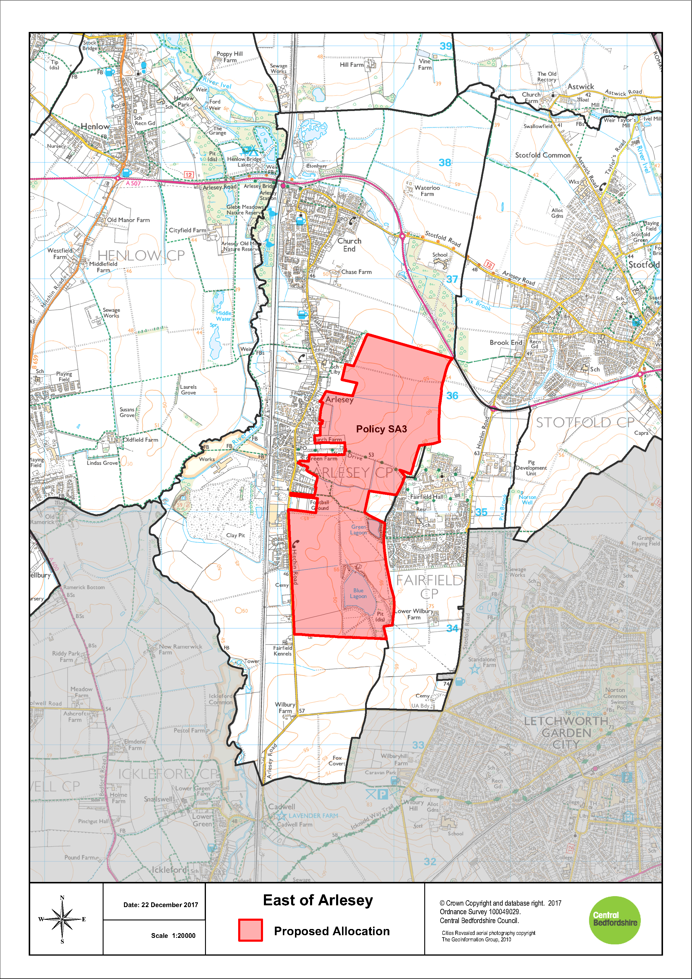
Policy SA3: East of Arlesey
Land to the east of Arlesey as identified on the Proposal Maps, is allocated for a housing-led development consisting of up to 2000 dwellings and a country park.
Development in the Strategic Land Allocation will be permitted in accordance with other relevant policies in the Development Plan and the principles set out below. These principles will be defined in more detail through the preparation of a Development Brief which will include a phasing plan. Planning permission will only be granted for development following the Council's adoption of this Development Brief. Design codes will also be required for each phase, to be prepared by the developer and approved by the Council.
In order to ensure the development will be supported by the local and strategic infrastructure needed to ensure sustainable development, in the context of pooling restrictions and multiple landownerships, the Council will refuse any piecemeal planning permission that would undermine the Councils ability to deliver such infrastructure.
The principles of the development are:
- The development will form a well designed sustainable
urban extension to Arlesey that will provide a mix of uses
necessary to achieve a sustainable and vibrant community,
including:
- in the region of 2000 homes with an appropriate balance and mix of residential accommodation to meet identified needs, which shall include subject to viability, a policy compliant mix of affordable housing, starter homes, self/custom build plots and a mix of homes to meet all identified needs for older people;
- a country park on the eastern edge of the development to retain an appropriate separation between Arlesey and Fairfield Park and to provide a net gain in green infrastructure and biodiversity;
- provide the serviced land necessary to deliver a health care facility within the site to serve the health needs of the proposed development and the needs of the catchment area of that facility and a commensurate financial contribution towards the delivery of that facility;
- provision of new community facilities in accordance with Policy HQ2 including community centres, a mix of retail and at least one drinking establishment to serve the existing and new communities everyday needs;
- Educational facilities, comprising day nurseries, early years, new school(s) for primary aged children to meet the identified needs of the development (or equivalent facilities to meet the educational and childcare needs arising from the development) and financial contributions towards the provision, improvement, enlargement or enhancement of schools for secondary aged children and sixth form facilities off site to meet the identified needs of the development (or equivalent contributions towards projects to meet the educational needs arising from the development); and
- provision of leisure facilities, including:
- indoor sport and leisure facilities, in accordance with Policy HQ3; and
- outdoor sport, leisure and open space, in accordance with Policies EE12, including pavilions and allotments
- The development shall provide dedicated and safe pedestrian and cycle links from the new and existing neighbourhoods to local centres, country park, Arlesey train station, employment opportunities, schools, shops and community facilities; both within the allocation and the wider Arlesey and Fairfield area
- The development shall maximise opportunities to create Green Infrastructure corridors and meet the aims and objectives of the Etonbury Green Wheel. This will be achieved through linking the proposed country park on the eastern edge with existing Green Infrastructure assets in Arlesey and Fairfield Park, including a link with Etonbury Woods; and improving the ecological and biodiversity gains at Blue and Green Lagoon
- The development shall provide appropriate mitigation,
compensation and/or enhancement of key features of
biodiversity including but not limited to;
- Blue Lagoon and Green Lagoon; and
- Identified protected species and priority habitats.
- The development will ensure that any impact on non designated heritage assets with archaeological interest is mitigated in order to record and advance understanding of any heritage assets affected by the development. The mitigation will include making the results of all archaeological investigations publically available for the benefit for this and future generations;
- The development will be designed to mitigate any harm caused to the significance of all designated heritage assets in the vicinity of the site. This is required in order to ensure that the public benefits of the development outweigh the any harm caused to the significance of all designated heritage assets affected by the development;
- The development shall be designed to preserve all designated heritage assets within the site and shall seek to mitigate the degree of harm to the significance of all designated heritage assets and shall deliver where necessary, relevant and reasonable measures to preserve those assets and their settings for future generations, to ensure the public benefits of development would outweigh the degree of harm to the significance of designated heritage assets
- The development shall consider the risk of flooding from ordinary watercourses and surface water and shall avoid vulnerable development in these areas accordingly. Subject to the findings of the site specific flood risk assessment the development shall deliver strategic measures to reduce flood risk including the use of sustainable drainage methods (SUDS) to attenuate and discharge surface water run-off at reduced rates, and at least at a rate no greater than if the site were undeveloped and to reduce existing downstream risk. This will include consideration of "off-site" solutions on the Pix Brook and River Hiz. The flood risk assessment will consider where surface water from the development will be discharged, in relation to existing flood risks and flood history on the Pix Brook and River Hiz. Regard shall be had to the phased delivery of flood mitigation and SUDS in accordance with the phasing of the development to ensure adequate measures to reduce flood risk (from all sources) are provided throughout the lifetime of the development. The detailed designs of sustainable drainage systems should maximise biodiversity enhancement, mitigation of visual landscape impacts, maintenance and safety, when considering their location and relationship to neighbouring uses. Safe access and egress shall be provided taking account of the flood risk at the site
- The development shall integrate and connect to existing public rights of way within and adjoining the site to provide routes to the wider countryside and neighbouring settlements. Existing rights of way within the site will be upgraded and new cycleways and pedestrian routes will be created to Arlesey Train Station in the north, in addition to improving connections between the development site, the emerging Arlesey Cross development and surrounding settlements
- It is essential that the development provides an appropriately designed Relief Road to connect the area from the south of Hitchin Road to the A507/High Street Link road in the north being proposed as part of Arlesey Cross. This will allow for access directly onto the A507 relieving congestion along the High Street in Arlesey
- It is essential that the development integrates and connects to the existing road network in Arlesey to allow for permeability and legibility between the new development and Arlesey
- The development will be phased in accordance with the timing of supporting infrastructure and community facilities including the delivery of the Relief road, which shall be delivered as soon as viably possible
- The development will provide other supporting transport infrastructure, including proposals to mitigate the impact of traffic associated with the development, including providing for efficient public transport routes through the development that link with key destinations including Arlesey Train Station
- Foul drainage from the development will be connected to the public sewerage network. The development shall demonstrate that there is adequate capacity in water recycling centre (sewage treatment works) and the foul sewerage network to serve the proposed development and that it will not have an adverse impact on surface or ground water in terms of quality and quantity. And any application for planning permission shall detail any infrastructure upgrades where required and any necessary phasing arrangements as agreed by the relevant Water and Sewerage Company
- The development shall provide appropriate landscaping measures to create a sense of place, provide a net gain for biodiversity and shall mitigate the potential impact of development on a predominately agricultural landscape. To mitigate harm a country park will be located on the eastern edge of the development to prevent coalescence and to create a defensible boundary between Arlesey and Fairfield Park
- Incorporate measures to adapt to climate change, minimise energy use and include renewable energy technologies
SA3: East of Arlesey
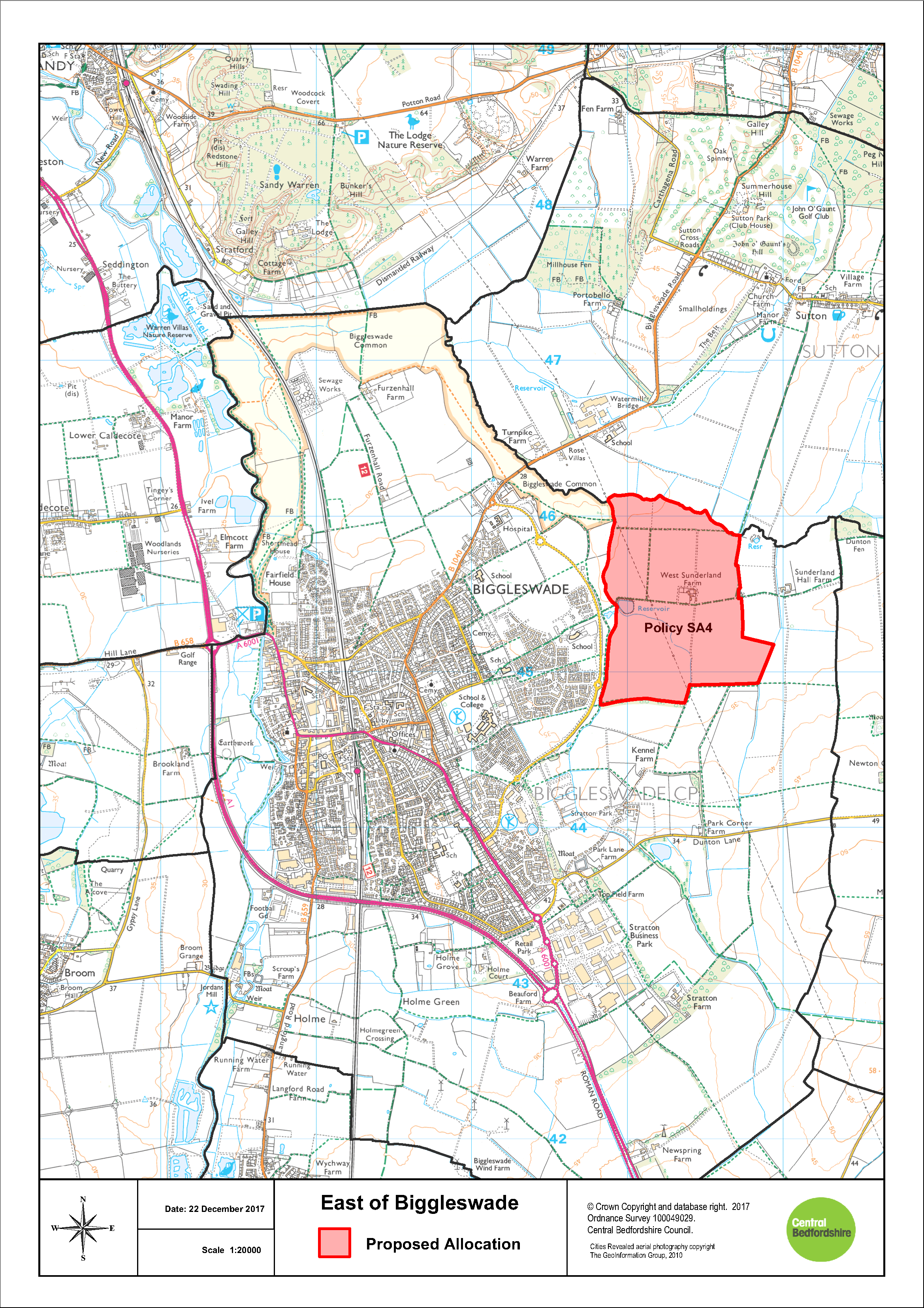
Policy SA4: East of Biggleswade
Land to the East of Baden Powell Way as identified on the Proposal Maps, is allocated for a mixed-use development consisting of up to 1500 dwellings and associated uses.
Development in the Strategic Land Allocation will be permitted in accordance with other relevant olicies in the Development Plan and the principles set out below. These principles will be defined in more detail through the preparation of a Development Brief which will include a phasing plan. Planning permission will only be granted for development following the Council's adoption of this Development Brief. Design codes will also be required for each phase, to be prepared by the developer and approved by the Council.
In order to ensure the development will be supported by the local and strategic infrastructure needed to ensure sustainable development, in the context of pooling restrictions and multiple landownerships, the Council will refuse any piecemeal planning permission that would undermine the Councils ability to deliver such infrastructure.
The principles of the development are:
- The development will form a well designed sustainable
village that will be visibly and physically separate from
Biggleswade and will provide a mix of uses necessary to
achieve a sustainable and vibrant community, including:
- in the region of 1500 homes with an appropriate balance and mix of residential accommodation to meet identified needs, which shall include subject to viability, a policy compliant mix of affordable housing, starter homes, self/custom build plots and a mix of homes to meet all identified needs for older people;
- provide a commensurate financial contribution towards the delivery of a health and social care hub to serve the health and social care needs of the development;
- provision of new community facilities in accordance with Policy HQ2 including a mix of retail and at least one drinking establishment to serve the existing and new communities everyday needs;
- educational facilities, comprising day nurseries, early years, new school(s) for primary aged children to meet the identified needs of the development (or equivalent facilities to meet the educational and childcare needs arising from the development) and financial contributions towards the provision, improvement, enlargement or enhancement of schools for secondary aged children and sixth form facilities off site to meet the identified needs of the development (or equivalent contributions towards projects to meet the educational needs arising from the development and
- provision of leisure facilities, including:
- indoor sport and leisure facilities, in accordance with Policy HQ3; and
- outdoor sport, leisure and open space, in accordance with Policies EE12, including pavilions and allotments
- The development will provide dedicated and safe pedestrian and cycle links from the new and existing neighbourhoods to local centres, employment opportunities, schools, shops and community facilities; both within the allocation and the wider area
- The development will maximise opportunities to create
multi functional Green Infrastructure, including:
- a parkland corridor to the west of the site to achieve the objectives of the Biggleswade Green Wheel and the provision of public open space as an extension to the Biggleswade Common. This Green Corridor will be of a scale commensurate to the Biggleswade Common with substantial wet woodland planting, rough grassland and scrub, complimentary to Biggleswade Common whilst providing significant mitigation to the inter-visibility between the built development within the allocation site and Biggleswade;
- landscaping and habitat linkages following the northern boundary of the site allocation, extending from the boundary of the site adjoining Biggleswade Common and towards Dunton Fen as well as substantial soft landscaping to be provided along the eastern and southern boundaries of the site to mitigate visual impacts on the landscape and the setting of heritage assets;
- The development will provide appropriate mitigation, compensation and/or enhancement of key features of biodiversity including but not limited to, Identified protected species and priority habitats;
- The development will ensure that the design and construction of the development as a whole has no undue impact on the landscape, and biodiversity and provides for the mitigation and enhancements where feasible;
- The development will ensure that any impact on non designated heritage assets with archaeological interest is mitigated. The mitigation will include making the results of all archaeological investigations publically available in order to record and advance understanding of any heritage assets affected by the development for benefit for this and future generations;
- The development will be designed to mitigate the degree of harm to the significance of all designated heritage assets and shall deliver where necessary, relevant and reasonable measures to preserve those assets and their settings for future generations, to ensure the public benefits of development would outweigh the degree of harm to the significance of designated heritage assets;
- The development will be designed to ensure that uses and developments within the site that are vulnerable to flood risk are located beyond areas of flood zones 2 and 3. Safe access and egress shall be provided taking into account flood risk at the site;
- Subject to the findings of a site specific flood risk assessment the development shall deliver strategic measures to mitigate flood risk including the use of sustainable drainage methods (SuDS) to attenuate and discharge surface water run-off at least at a rate no greater than if the site were undeveloped and to reduce existing downstream risk. Regard shall be had to the phased delivery of flood mitigation and Sustainable Urban Drainage System (SUDS's) in accordance with the phasing of the development to ensure adequate measures to mitigate flood risk (from all sources) are provided throughout the lifetime of the development. The detailed designs of sustainable drainage systems should maximise biodiversity enhancement, mitigation of visual landscape impacts, maintenance and safety, when considering their location and relationship to neighbouring uses;
- The development will Integrate and connect to existing public rights of way within and adjoining the site to provide routes to the wider countryside and neighbouring settlements. The development shall include pedestrian and cycleway connections to Biggleswade town centre including any highway crossings;
- The development will be phased in accordance with the timing of supporting infrastructure and community facilities including the delivery of a comprehensive scheme of highway improvement works required to mitigate impacts on road and/or junction capacities;
- The development will provide other supporting transport infrastructure, including proposals to mitigate the impact of traffic associated with the development, including providing for efficient public transport routes and contribution towards public transport services through the development that link with key destinations including Biggleswade Train Station and Biggleswade town centre;
- Foul drainage from the development will be connected to the public sewerage network. The development shall demonstrate that there is adequate capacity in water recycling centre (sewage treatment works) and the foul sewerage network to serve the proposed development and that it will not have an adverse impact on surface or ground water in terms of quality and quantity. Any application for planning permission shall detail any infrastructure upgrades where required and any necessary phasing arrangements as agreed by the relevant Water and Sewerage Company;
- The development will provide appropriate landscaping measures to create a sense of place, provide a net gain for biodiversity and shall mitigate the potential impact of development on the wider landscape
- Incorporate measures to adapt to climate change, minimise energy use and include renewable energy technologies
SA4: East of Biggleswade
Policy SE3: A1 Corridor – Holme Farm, Biggleswade
Holme Farm as identified on the Proposal Map, will:
- provide for up to 60 hectares of new employment land comprising:
- 8ha for a petrol filling station and service uses; and
- up to 52ha of B2 and B8 floorspace including strategic warehousing;
- deliver necessary improvements to the A1 and A1 round about providing appropriate access to the site;
- provide appropriate landscaping and contribute to the GI network, specifically in relation to the Biggleswade Green Wheel; and
- provide opportunities for sustainable transport links to be determined through a Transport Assessment
Development will be permitted in accordance with other relevant policies in the Development Plan and following the successful preparation of a Master plan which provides an exemplar design response to this unique gateway location.
Development of the site should not prejudice the operation of the neighbouring wind farm.
Mature woodland located within the site will be protected from development and enhanced by appropriate, sensitive landscaping.
An intrusive field evaluation and appropriate mitigation strategy for multi-period archaeological remains will be provided before commencement of development in line with guidance contained within the NPPF.
SE3: A1 Corridor Holme Farm, Biggleswade

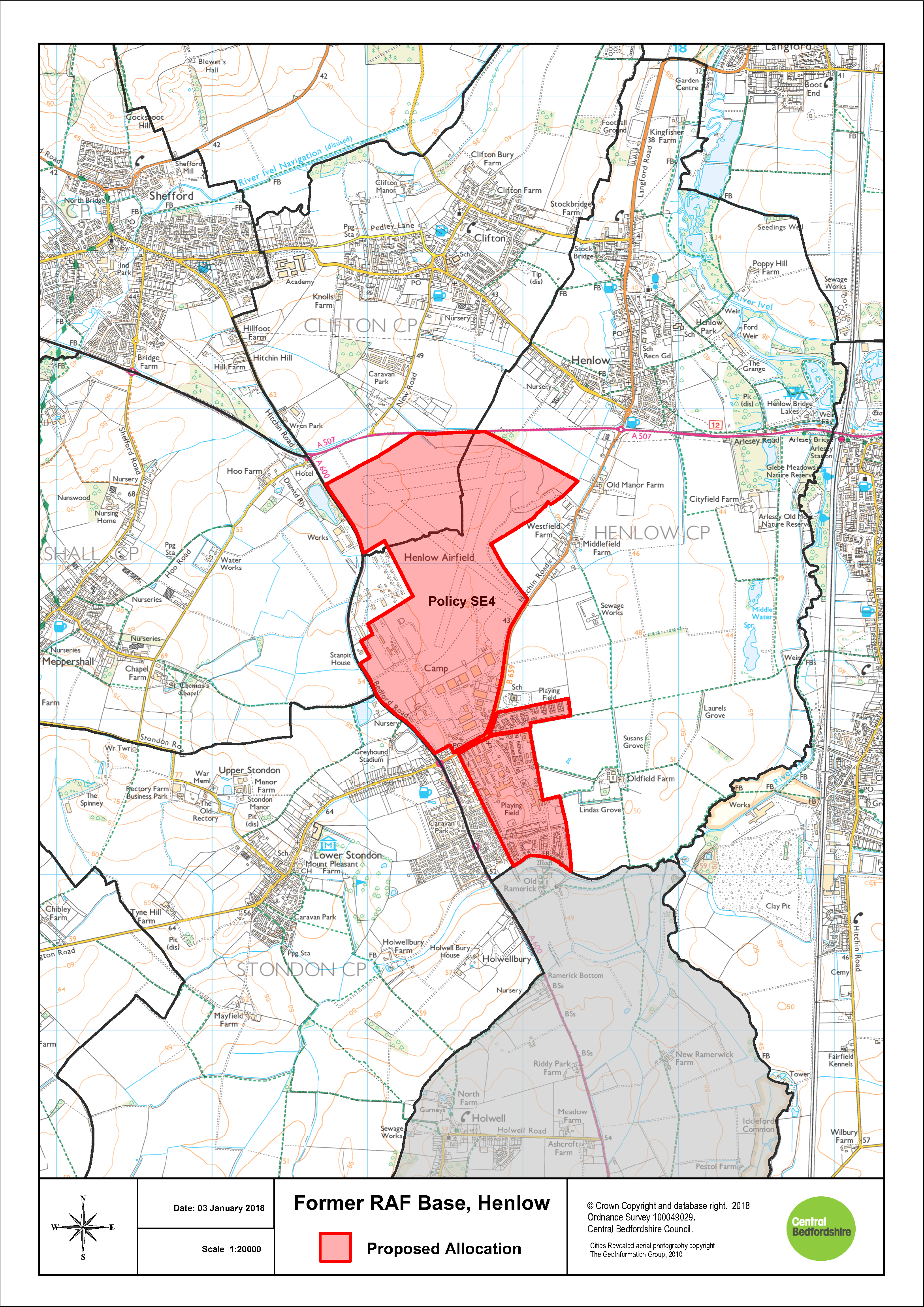
Policy SE4: Former RAF Base, Henlow
The former RAF Base at Henlow site as identified on the Proposal Map, will deliver a mixed use redevelopment that will:
- provide for up to 130 hectares of developable land comprising:
- up to 85 hectares of specialist high-technology, science, research and development uses to the north of the A659 Hitchin Road; and
- a mixed use visitor-economy and residential scheme of up to 45 hectares to the south of the A659 Hitchin Road.
- deliver necessary improvements to the road network maintaining suitable access to the site; and
- provide opportunities for sustainable transport links to be determined through a Transport Assessment
Due to the nature of neighbouring land uses, all development proposals for this site must have regard to the prevention of major accidents and limiting their consequences, including the increase of vehicular movements on the A600. Development must be designed to maintain appropriate distances between hazardous establishments and populations for the long term to reduce risk.
Development will be permitted in accordance with other relevant policies in the Development Plan and following the successful preparation of a Masterplan which provides an exemplar design response to this unique location.
The quantum of homes to be delivered within the residential element to the south of the A659 Hitchin Road and the redevelopment of existing properties (approximately 500 dwellings in total) will be determined through master planning. These dwellings would be considered as windfall and are therefore excluded from the plan housing target.
Development proposals must ensure the protection of all listed buildings, their setting and important views within the site and take full account of the Safeguarded Zone and transport restrictions associated with established neighbouring uses.
SE4: Former RAF Base, Henlow
7.8 Small and Medium Allocations
Policy HA1: Small and Medium Allocations
Sites identified on the proposals maps at Appendix 6 and listed in the table below are allocated for residential development.
In addition to the general policy requirements of this Local Plan, development of these sites must take full account of the site specific issues which are identified and set out on a site by site basis where relevant.
|
Allocation Ref |
Site Name |
Area |
Parish |
Approx Density |
Approx Capacity |
Site Area (HA) |
Additional Policy Requirements (where applicable) |
||
|
HAS01 |
Land adjoining Lewis Lane |
A1 Corridor |
Arlesey |
30 |
67 |
2.81 |
|
||
|
HAS02 |
Land rear of 214-216 High Street |
A1 Corridor |
Arlesey |
30 |
20 |
0.61 |
|
||
|
HAS03 |
Land off Meadow View |
East - West |
Aspley Guise |
30 |
37 |
1.59 |
Noise mitigation required for railway |
||
|
HAS04 |
Land at Luton Road |
South |
Barton le Clay |
40 |
168 |
7.02 |
|
||
|
HAS05 |
Land East of Barton le Clay |
South |
Barton le Clay |
30 |
498 |
27.80 |
Development Brief required (see HQ9) |
||
|
HAS06 |
Land North of Biggleswade |
A1 Corridor |
Biggleswade |
40 |
401 |
16.71 |
Will need to implement landscape buffering and GI enhancements north of the site, to protect landscape and setting of Biggleswade Common and create a softer edge to the development. Development Brief required (see HQ9) |
||
|
HAS07 |
Caddington Park |
South |
Caddington |
50 |
66 |
1.66 |
|
||
|
HAS08 |
Land on the South East of Greenway |
Central |
Campton & Chicksands |
30 |
66 |
0.47 |
Will need to provide landscaping along eastern boundary of the site, appropriate screening is needed to protect from elevated views on the site |
||
|
HAS09 |
Chapel Farm |
South |
Chalton |
30 |
54 |
3.18 |
|
||
|
HAS10 |
New Road |
Central |
Clifton |
40 |
54 |
2.25 |
Would need to safeguard existing boundary enclosure and trees with new planting and landscaping |
||
|
HAS11 |
East End Farm |
East - West |
Cranfield |
30 |
48 |
2.67 |
Site design to incorporate buffering and enhance existing woodland particularly to the eastern edge and along the existing rights of way |
||
|
HAS12 |
Land West of Lodge Road |
East - West |
Cranfield |
From Planning App. |
15 |
0.59 |
Existing Tree Preservation Orders should be protected |
||
|
HAS13 |
Land North of Greenfield Way |
A1 Corridor |
Dunton |
30 |
37 |
2.07 |
Site design to incorporate landscape buffering and green infrastructure on western boundary |
||
|
HAS14 |
Land off Eaton Park |
South |
Eaton Bray |
30 |
49 |
2.69 |
|
||
|
HAS15 |
Green Lane |
A1 Corridor |
Everton |
30 |
23 |
0.96 |
Site design to ensure that existing boundary features to be conserved |
||
|
HAS16 |
Land at Manor Farm |
A1 Corridor |
Everton |
30 |
19 |
0.81 |
|
||
|
HAS17 |
Steppingley Road |
South |
Flitwick |
40 |
216 |
9.00 |
Site design to incorporate landscape buffering to Flitwick Wood and the views towards Steppingley. Woodland planting required to strengthen the field boundary to the south-west. Mitigation required due to archaeology from Roman period |
||
|
HAS18 |
Site adjacent to Flitwick Garden Allotments, off Steppingley Road |
South |
Flitwick |
40 |
35 |
1.08 |
Explore opportunities for access through adjoining committed developments to achieve better quality design |
||
|
HAS19 |
Land at Upper Gravenhurst |
Central |
Gravenhurst |
30 |
39 |
1.62 |
|
||
|
HAS20 |
Land West of Midland Mainline Railway |
South |
Harlington |
40 |
435 |
18.14 |
Landscape buffering will be required to protect open views. Noise mitigation required for railway. Development Brief required (see HQ9) |
||
|
HAS21 |
Land West of Sundon Road |
South |
Harlington |
40 |
154 |
6.39 |
Design must be complimentary to the AONB to the south and noise mitigation will be required for the railway. Existing hedgerows to be retained |
||
|
HAS22 |
Land South of Northwood End Road |
Central |
Haynes |
30 |
29 |
1.21 |
Landscape mitigation required to the south and west and boundary hedgerows to the south to be strengthened. Must conserve the setting of Hill Farm and Greensand Ridge path |
||
|
HAS23 |
Land adjacent to Derwent Lower School |
Central |
Henlow |
30 |
101 |
5.59 |
Noise mitigation will be required for the road. Landscape buffering required to the wider rural landscape |
||
|
HAS24 |
Land to the South West of the A5 |
South |
Hockliffe |
30 |
77 |
4.25 |
Noise mitigation will be required for nearby road. Landscaping will need to consider the setting of nearby listed buildings |
||
|
HAS25 |
Land at Leighton Road |
South |
Hockliffe |
30 |
23 |
0.99 |
Landscaping will need to screen and have regard to the nearby scheduled monument to the north |
||
|
HAS26 |
A5 Watling Street |
South |
Hockliffe |
30 |
41 |
1.74 |
Landscaping will need to be sensitve to nearby listed buildings and the setting of the Scheduled Monument |
||
|
HAS27 |
Wixams Southern Extension |
East - West |
Houghton Conquest |
From Planning App. |
650 |
68.00 |
Development Brief required (see HQ9) |
||
|
HAS28 |
Bidwell Gospel Hall (Dell Mount) |
South |
Houghton Regis |
40 |
25 |
0.78 |
|
||
|
HAS29 |
Land East of Houghton Regis |
South |
Houghton Regis |
40 |
355 |
14.80 |
Development Brief required (see HQ9) |
||
|
HAS30 |
Thistle Hill Field |
A1 Corridor |
Langford |
30 |
70 |
3.94 |
|
||
|
HAS31 |
Bridge Field |
A1 Corridor |
Langford |
30 |
67 |
3.70 |
Design will need to ensure that the Right of Way to the west of site is enhanced. Noise and landscaping mitigation will be required for the railway edge |
||
|
HAS32 |
Northern Chamberlains Barn |
South |
Leighton Linslade |
40 |
175 |
16.00 |
|
||
|
HAS33 |
Land North of Soulbury Road |
South |
Leighton Linslade |
40 |
55 |
1.73 |
|
||
|
HAS34 |
The Chiltern-Hunt Land |
South |
Leighton Linslade |
40 |
138 |
5.74 |
|
||
|
HAS35 |
Wood End Lane |
East - West |
Marston Moretaine |
30 |
63 |
3.51 |
|
||
|
HAS36 |
Land North of Clophill Road |
Central |
Maulden |
30 |
45 |
0.74 |
Protection and enhancement of Maulden Wood required, including buffering |
||
|
HAS37 |
Land between 129A & 131 Clophill Road |
Central |
Maulden |
From Planning App. |
21 |
0.70 |
Protection and enhancement of Maulden Wood required, including buffering |
||
|
HAS38 |
Land fronting Silsoe Road |
Central |
Maulden |
30 |
39 |
2.37 |
|
||
|
HAS39 |
Land at 32 Shefford Road (Bandland Nursery) |
Central |
Meppershall |
30 |
55 |
3.04 |
|
||
|
HAS40 |
Land adj to Park Road /Bedford Road (A603) |
Central |
Moggerhanger |
30 |
30 |
1.45 |
|
||
|
HAS41 |
Land at Thorncote Road (Close Field) |
Central |
Northill |
30 |
21 |
0.86 |
|
||
|
HAS42 |
The Pound, Upper Caldecote |
Central |
Northill |
30 |
33 |
1.74 |
|
||
|
HAS43 |
One Acre Field, Sandy Road |
A1 Corridor |
Potton |
30 |
12 |
0.44 |
|
||
|
HAS44 |
Line Field |
Central |
Shefford |
30 |
72 |
9.20 |
|
||
|
HAS45 |
Land South and East of High Road |
Central |
Shillington |
30 |
42 |
2.33 |
Landscape buffering required on the southern boundary |
||
|
HAS46 |
Land rear of Station Road (Lower Stondon Northern Expansion) |
Central |
Stondon |
30 |
244 |
11.65 |
Landscape buffering required along the northern edge. Due to the nature of neighbouring land uses, all development proposals for this site must have regard to the prevention of major accidents and limiting their consequences, including the increase of vehicular movements on the A600. |
||
|
HAS47 |
Land off The Pastures, Lower Stondon |
Central |
Stondon |
30 |
33 |
1.37 |
Due to the nature of neighbouring land uses, all development proposals for this site must have regard to the prevention of major accidents and limiting their consequences, including the increase of vehicular movements on the A600. |
||
|
HAS48 |
Land South of High Street |
A1 Corridor |
Sutton |
30 |
37 |
2.04 |
Design will need to ensure that mature trees and hedges on site are preserved |
||
|
HAS49 |
Land East of Leighton Road |
South |
Toddington |
40 |
92 |
3.85 |
Design expected to include landscape buffering and green infrastructure to the south-western boundary |
||
|
HAS50 |
Alma Farm |
South |
Toddington |
40 |
159 |
6.61 |
Design should seek opportunities for Green Infrastructure along western boundary |
||
|
HAS51 |
Land off Flitwick Road |
South |
Westoning |
30 |
135 |
7.51 |
Noise mitigation required for the railway and appropriate landscaping required to north of the site to protect views to Flitwick |
||
|
HAS52 |
West View Farm |
South |
Westoning |
30 |
85 |
4.74 |
Noise mitigation required for the railway |
||
Please click the magnifying glasses below to view all representations made against individual parishes/small and medium site allocations.
7.9 Identified Locations for Future Growth
7.9.1 Identified land for Future Growth for the purposes of this Local Plan comprises areas which may be required to serve development needs in the longer term beyond the plan period or potentially at an earlier point in time if the wider context changes. These areas have a basic technical capacity but no housing numbers have been attributed to them and therefore they do not contribute to the Plan target of 39,350 as a 'Broad Location' would[7]. These should also not be confused with the definition applied to areas of Green Belt land as in this instance it must be demonstrated that the land is genuinely capable of development when needed.
7.9.2 Essentially there is currently insufficient technical evidence and/or supporting infrastructure to support allocation, but there is significant potential based on their location and Central Bedfordshire's position right at the centre of the Oxford-Cambridge Growth Corridor.
7.9.3 The identified land areas respond to proposals for future strategic infrastructure delivery; namely the realignment of the A1 or significant improvements through Central Bedfordshire, East West Rail, the Expressway and the expansion of Luton Airport. In each case these are either expected to enable development or in other cases they may mean that development is not feasible in a location due to the sterilisation of the land by the route of the infrastructure. All locations however based on initial technical assessment have potential for future development.
7.9.4 This land is not allocated for development at the present time, but subject to further assessment could fulfil its purpose of meeting possible longer-term development needs. Development which would prejudice later comprehensive development will be discouraged, though temporary developments which may assist in ensuring that the land is properly looked after may be acceptable. In addition valuable landscape and wildlife features and existing access for recreation should be protected and enhanced as appropriate.
7.9.5 It is expected that planning permission for the permanent development of identified land will only be granted following the partial Local Plan Review as referenced in section 5.
7.9.6 The Identified Areas for Future Development are as follows and are shown on the maps at Appendix 7:
- Land West of Luton
- North, South and East of Tempsford (east of the A1)
- Land East of Biggleswade (east of the allocated new village, south of Sutton and west of Dunton)
- Aspley Guise (North of the Railway Line)
7.10 Development of a Strategic Commitment
Houghton Regis North Strategic Allocation
7.10.1 Houghton Regis North Strategic Allocation is a major urban extension on the northern side of Houghton Regis between the A5 and the M1 junction 11a. The Houghton Regis North Strategic Allocation (SA), which sits between the M1 and the A5, will be delivered across two sites although forming a whole. Site 1 comprises the eastern side of the strategic allocation extending from the M1 to the A5120, whilst Site 2 is located to the east of the A5 to the A5120. The A5-M1 strategic link road provides the northern boundary for both sites.
7.10.2 A figure of around 7,000 new homes could be accommodated; approximately 4,600-5,600 on site 1 and approximately 1,500-1,850 on site 2. Similarly around 40 hectares of employment is planned for, 32ha of which is on site 1 and 8ha is on site 2.
7.10.3 On the 2nd June 2014 Central Bedfordshire Council Granted Outline Planning Permission for Site 1. This was comprised of: up to 5,150 dwellings (Use Class C3); up to 202,500 sqm gross of additional development in Use Classes: A1, A2, A3 (retail), A4 (public house), A5 (take away); B1, B2, B8 (offices, industrial and storage and distribution); C1 (hotel), C2 (care home), D1 and D2 (community and leisure); car showroom; data centre; petrol filling station; car parking; primary substation; energy centre; and for the laying out of the buildings; routes and open spaces within the development; and all associated works and operations including but not limited to: demolition; earthworks; engineering operations.
7.10.4 On the 18th November 2015 Central Bedfordshire Council Granted a Hybrid Planning Permission for Site 2 with details relating to the main access routes, primary road network and associated drainage and also comprises outline permission for: up to 1,850 dwellings (Use Class C3); 2FE Primary School (D1); employment land (Use Classes B1 [a-c], B2 and B8); local centre comprising retail (A1, A2, A3, A4 and A5); and community/leisure uses (D1 and D2); layout of public open spaces including sports pitches and changing rooms; natural wildlife areas and all associated works and operations including engineering operations and earthworks.
7.10.5 The above developments are supported by the recently completed new A5-M1 strategic link road and the Woodside link road. Sufficient land has been identified for removal from the Green Belt in order to accommodate the full development potential of the SA; the new Green Belt boundary is aligned with the new A5-M1 link road.
7.10.6 The delivery of the SA over two sites will allow a more detailed approach to phasing to be undertaken. The two sites will be fully integrated with each other as well as with the urban area of Houghton Regis so as to provide truly sustainable development. The timely delivery of supporting infrastructure within the strategic allocation will complement and enhance existing services and facilities as well as assisting in the regeneration of the existing urban area.
7.10.7 A Framework Plan has been prepared for the SA encompassing both Sites 1 and 2. The purpose of the Framework Plan is to provide a broad structure of the essential supporting elements of the proposed Houghton Regis North Strategic Allocation. This includes an identification of areas for residential development, employment land and associated infrastructure. The specific location of infrastructure and land uses will be developed through the production of site and area masterplans, alongside planning applications.
Policy SA5: Houghton Regis North Strategic Allocation
All masterplans and planning applications within this site allocation area, shall conform to the broad principles outlined within the Council's adopted Framework Plan for North Houghton Regis or the latest adopted amendment to that Framework Plan.
Site 1 comprises the area between the A5120 and the M1. Masterplans and planning applications will deliver a strategic allocation that:
- provides a mix of uses necessary to achieve a
sustainable community. These will include:
- approximately 5,150 homes;
- up to 30% affordable homes, subject to viability testing;
- 32 hectares of new employment land in a combination of B1, B2 and B8 Use Classes;
- commercial facilities, including local centres;
- retail units, a foodstore; and a public house;
- provision for educational facilities;
- retirement accommodation;
- community and health centre; and
- open space and green infrastructure
- provides opportunities to assist in the regeneration of Houghton Regis through the timely delivery of supporting infrastructure that complements and supports existing facilities;
- provides the opportunity for long term integration with Site 2 to facilitate the delivery of the wider strategic allocation for this area;
- provides for efficient public transport routes that link with Houghton Regis town centre and the guided busway as well as dedicated and safe pedestrian and cycle links from the new and existing neighbourhoods to local centres, employment opportunities and social and community infrastructure;
- provides a green infrastructure network that links, preserves and enhances biodiversity, landscape, heritage, access and open space features within the existing urban area, the strategic allocation and the wider countryside;
- designed to mitigate any harm caused to the significance of all designated heritage assets in the vicinity of the site. This is required in order to ensure that the public benefits of the development outweigh the any harm caused to the significance of all designated heritage assets affected by the development;
- designed to preserve all designated heritage assets within the site and shall seek to mitigate the degree of harm to the significance of all designated heritage assets and shall deliver where necessary, relevant and reasonable measures to preserve those assets and their settings for future generations, to ensure the public benefits of development would outweigh the degree of harm to the significance of designated heritage assets.
- seeks to reduce flood risk along the Houghton Brook and further downstream in Luton by engaging with the EA to explore practical opportunities that manage flood risk and minimise surface water runoff; and
- incorporates measures to adapt to climate change, minimise energy use, mitigates for loss of carbon in soils and includes renewable energy technologies.
Site 2 comprises the area from the A5 to the A5120, and extends northwards to the proposed A5-M1 Link Road. The masterplan will deliver a strategic allocation that:
- provides a mix of uses necessary to achieve a
sustainable community. These uses will include:
- approximately 1,500-1,850 homes;
- up to 30% affordable homes, subject to viability testing, to meet the needs of Central Bedfordshire and Luton residents;
- 8 hectares of new employment land in a combination of B1, B2 and B8 Use Classes within the plan period;
- commercial facilities including a local centre;
- provision for education facilities including sports and playing fields;
- retirement accommodation;
- community and health centres; and
- open space and green infrastructure.
- provides opportunities to assist in the regeneration of Houghton Regis, through the timely delivery of supporting infrastructure that complement and supports existing facilities;
- integrates with Site 1 to facilitate the delivery of the wider strategic allocation for this area;
- provides for efficient public transport routes that link with Houghton Regis town centre and the guided busway as well as dedicated and safe pedestrian and cycle links from the new and existing neighbourhoods to local centres, employment opportunities and community facilities;
- designed to mitigate any harm caused to the significance of all designated heritage assets in the vicinity of the site. This is required in order to ensure that the public benefits of the development outweigh the any harm caused to the significance of all designated heritage assets affected by the development;
- designed to preserve all designated heritage assets within the site and shall seek to mitigate the degree of harm to the significance of all designated heritage assets and shall deliver where necessary, relevant and reasonable measures to preserve those assets and their settings for future generations, to ensure the public benefits of development would outweigh the degree of harm to the significance of designated heritage assets.
- incorporates measures for the management of multimodal access both within, to and from the site including the mechanisms for their future development and funding through the development of travel plans;
- provides a green infrastructure network that links, protects and enhances the existing urban area, the strategic allocation and the wider countryside.; in addition contributions will be required to mitigate the impact of development on Houghton Regis Marl Lakes SSSI and Chalk Pit CWS and ensure its long term protection and an access strategy that includes the Houghton Regis Marl Lakes SSSI and Chalk Pit CWS. This access strategy and the GI network will be informed by a detailed ecological assessment which will determine any potential impacts as a result of increased access to the site; in addition contributions will be required to mitigate identified impacts of development on the whole site and ensure its long term protection;
- seeks to reduce flood risk along the Ouzel Brook by engaging with the Environment Agency to explore practical opportunities that manage flood risk and minimise surface water runoff; and
- incorporates measures to adapt to climate change, minimise energy use and includes renewable energy technologies.
Masterplans and planning applications will confirm the timing and phasing of the development, taking account of the capacity of both the current and proposed infrastructure.
The Green Belt boundary follows the alignment of the A5-M1 Link Road.
Any planning applications for new residential or employment
developments on any other land within the Houghton Regis
Framework Plan Area shall be considered on a case by case
basis and will be required to be accompanied by a
comprehensive master plan which demonstrates an integrated
approach to development within the wider context of the
site, and shall only be approved planning permission if
they are considered to be on balance sustainable as a
whole. Other relevant policies within the Local Plan will
apply.
SA5: Houghton Regis North Strategic Allocation
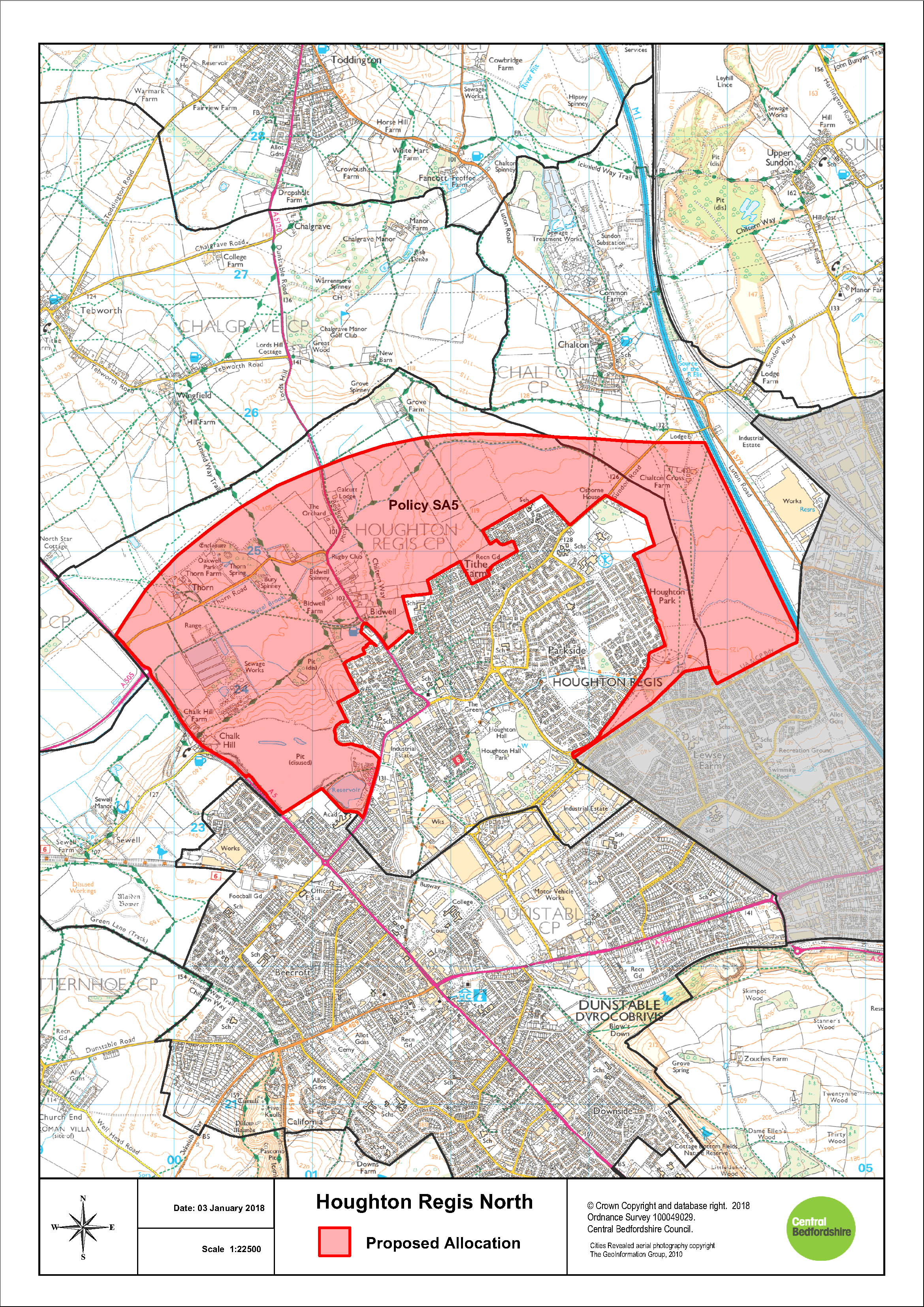
[7] Strategic
Housing Land Availability Assessment National Planning
Practice Guidance


