Sustainability Appraisal - Supplementary Report [EXAM 115/115B]
Chapter 4
Supplementary SA Findings: Stage 1
4.1 This chapter sets out the findings of the first stage of Supplementary SA work that has been undertaken, i.e. the appraisal of the revised sets of reasonable alternative strategic options including sites.
Approaches to Distributing Development Growth
4.2 As described in Chapter 2, a number of changes have been made to the suite of options for the approach to distributing development growth. The detailed SA matrix for the revised set of six options can be found in Appendix D and the findings are summarised in Table 4.1 overleaf. The six options are:
- Option 1: New settlement (village scale) – 1,500-5,000 new homes
- Option 2: New settlement (town scale) – more than 5,000 new homes
- Option 3: Village extensions – especially those with services and facilities
- Option 4: Growth around strategic roads
- Option 5: Growth around sustainable transport hubs
- Option 6: Urban extensions assumed to be 1,500-4,000
SA objective 1: To ensure that the housing needs of all residents and communities are met
4.3 It is expected that all six options would have positive effects on SA objective 1. It is likely that that the scale of individual new developments that would occur under Option 1 (smaller new settlements), Option 2 (larger new settlements), Option 4 (growth along the strategic road network), Option 5 (growth around sustainable transport hubs), and 6 (urban extensions), is most likely to support the delivery of sufficient housing to meet the identified needs of all communities within the Plan area and/or housing needs outside the Plan area. Therefore, the positive effects likely for these options are significant. Option 3 (village extensions) would provide for smaller-scale housing development so would have a minor positive effect.
Table 4.1: Summary of likely sustainability effects of options for distribution of development growth
|
SA objective |
Option 1: New settlement (village scale) – 1,500-5,000 new homes |
Option 2: New settlement (town scale) – more than 5,000 new homes |
Option 3: Village extensions – especially those with services and facilities |
Option 4: Growth around strategic roads |
Option 5: Growth around sustainable transport hubs |
Option 6: Urban extensions assumed to be 1,500-4,000 |
|
++? |
++? |
+? |
++? |
++? |
++? |
|
|
+/- |
+ |
+/-? |
? |
? |
+? |
|
++? |
++? |
+? |
+/-? |
+? |
++? |
|
+/-? |
++/-? |
-? |
+? |
++? |
++? |
|
+? |
++? |
+? |
+? |
++? |
+? |
|
-? |
+? |
--? |
-? |
++? |
+? |
|
+? |
++? |
-? |
--? |
++? |
+? |
|
+? |
+? |
-? |
--? |
+? |
+? |
|
+? |
+? |
? |
? |
? |
+? |
|
? |
? |
? |
? |
? |
? |
|
+/- |
+/- |
- |
- |
- |
+/- |
|
? |
? |
? |
? |
? |
? |
|
- |
- |
--? |
- |
- |
--? |
|
? |
? |
? |
? |
? |
? |
SA objective 2: To maintain and enhance community and settlement identities
4.4 Where options would deliver entirely new settlements (Options 1 (smaller new settlements) and 2 (larger new settlements)) it is expected that development could incorporate positive masterplanning to promote thriving and inclusive communities. Minor positive effects are therefore likely for those options in relation to SA objective 2. However, the positive effect for Option 1 is mixed with a minor negative effect as it may be more difficult to deliver a wide range of services and facilities within a smaller new development, which may make it more difficult to create an independent new settlement with a strong identity.
4.5 Option 6 (urban extensions) has the potential to integrate positively with existing communities where existing social networks may have more resilience to change. Minor positive effects are therefore also expected for that option in relation to SA objective 2 although this is uncertain and will depend on the level of existing services and facilities at the settlements to be extended.
4.6 Option 3 (village extensions) could have a minor negative effect, as extensions to smaller settlements may be less suited to accommodate new growth considering the limited level of service provision and the potential for community networks to be overburdened by relatively high levels of growth. However, this is mixed with a potential minor positive effect as new development could help to strengthen the viability of existing villages and support their services.
4.7 The effects of Options 4 (growth around strategic roads) and 5 (growth around sustainable transport hubs) are uncertain and will depend on the scale and precise location of growth.
SA objective 3: To improve accessibility to services and facilities
4.8 Option 2 (larger new settlements) and Option 6 (urban extensions) could have significant positive effects in relation to SA objective 3. The scale of growth at larger new larger settlements (Option 2) is likely to provide the critical mass to support the delivery of substantial new services and facilities and to support improvements to existing services, although it is noted that there may be a reasonably long lead in time for large new settlements. Smaller new settlements (Option 1) are likely to provide fewer new services and therefore the positive effect expected is minor. A similar contrast is noted between Options 3 and 6.
4.9 Option 3 (village extensions) would be likely to provide new residents with access to a more limited range of existing services and facilities compared to Option 6 (urban extensions). Village extensions may also be less likely to deliver new services, although all new development could have the potential to make some improvements and it is noted that existing village residents would be able to make use of any new or enhanced services provided.
4.10 Minor positive effects are also expected for Option 4 (growth around strategic roads) and Option 5 (growth around sustainable transport hubs) given that many of the larger settlements where access to services is strongest are along the strategic road network and by sustainable transport hubs. The minor positive effects expected for Option 4 are combined with minor negative effects, however, given that providing new growth around the strategic road network is less beneficial in terms of accessibility for residents who do not have a car.
SA objective 4: To support the economy and ensure that there are suitable opportunities for employment
4.11 Locating development at or adjacent to the existing larger settlements and as large-scale new settlements would help to support more sustainable employment growth. These areas can be masterplanned to provide the required infrastructure and floorspace for employment development, or may already benefit from existing employment development. Therefore, significant positive effects are expected for Option 2 (larger new settlements) and Option 6 (urban extensions) in relation to SA objective 4.
4.12 Option 1 (smaller new settlements) is likely to involve a more limited level of employment growth, and so could have a minor positive effect on SA objective 4. It is noted that Option 1 covers a scale of development from 1,500-5,000 homes, and effects may be more positive where developments are at the larger end of that scale. The positive effects expected for both Options 1 and 2 are, however, combined with potential minor negative effects as new settlements may be less likely to provide good access to the existing key employment sites in Central Bedfordshire in comparison to development that occurs as an extension to an existing larger settlement.
4.13 Option 5 (growth around sustainable transport hubs) would provide access to employment sites as well as additional employment opportunities in the neighbouring areas of Bedford, Milton Keynes and Luton via sustainable transport links and therefore significant positive effects are expected for this option.
4.14 The opportunity for growth in the warehousing sector is most directly addressed through Option 4 (growth around strategic roads) as employment development of this type generally requires easy access to the strategic road network. As such, a positive effect is expected for this option. This is likely to be minor considering the limited range of job provision and diversification of the local economy that growth of this nature is likely to support. Option 3 (village extensions) is considered to perform least favourably in relation to SA objective 4.
4.15 The more limited scale of growth at village extensions is less likely to allow for the delivery of significant new employment opportunities. These locations are also less likely to be well-related to the existing key employment sites in Central Bedfordshire, many of which are located in close proximity to the major service centres. Therefore, an overall minor negative effect is expected for Option 3.
SA objective 5: To improve the health and wellbeing of communities and reduce inequalities
4.16 It is likely that all of the options have the potential to deliver development which incorporates green infrastructure (GI) and opportunities for recreation. Therefore, all options are expected to have positive effects in relation to SA objective 5.
4.17 The larger scale of development associated with Option 2 (larger new settlements) means that there may be increased opportunities for incorporating improvements to GI and recreation provision and significant positive effects are therefore expected for that option. The smaller scale of development associated with Options 1 (smaller new settlements) and 6 (urban extensions) means that a minor positive effect is likely as while there are still likely to be good opportunities for GI provision, these may be more limited in comparison.
4.18 Option 4 (growth around strategic roads), Option 5 (growth around sustainable transport hubs) and Option 6 (urban extensions) have the potential to deliver development at or in close proximity to communities with higher levels of deprivation, at Houghton Regis and the edge of Luton. This could help support an uplift in indicators relating to deprivation, including health deprivation and disability through the provision of new community infrastructure. Furthermore, it is expected that delivering growth in close proximity to sustainable transport hubs (Option 5) could result in an increase in travel by active modes; therefore a significant positive effect is likely for that option. However, the effects are uncertain depending on location – in particular under Option 4, development may take place anywhere around the strategic road network, so not necessarily near to areas with higher deprivation.
SA objective 6: To maintain and improve the existing highway network and reduce associated indirect impacts on air quality and greenhouse gas emissions
SA objective 7: To encourage a demonstrable modal shift to more sustainable forms of transport and reduce the need to travel
SA objective 8: To maximise the potential for energy efficiency, reduce greenhouse gas emission and ensure that the built, natural environment and its communities can withstand the effects of climate change
4.19 There are many interlinkages between these three SA objectives, so they are addressed together.
4.20 It is likely that new settlements can be designed to address negative effects on the existing transport networks and contribute to resolving existing problems, for example by incorporating new infrastructure including sustainable transport links. New settlements (Options 1 and 2) and larger urban extensions (Option 6) may also provide opportunities for incorporating renewable energy infrastructure. Larger new settlements (Option 2) would provide the critical mass to incorporate more in the way of new services and facilities and infrastructure, thereby also reducing the need for residents to travel longer distances on a regular basis.
4.21 The scale of growth that would occur through Option 2 (larger new settlements) means that positive effects are likely in relation to all three of these SA objectives. The effects identified for Option 5 (growth around sustainable transport hubs) are also expected to be particularly positive for these objectives given that this option would most directly support the use of sustainable transport links.
4.22 Options 3 and 4 are expected to perform least favourably in relation to these three SA objectives. Option 3 (village extensions) is likely to result in higher levels of car use. While providing growth along the strategic road network (Option 4) could potentially result in some development at the larger settlements, this option is considered least likely to support modal shift. Significant negative effects have therefore been recorded for this option in relation to SA objectives 7 and 8. It is also noted that delivering new development around the strategic road network would place demands on its capacity and therefore a minor negative effect is expected for this option in relation to SA objective 6.
SA objective 9: To minimise the demand for water and maintain or improve water quality
SA objective 10: To reduce the risk of flooding from all sources
4.23 The likely effects of the options on these SA objectives will be largely determined by the specific location of development – for example its proximity to areas where there are known wastewater treatment capacity issues or areas at risk from surface water or groundwater flooding (such as Biggleswade, Dunstable, Flitwick, Houghton Regis and Leighton Buzzard which all have areas at risk from surface water flooding). As such, uncertain effects are expected for all options in relation to both these SA objectives. However, where development is of a larger scale there may be increased potential to incorporate exemplar design and construction including local water reuse/recycling schemes. Therefore, the uncertain effects identified for Option 1 (smaller new settlements), 2 (larger new settlements) and 6 (urban extensions) in relation to SA objective 9 are potentially minor positive.
SA objective 11: To protect and conserve soil
4.24 All of the options would result in predominantly greenfield land take so all would have negative effects on SA objective 11. However, it is likely that the smaller areas of higher value agricultural soils in Central Bedfordshire may be able to be avoided as development is delivered and therefore the negative effects identified are likely to be minor.
4.25 Option 1 (smaller new settlements), Option 2 (larger new settlements) and Option 6 (urban extensions) may provide better opportunities to achieve GI improvements and therefore minor positive effect are also expected for those three options.
SA objective 12: To protect, enhance and manage biodiversity & geodiversity
SA objective 14: To ensure the protection and enhancement of heritage assets, the historic environment and its setting
4.26 Effects relating to SA objectives 12 and 14 will be influenced by the specific location of the new development which is unknown under each option. Therefore, uncertain effects are recorded for all of the options. Central Bedfordshire does not contain any internationally designated sites; however it contains and lies in close proximity to numerous national and local biodiversity designations, as well as numerous heritage assets, which may be adversely affected as new development is delivered and occupied. The design of new development offers the potential for mitigation to be achieved; however at this stage the effects remain uncertain.
SA objective 13: To protect and enhance the landscape and townscape
4.27 Considering the predominantly rural character of much of Central Bedfordshire, and the proximity to the Chilterns AONB, new development has the potential for adverse effects on the landscape character. A number of existing settlements have been identified as having specific sensitivity to change. As such negative effects are expected for all options in relation to SA objective 13.
4.28 Under Option 3 (village extensions) the negative effects could be significant given that effects may be more pronounced and harder to mitigate where development occurs at smaller villages.
4.29 Option 6 (urban extensions) may result in negative effects on the established townscape of larger settlements and could be most likely to result in development occurring by Luton, Houghton Regis and Dunstable for example which all lie partially within the setting of the Chilterns AONB. This option could therefore also have a significant negative effect although in all cases the effects are uncertain until the specific location and design of developments are known.
4.30 Many of the effects identified in relation to the six options are uncertain because they will depend on the specific location of development. For example, a large new settlement located in an area of high flood risk close to the AONB would have very different effects to one located in a less sensitive location. However, overall Options 2 (larger new settlements) and 5 (growth around sustainable transport hubs) are expected to have the highest number of significant positive effects against the SA objectives.
4.31 The larger scale of development that would result from Option 2 means that there should be particularly good opportunities for the provision of services and facilities, employment opportunities, green infrastructure and sustainable transport infrastructure as part of the new development. Where specific thresholds for the provision of facilities such as schools exist, they are most likely to be met under this option. However, it is noted that lead in times may be long for a larger new settlement meaning that some of the positive effects would be seen over the medium-long term.
4.32 New developments should be more self-contained and more easily able to establish their own character. Option 1 (smaller new settlements) does not perform as well as Option 2 because smaller new settlements would not provide as good opportunities for creating a relatively self-contained settlement with a wide range of services, facilities and employment opportunities.
4.33 Option 5 (growth around sustainable transport hubs) performs particularly well in relation to the air quality, climate change and sustainable transport SA objectives because of the ability to reduce levels of car use, and the accessibility to services, facilities and jobs for people without access to a car also contributes to the good performance of that option. In comparison,
4.34 Option 4 (growth around strategic roads) performs relatively poorly in the SA as it would be likely to facilitate high levels of car use amongst residents, with the associated impacts on air quality and greenhouse gas emissions.
4.35 Smaller developments that would occur under Option 3 (village extensions) would be likely to have much less in the way of on-site service provision compared to other options and levels of car use may be higher as residents need to travel to access jobs, services and facilities elsewhere. That option performs least well against the SA objectives.
4.36 Option 6 (urban extensions) performs better than Option 3 (village extensions) in the SA as development on the edge of larger urban areas would provide residents with easier access, particularly via sustainable modes of transport, to services, facilities and employment opportunities.
4.37 Overall, the best performing options are Option 2 (larger new settlements), Option 5 (growth around sustainable transport hubs), and Option 6 (urban extensions), and the poorest performing are Option 3 (village extensions) and Option 4 (growth around strategic roads). Option 1 (smaller new settlements) falls in the middle of these two groups of options in terms of the likely sustainability effects.
4.38 As described in Chapter 2, two alternative options for the employment strategy have been identified and appraised:
- Option 1: Provide land to meet some of the footloose regional demand for strategic warehousing, in addition to the land allocated to meet local employment need.
- Option 2: Do not provide land to meet some of the footloose regional demand for strategic warehousing.
4.39 The detailed SA matrix for these two options can be found in Appendix E and the findings are summarised below.
4.40 The effects of Option 2 are expected to be negligible (0) in relation to all but one of the SA objectives, as the option would not involve any development taking place (the appraisal focuses just on the effects of not providing land for footloose strategic warehousing - it is not an appraisal of the employment land being provided in the Local Plan to meet local needs).
4.41 The effects of Option 1 on the SA objectives are more varied. Potential negative effects have been identified in relation to several of the environmental SA objectives including SA objectives 12: biodiversity and geodiversity, 13: landscape and 14: historic environment, due to the presence of sensitive features and other constraints such as designated sites, listed buildings, scheduled monuments and the Chilterns AONB within the A1 and M1 corridors where strategic warehousing sites are expected to be located. The negative effects on the landscape and historic environment could be considered to be potentially significant because of the value of sensitive features and their proximity to those areas, and because strategic warehousing can be of a large scale and in some instances may feature prominently in the landscape, as well as requiring supporting infrastructure. However, in all cases these effects are uncertain until the specific location and design of sites is known and it is recognised that it may be possible to mitigate effects, for example through appropriate design.
4.42 Option 1 could also have minor negative effects on SA objectives 9: water resources and quality, 10: flood risk and 11: soils, as there are waterbodies, Source Protection Zones, areas of high flood risk and high quality agricultural land within the A1 and M1 corridors, all of which could be adversely affected by the development of strategic warehousing sites. Again, the potential minor negative effects are uncertain until the specific location of sites is known. Effects on flood risk may also be able to be mitigated through appropriate design, for example the incorporation of SuDS and the implementation of appropriate construction and operational practices onsite.
4.43 The effects of Option 1 on SA objective 6: highways and air quality could be significantly negative, as there are known to be areas within the A1 and M1 corridors already affected by congestion and poor air quality, which could be compounded by HGV movements. While it may be possible to incorporate mitigation such as the provision of new bus services, most employees are likely to travel to these types of sites via car; therefore potential minor negative effects are also identified in relation to SA objectives 7: sustainable transport and 5: health and equality. However, the effects on SA objective 5 are mixed overall as a potential minor positive effect is also identified due to the fact that providing additional employment opportunities at strategic warehousing sites would benefit the local economy and so should help to address economic inequalities within Central Bedfordshire.
4.44 The effects of Option 1 on SA objectives 3: services and facilities and 4: employment could also be positive as the provision of new strategic warehousing sites would increase employment opportunities locally (as well as for people living outside of Central Bedfordshire) and, depending on where sites are located, people may have good access to services and facilities at nearby towns.
4.45 Option 2 would have a minor negative effect on SA objective 4: employment because there is widely acknowledged regional demand for footloose logistics warehousing sites associated with the strategic transport network. Given Central Bedfordshire's location on the strategic transport network, it is well-placed to contribute towards meeting a proportion of this demand. If the Council were not to make any provision for such footloose warehousing through the Local Plan, this would have a minor negative effect on support for the regional and local economy and would also reduce the number and range of job opportunities that would otherwise be made available. It is considered to be a minor rather than significant negative effect as this type of development could potentially be provided elsewhere along the strategic transport network in this part of the country, thereby meeting demand.
4.46 As noted previously, Option 2 would have negligible effects on all but one of the SA objectives, with exception being a minor negative effect against SA objective 4: employment due to the lost opportunity to contribute towards regional and local economic development and associated jobs.
4.47 The effects of Option 1 are generally positive in relation to the social and economic SA objectives, as warehousing sites would provide employment opportunities and potentially help to address inequalities.
4.48 However, the effects of Option 1 on the environmental SA objectives are generally negative. Because strategic warehousing developments are usually large in scale, they can be prominent features in the landscape and any adverse effects on the landscape and cultural heritage, in particular, may be difficult to mitigate.
4.49 The nature of these developments also means that they are likely to be located close to the main roads, with many employees likely to travel to work via car with the associated impacts on air quality and greenhouse gas emissions. However, the negative effects are uncertain until the location and design of sites are known, and mitigation proposals are detailed. As the effects at this strategic level of assessment are so uncertain, it is difficult to conclude whether the social and economic benefits of warehouse sites could outweigh the potential negative effects.
4.50 The audit trail of residential site options in Appendix C (see Table C.5) lists the 19 reasonable alternative options that have been identified and subject to SA. These sites are mapped in Figure 4.1 at the end of this chapter. As described in Chapter 2, not all of these options had previously been subject to SA – many of the site options have been identified by CBC following a review of whether alternative boundaries or capacities should be considered for certain sites (where this is the case, these comprise reasonable alternative options which should be appraised individually).
4.51 Table 4.2 overleaf presents a summary of the SA findings for the 19 residential site options. The likely sustainability effects of these sites are summarised below the table. The detailed SA matrices for each site option can be found in Appendix F.
Table 4.2: Summary of SA findings for the residential site options
|
1. Housing |
2. Communities |
3. Services & Facilities |
4. Employment |
5. Health & Equality |
6. highways & Air Quality |
7. Sustainable Transport |
8. Energy & Climate Change |
9. Water Resources & Quality |
10. Flood Risk |
11. Soil |
12. Biodiversity & Geodiversity |
13. Landscape |
14. Historic Environment |
|||||
|
Green Belt |
Settlement identities |
Employment support |
Town centres |
Regeneration |
GI |
ALC |
PDL |
|||||||||||
|
Arlesey Option 1 (up to 2,000 homes) |
++ |
0 |
- |
++ |
0 |
+ |
0 |
++ |
0? |
+ |
+? |
0? |
0 |
--? |
0 |
++/-? |
+/- |
-? |
|
Arlesey Option 2 (up to 2,000 homes) |
++ |
0 |
- |
++ |
0 |
+ |
0 |
++ |
0? |
+ |
+? |
0? |
0 |
--? |
0 |
+/-? |
+/- |
-? |
|
Arlesey Option 3 (up to 1,800 homes) |
++ |
0 |
- |
++ |
0 |
+ |
0 |
++ |
0? |
+ |
+? |
0? |
0 |
--? |
0 |
+/-? |
+/- |
-? |
|
Aspley Guise (up to 3,000 homes) |
++ |
0 |
-? |
++ |
0 |
+ |
0 |
++ |
0? |
++ |
+? |
0? |
0 |
--? |
0 |
-? |
+? |
-? |
|
Biggleswade East Phase 1 (up to 1,500 homes) |
++ |
0? |
+ |
++ |
0 |
+ |
0 |
++ |
0? |
+ |
+? |
0? |
-? |
--? |
0 |
-? |
+? |
0? |
|
Biggleswade East Phase 2 (up to 5,500 homes) |
++ |
0? |
- |
++ |
+? |
+ |
0 |
++ |
0? |
+ |
+? |
0? |
-? |
--? |
0 |
-? |
+? |
--? |
|
Henlow Airfield and Camp (1,000 homes) |
++ |
0 |
+ |
++? |
+ |
+ |
0 |
++ |
--? |
+ |
+? |
0? |
0 |
--? |
+ |
+/-? |
+? |
--? |
|
Houghton Regis North (between 4,150 and 5,150 homes) |
++ |
-- |
-? |
++ |
+ |
+ |
++? |
++ |
--? |
+ |
+? |
0? |
0 |
--? |
0 |
+/-? |
+? |
-? |
|
Luton North Option 1 (up to 4,000 homes) |
++ |
-- |
- |
++ |
++ |
+ |
+ |
++ |
-? |
+ |
+? |
0? |
0 |
--? |
0 |
+/-? |
--? |
-? |
|
Luton North Option 2 (up to 3,100 homes) |
++ |
-- |
- |
++ |
+ |
+ |
+ |
++ |
-? |
+ |
+? |
0? |
0 |
--? |
0 |
+/-? |
-? |
-? |
|
Luton North Option 3 (up to 3,600 homes) |
++ |
-- |
- |
++ |
+ |
+ |
+ |
++ |
-? |
+ |
+? |
0? |
0 |
--? |
0 |
+/-? |
-? |
-? |
|
Luton West Option 1 (up to 2,000 homes) |
++ |
-- |
- |
++? |
+ |
+? |
+? |
++ |
--? |
+ |
+? |
0? |
0 |
--? |
0 |
+/-? |
-? |
0? |
|
Luton West Option 2 (up to 3,500 homes) |
++ |
-- |
- |
++? |
+ |
+? |
+? |
++ |
--? |
+ |
+? |
0? |
0 |
--? |
0 |
+/-? |
--? |
0? |
|
Luton West Option 3 (upwards of 4,600 homes) |
++ |
-- |
- |
++? |
+ |
+? |
+? |
++ |
--? |
+ |
+? |
0? |
0 |
--? |
0 |
+/--? |
--? |
-? |
|
Marston Moretaine North (Marston Thrift) (up to 1,500 homes) |
++ |
0 |
--? |
++? |
0 |
+? |
0 |
++ |
-? |
+ |
+? |
0? |
0 |
--? |
0 |
+/-? |
+? |
-? |
|
Marston Moretaine South (Marston Vale) (up to 5,000 homes) |
++ |
0 |
--? |
++ |
++ |
+ |
0 |
++ |
-? |
++ |
+? |
0? |
0 |
--? |
+ |
+/-? |
+? |
-? |
|
North and North East Sandy (4,750 homes) |
++ |
0 |
-? |
++? |
+? |
+ |
+? |
++ |
--? |
+ |
+? |
0? |
0 |
--? |
0 |
+/-? |
-? |
-? |
|
Tempsford South and Tempsford Airfield (up to 10,000 homes) |
++ |
0 |
-- |
++ |
+ |
+ |
+? |
++ |
-? |
+? |
+? |
0? |
0 |
--? |
+ |
+/-? |
-? |
--? |
|
Wixams South (up to 650 homes) |
++ |
0 |
- |
++ |
0 |
+ |
0 |
++ |
0? |
+ |
+? |
0? |
0 |
--? |
0? |
+/-? |
+? |
-? |
SA objective 1: To ensure that the housing needs of all residents and communities are met
4.52 All 19 sites are being considered primarily for residential use. It is expected that all sites would benefit a range of residents given that Local Plan policy on Housing Mix requires new development to provide an appropriate mix of housing types, tenures and sizes. Site options in close proximity to Luton (i.e. Luton North Options 1-3 and Luton West Options 1-3) would help contribute to the unmet housing need of Luton Borough within that Housing Market Area (HMA). All 19 sites are expected to have significant positive effects in relation to SA objective 1.
4.53 It should be noted that the options which would provide lower levels of housing (i.e. Arlesey Option 3, Luton North Option 2 and Luton West Option 1) are also expected to support the lowest levels of affordable housing provision.
SA objective 2: To maintain and enhance community and settlement identities
4.54 As shown in Table 3.1 in the previous chapter, there are two elements to the appraisal of options against this SA objective – the first relating to the site's position in relation to the Green Belt and the second relating to the effects on community and settlement identities.
4.55 The six sites in closest proximity to Luton (Luton North Options 1-3 and Luton West Options 1-3) all contain land that is within the Green Belt. Significant negative effects are therefore expected for these sites in relation to the first element of this SA objective[17]. Significant negative effects are also expected for Houghton Regis North which contains Green Belt land. The remaining 12 sites are outside of the Green Belt and therefore neutral effects are expected for the first part of this SA objective.
4.56 Three sites are expected to have a significant negative effect in relation to the second element of this SA objective. Development at Marston Moretaine North (Marston Thrift) or at Marston Moretaine South (Marston Vale) could contribute to coalescence between a number of smaller settlements (including Marston Moretaine, Lower Shelton and Cranfield) as well impacts on the identities of these settlements. Similarly, development at Tempsford South and Tempsford Airfield could contribute to coalescence with the settlements of Everton and Sandy with Tempsford.
4.57 Fourteen of the residential sites are expected to have minor negative effects in relation to the character of nearby settlements. For 11 of these sites[18] the minor negative effects are more certain considering that there could be a contribution to settlement coalescence. For three sites (Aspley Guise; Houghton Regis North; and North and North East Sandy) the minor negative effects are uncertain. The negative effects identified for Aspley Guise and North and North East Sandy relate to the potential difficulty to integrate new development as a result of the presence of a railway line or strategic road which might create severance between the new development and existing settlements. Uncertainty is identified given that this issue may be able to be resolved when specific proposals come forward. At Houghton Regis North, the potential negative effect is associated with the potential for coalescence to occur with Luton to the east and Chalton to the north; however there is uncertainty because of the presence of the A5 which means that there is a defensible barrier between Houghton Regis and Chalton.
4.58 Only two sites (Biggleswade East Phase 1 and Henlow Airfield and Camp) are expected to have a positive effect in relation to the second part of SA objective 2.
4.59 It is considered likely that development directly to the east of Biggleswade (Phase 1) could integrate well with the existing settlement and contribute to the identity of the existing community. For Biggleswade East Phase 2, a minor negative effect has been recorded in relation to this part of SA objective. That site would represent a strategic increase in housing development within the existing countryside further to the east of the town meaning there could be detrimental impacts on settlement character. The Phase 2 site option could also negatively affect the rural and separated nature of the villages of Sutton and Dunton.
4.60 Development at Henlow Airfield and Camp would take in land which is currently developed and would not result in a major extension of the current settlement boundary. As such, benefits may occur in terms of settlement identity and a minor positive effect is expected in relation to the second part of SA objective 2.
SA objective 3: To improve accessibility to services and facilities
4.61 All of the residential site options are likely to support the delivery of new services and facilities in Central Bedfordshire. This will help meet the needs of new residents as homes are occupied and could also benefit existing residents. All of the site options are located in close proximity to existing services and facilities at settlements within Central Bedfordshire or within neighbouring Districts, including at Luton (sites Luton North Options 1-3 and Luton West Options 1-3) and Milton Keynes (Aspley Guise). Significant positive effects are therefore expected for all 19 site options effects in relation to SA objective 3.
4.62 Where potential issues relating access to the suitability or accessibility of existing local services and facilities or provision of a required new services and facilities to support growth have been identified, the potential positive effect is uncertain. This is the case for six site options. At Henlow Airfield and Camp the nearby service provision is relatively limited and the development of the site may result in the loss of the existing onsite services. Development at Marston Moretaine North (Marston Thrift) is not of a scale to provide a new secondary school and nearby facilities have been identified as having existing capacity pressures. For Luton West Options 1-3 the accessibility of existing services and facilities within Luton from the site will be dependent in part upon the delivery of new infrastructure to support access across the M1. At North and North East Sandy, the uncertainty is associated with the potential for development of the site to result in competition with the town centre of Sandy.
SA objective 4: To support the economy and ensure that there are suitable opportunities for employment
4.63 As described in Table 3.1 in the previous chapter, there are two elements to the appraisal of options against this SA objective – the first relating to the provision of employment opportunities and the second to the vitality/viability of town centres.
4.64 All of the site options are being considered primarily to accommodate new housing and for the sites where employment land is not proposed alongside the housing, the potential for making a contribution to the local economy beyond the construction phase is likely to be limited to non-B uses such as employment in retail units and schools and, indirectly, to the provision of homes for working age people.
4.65 However, new employment land is to be provided as part of the development of 12 of the site options[19]. For two of the site options (Luton North Option 1) and Marston Moretaine South (Marston Vale) this would be more than 10ha; therefore significant positive effects are likely in relation to the first part of this SA objective for those site options. A further 10 site options[20] are likely to have a minor positive effect as they will provide employment land, but less than 10ha. For Biggleswade East Phase 2 and North and North East Sandy, the quantum of the employment land to be provided is unknown. Therefore, the positive effects identified for these sites are uncertain. Uncertain minor positive effects are also identified for the North and North East Sandy site given that the site promoter has indicated that an unknown amount of employment land could be provided at the site.
4.66 For the seven remaining sites[21] no employment land is expected to be provided as part of the development. Therefore, neutral effects are expected in relation to the first part of SA objective 4.
4.67 The second element of this SA objective relates to the potential for the site options to support the viability of town centres. As described in relation to SA objective 3, all of the site options being considered are relatively well-related to existing settlements within Central Bedfordshire and, in some cases, in neighbouring districts. All 19 sites are therefore expected to have minor positive effects in relation to the second element of SA objective 4. However, the potential positive effects are uncertain for Luton West Options 1-3 and Marston Moretaine North (Marston Thrift) as access on foot from these sites to the nearby centres may be limited due to the presence of the strategic road network.
SA objective 5: To improve the health and wellbeing of communities and reduce inequalities
4.68 As described in Table 3.1 in the previous chapter, there are two elements to the appraisal of options against this SA objective – the first relating to regeneration/deprivation and equality, and the second to green infrastructure for health and wellbeing.
4.69 Ten of the 19 site options[22] are not located within or in close proximity to areas of higher deprivation. These sites are therefore expected to have neutral effects in relation to the first element of SA objective 5. Only one site (Houghton Regis North) takes in land which is within an area of higher deprivation. This site is expected to have significant positive effects in relation to the first element of SA objective 5, given that new development may directly help to deliver regeneration in that area. Minor positive effects are expected for the remaining eight site options[23] which are in close proximity to, but not within, areas of higher deprivation.
4.70 All sites would fall within or are in close proximity to areas of the strategic green infrastructure network and therefore could help to support the incorporation of multi-functional green infrastructure as new development occurs. Significant positive effects are therefore expected for all 19 site options in relation to the second part of SA objective 5.
4.71 It should be noted that compared to Arlesey Option 1, Arlesey Options 2 and 3 have less certainty in relation to the delivery of the new country park as the land for its provision would fall outside of the site boundary under those two options. A new country park, if delivered, would benefit new and existing residents in the surrounding area in terms of access to open space. The provision of a country park would also strengthen the significant positive effect expected for the Arlesey Option 1 site in relation to the second part of SA objective 5 in the long term.
SA objective 6. To maintain and improve the existing highway network and reduce associated indirect impacts on air quality and greenhouse gas emissions
4.72 All new residential development in Central Bedfordshire is likely to result in increased traffic generation. Access to the strategic road network and sustainable transport links is provided from most of the site options and many options would be supported by new highways improvements. Mitigation relating to traffic generation is provided through draft Local Plan policies relating to Strategic Transport Improvements, Mitigation of Transport Impacts on the Network, Connectivity and Accessibility, Development and Public Transport Interchanges and Low Emission Vehicles.
4.73 Of the 19 site options, six (Luton North Options 1-3; Marston Moretaine North (Marston Thrift); Marston Moretaine South (Marston Vale)); and Tempsford South and Tempsford Airfield are expected to have minor negative effects in relation to SA objective 6 due to the potential for increased road stress and congestion resulting from development which would require the provision of new infrastructure and/or lead to indirect contributions to increases in existing air pollution within AQMAs. These effects are uncertain, however, dependent upon the potential for mitigation to be achieved and recognising the good level of access to the strategic road network and/or sustainable transport links from these sites.
4.74 Six sites are expected to have significant negative effects in relation to this SA objective. This includes two sites (Houghton Regis North and North and North East Sandy) which are in particularly close proximity to AQMAs where the existing air quality issues could be exacerbated. It also includes three site options by Luton (Luton West Options 1-3). It is likely that the three Luton West Options could lead to the aggravation of air pollution within the three AQMAs in Luton as well as one in Dunstable. These three options would also require access to Junction 10 of the M1 which is likely to adversely affect traffic flows on the local and strategic road network. A significant negative effect has also been identified for Henlow Airfield and Camp considering the constraints on the number of vehicle movements on the A600 which would be one of main points of access to this site.
SA objective 7: To encourage a demonstrable modal shift to more sustainable forms of transport and reduce the need to travel
4.75 All of the site options are expected to have positive effects in relation to SA objective 7. The positive effects for Marston Moretaine South (Marston Vale) and Aspley Guise are likely to be significant given that these sites are within walking distance of railway stations as well as bus stops which benefit from frequent services. Marston Moretaine South (Marston Vale) is in close proximity to two railway stations at Lidlington and Millbrook respectively, while the site at Aspley Guise is in close proximity to Aspley Guise railway station.
4.76 Minor positive effects are expected for the remaining 17 site options as they would provide access to some sustainable transport links but are not in close proximity to both railway links and frequent bus services. It is noted that while parts of the site at North and North East Sandy lie in close proximity to the railway station at Sandy, the large size of the site means that some parts would be quite a distance from the station. Furthermore, the railway line acts to separate the north east of the site from the railway station and other services and facilities within Sandy.
SA objective 8: To maximise the potential for energy efficiency, reduce greenhouse gas emission and ensure that the built, natural environment and its communities can withstand the effects of climate change
4.77 As described above in relation to SA objective 7, all 19 residential site options would provide a good level of access to sustainable transport links, so increases in transport-related greenhouse gas emissions resulting from development could be minimised. Mitigation provided through local planning policy (draft Local Plan policy Connectivity and Accessibility) is expected to further promote the aim of minimising greenhouse gas emissions. Minor positive effects are therefore expected for all sites in relation to SA objective 8.
SA objective 9: To minimise the demand for water and maintain or improve water quality
4.78 Land within the boundaries of all of the residential site options falls within either the Upper Lea catchment (Luton North Options 1-3 and Luton West Options 1-3) or the Upper Bedford and Ouse catchment (all remaining sites). Climate change is likely to contribute to water supply stress in the coming years in Central Bedfordshire.
4.79 Information from the Water Cycle Study Stage 2[24] indicates that Bedford, Biggleswade, Clifton, Marston Moretaine, Shillington and Tempsford are all forecast to exceed their permitted dry weather flow as a result of planned growth during the Local Plan period. These settlements all lie within the Upper Bedford and Ouse catchment area. Continued liaison between Central Bedfordshire Council and the Water Companies, as well as between developers and Water Companies, is essential to ensure that additional wastewater treatment works (WwTW) capacity is also in place in time to accommodate the planned growth, and that there will be no detriment to service to customers or to the environment. It is expected that this liaison on the investment required to limit the potential for adverse impacts on WwTW capacity will address this issue. Therefore, likely but currently uncertain neutral effects are identified for all residential site options in relation to SA objective 9.
SA objective 10: To reduce the risk of flooding from all sources
4.80 The majority (17) of the residential site options are on land which is mostly not at risk of flooding from overflowing rivers. These 17 site options are therefore expected to have neutral effects in relation to SA objective 10. Only Biggleswade East Phases 1 and 2 contain more substantial areas of land which fall within Flood Zone 2 and Flood Zone 3. Minor negative effects are therefore expected for these two site options in relation to SA objective 10.
SA objective 11: To protect and conserve soil
4.81 As described in Table 3.1 in the previous chapter, there are two elements to the appraisal of options against this SA objective – the first relating to greenfield and agricultural land quality and the second to previously developed land.
4.82 All 19 residential site options contain large areas of greenfield land including sizeable areas of Grade 1, Grade 2 or Grade 3 agricultural soils. Therefore, potential significant negative effects are identified in relation to the first part of this SA objective. An element of uncertainty is attached until specific proposals for the sites come forward, and because the available data does not distinguish between Grade 3a and Grade 3b land (only Grade 3a land and above is considered to be the best and most versatile agricultural land).
4.83 Henlow Airfield and Camp; Marston Moretaine South (Marston Vale); and Tempsford South and Tempsford Airfield are the only sites that are expected to have a minor positive effect in relation to the second element of SA objective 11. While these sites contain mostly greenfield land, all have a history of uses which could result in land contamination. Development at these locations could therefore help promote the remediation of contaminated land in Central Bedfordshire. Development at the Henlow Airfield and Camp site would also likely result in the reuse of some previously developed land.
SA objective 12: To protect, enhance and manage biodiversity & geodiversity
4.84 One significant positive effect is identified on SA objective 12, in relation to Arlesey (Option 1). This option provides for the delivery of a new country park within the site boundaries which would help to mitigate the potential for increased recreational pressure on biodiversity sites nearby and would improve habitat connectivity in the area. Arlesey Options 2 and 3 provide less certainty for the delivery of the country park than Arlesey Option 1, as these two options would not incorporate the new country park within their boundaries. Minor positive effects are therefore associated with those two options. In all three cases, likely effects are mixed as the development proposed could also have minor negative effects on biodiversity assets in the area.
4.85 Only one of the residential site options (Luton West Option 3) could have a significant negative effect on biodiversity. This site is located in relatively close proximity to Blow's Down SSSI at which increases in recreational use and noise and light pollution may cause harm. Furthermore, the site contains two County Wildlife Sites (CWSs). The other site options considered for Luton West (Options 1 and 2) are expected to have minor negative effects in relation to this SA objective. These sites lie further away from the SSSI and contain fewer CWSs. Luton West Option 1 does not contain any CWSs but is adjacent to three, while Luton West Option 2 contains Badgerdell Wood CWS. For all three of these options, substantial new open space is to be incorporated. This is likely to go some way to help mitigate recreational pressures on nearby biodiversity sites and could also help to promote habitat connectivity in the area. Therefore, the negative effects are recorded in combination with minor positive effects.
4.86 Henlow Airfield and Camp; Luton North Options 1-3; Marston Moretaine North (Marston Thrift); Marston Moretaine South (Marston Vale); Tempsford South and Tempsford Airfield; Wixams South; Houghton Regis North; and North and North East Sandy are also expected to have mixed effects in relation to this SA objective.
4.87 The Luton North Options all lie in close proximity to designated biodiversity sites but the potential for improvements to the local biodiversity network including the provision of ecological corridors or stepping stones has also been identified. Similarly, Tempsford South and Tempsford Airfield is near to a number of nationally designated sites; however the site is expected to deliver a significant amount of accessible open space which may reduce pressure on nearby biodiversity sites.
4.88 At Marston Moretaine North the close proximity of biodiversity designations means that there is potential for habitat disturbance, but there is also potential for improved connectivity between the nearby SSSI, Local Nature Reserve (LNR) and CWSs. This is also the case at Marston Moretaine South and Wixams South where the nearby CWSs lie within or in close proximity to the biodiversity network and in close proximity to the Greensand Ridge Nature Improvement Area, meaning there is potential for improvements to ecological connectivity on a strategic scale.
4.89 The Henlow Airfield and Camp site currently lies in an area with limited connection to the biodiversity network meaning that new ecological corridors could be of particular benefit to wildlife in this area. The site is in close proximity to local biodiversity designations meaning that habitat disturbance might result as development occurs and is occupied and therefore an overall mixed effect is recorded for this site option in relation to SA objective 12. The Houghton Regis North and North and North East Sandy sites are both to provide substantial amounts of new open space to help limit the potential for increased recreational pressures on nearby biodiversity sites, which could also support habitat connectivity in the area.
4.90 The three remaining site options (Aspley Guise, Biggleswade East Phase 1 and Biggleswade East Phase 2) are expected to have minor negative effects alone in relation to this SA objective. These sites contain or are in close proximity to areas of Priority Habitat or CWSs which may mean that habitat fragmentation or disturbance results as development is delivered and occupied.
4.91 Local planning policy would help to provide mitigation as far as is possible in relation to impacts on wildlife in the plan area. This is of particular relevance where development could have adverse effects relating to habitat loss and fragmentation. Draft policies on Nature Conservation and Enhancing Ecological Networks, for example, require that new developments contribute positively to local biodiversity and ensure that designated sites are protected.
SA objective 13: To protect and enhance the landscape and townscape
4.92 The Chilterns AONB lies within Central Bedfordshire near the boundary with Luton, in close proximity to Dunstable and Houghton Regis. Significant negative effects are expected where development might result in harm to the setting and special character of this designated landscape. This includes a number of the site options in close proximity to the boundary with Luton Borough (Luton North Option 1 and Luton West Options 2 and 3). The boundaries for the other Luton site options (Luton North Option 2-3 and Luton West Option 1) have been drawn to be considerate of the topography and landscape sensitivities of the area, so as to limit the potential for adverse impacts on the AONB. Therefore, for those site options, the negative effects recorded are minor.
4.93 Only two further site options (Tempsford South and Tempsford Airfield and North and North East Sandy) are expected to have minor negative effects alone in relation to SA objective 13. Development at these sites has the potential to impact upon the sensitivities of the landscape character area in which they lie.
4.94 The three site options at Arlesey are expected to have mixed (minor positive and minor negative) effects on landscape character. This land has been identified in the site assessment work as having low/medium landscape sensitivity and there is potential for development to be integrated well within the local landscape. Development at this location could, however, result in detrimental impacts on the existing open nature of surrounding arable farmland.
SA objective 14. To ensure the protection and enhancement of heritage assets, the historic environment and its setting
4.95 Only three sites (Biggleswade East Phase 2; Henlow Airfield and Camp; and Tempsford South and Tempsford Airfield) contain designated heritage assets. Development at these site options is considered to have potential for particular harm on these heritage assets or their respective settings. Therefore, a significant negative effect on this objective is expected.
4.96 Thirteen of the 19 site options[25] are expected to have minor negative effects in relation to SA objective 14. These sites do not contain designated heritage assets but all lie in close proximity to such features meaning there is potential for impacts upon their settings.
4.97 Neutral effects are expected for the remaining three site options[26]. These sites are located a substantial distance away from the closest heritage assets and/or there is existing development present between the site and the identified assets meaning the potential for effects on their setting is minimal.
4.98 The effects for all of the site options are uncertain, however, until specific proposals are set out for each site. It is noted that the sites all contain at least one Archaeological Notification Area and development could allow for the investigation and recording of heritage assets of archaeological significance. These processes could promote a better understanding of local assets dependent upon how they are eventually undertaken.
4.99 The likely sustainability effects of the 19 residential site options are not particularly varied in terms of the number of likely significant positive and negative effects identified. The most significant positive effects associated with a single residential site option is five, which is the case for Marston Moretaine South (Marston Vale). There are only two potential significant negative effects associated with that site, so overall it performs best against the SA objectives. Looking across the SA objectives, the other sites that perform relatively well are Arlesey (in particular Option 1), Aspley Guise, Biggleswade East Phase 1, and Wixams South.
4.100 The three Luton West options perform the least well, with three significant negative effects associated with Option 1, four with Option 2 and five with Option 3. The Luton North options perform slightly better, but not as well as many of the other options. Luton North Option 1 also has three significant negative effects but these are counterbalanced by four significant positive effects. The other two Luton North options have two significant negative and three significant positive effects each. Tempsford South and Tempsford Airfield performs similarly to the Luton options, with three significant negative effects.
4.101 Henlow Airfield and Camp and Houghton Regis North also have three significant effects, but these each have three significant positive effects. As a result these two options perform in the middle of all the options, along with Marston Moretaine North (Marston Thrift) and Biggleswade East Phase 2.
4.102 Further comparison of the residential site options in each of Areas A-D is presented in Chapter 5 of this report.
4.103 The audit trail of employment site options in Appendix C (see Table C..6) lists the 16 reasonable alternative options that have been identified and subject to SA. The locations of these site options are mapped in Figure 4.2 at the end of this chapter. As described in Chapter 2, only three of these options had previously been subject to SA; therefore the remaining 13 reasonable alternative employment sites have now also been appraised, using the same methodology.
4.104 Table 4.3 below presents a summary of the SA findings for the 16 employment site options. The likely sustainability effects of these sites are summarised below the table. The detailed SA matrices for each site option can be found in Appendix G.
Table 4.3: Summary of SA findings for employment site options
|
1. Housing |
2. Communities |
3. Services & Facilities |
4. Employment |
5. Health & Equality |
6. highways & Air Quality |
7. Sustainable Transport |
8. Energy & Climate Change |
9. Water Resources & Quality |
10. Flood Risk |
11. Soil |
12. Biodiversity & Geodiversity |
13. Landscape |
14. Historic Environment |
|||||
|
Green Belt |
Settlement identities |
Employment support |
Town centres |
Regeneration |
GI |
ALC |
PDL |
|||||||||||
|
Aspley Guise Triangle/Milton Keynes South East Opportunity Area |
0 |
0 |
-? |
0 |
++ |
+ |
0 |
++ |
-? |
+ |
+? |
0 |
0 |
--? |
0 |
+? |
--? |
-? |
|
Checkley Wood Garden Village |
0 |
-- |
-? |
0 |
++ |
? |
0 |
++ |
-? |
- |
0? |
0 |
0 |
--? |
++? |
-? |
--? |
-? |
|
Cranfield University Campus and Airfield |
0 |
0 |
0 |
0 |
++ |
? |
0? |
+ |
-? |
+ |
+? |
0? |
0 |
0? |
++? |
+? |
+? |
0? |
|
Land adjacent to Popes Farm |
0 |
0 |
0 |
0 |
++ |
++ |
+ |
++ |
--? |
+ |
+? |
0 |
- |
--? |
0 |
+? |
0? |
-? |
|
Land at Bedford Road, Husborne Crawley |
0 |
0 |
0 |
0 |
++ |
? |
0 |
++ |
-? |
+ |
+? |
0 |
0 |
--? |
0 |
+? |
--? |
0 |
|
Land at Hitchin Road, Shefford |
0 |
0 |
0 |
0 |
++ |
? |
0 |
++ |
-? |
+ |
+? |
0 |
0 |
--? |
0 |
+? |
--? |
0 |
|
Land at Marston Moretaine and Lower Shelton |
0 |
0 |
--? |
0 |
++ |
? |
0 |
++ |
- |
+ |
+? |
0? |
0 |
--? |
0 |
-? |
+? |
-? |
|
Land at Ridgmont (M1 Junction 13) |
0 |
0 |
0 |
0 |
++ |
? |
0 |
++ |
-? |
++ |
+? |
0? |
0 |
--? |
0? |
+? |
+? |
0? |
|
Land at Wharley Farm |
0 |
0 |
+ |
0 |
++ |
? |
0 |
+ |
-? |
+ |
+? |
0? |
0 |
--? |
0 |
+? |
+? |
0? |
|
Land at Winterwoods Farm |
0 |
0 |
0 |
0 |
++ |
? |
0 |
++ |
-? |
+ |
+? |
0? |
0 |
--? |
0? |
+? |
+? |
-? |
|
Land East of Junction 11A and North of Vauxhall Plant |
0 |
-- |
-? |
0 |
++ |
+ |
0 |
++ |
--? |
+ |
+? |
0 |
0 |
--? |
0 |
-? |
+? |
-? |
|
Land East of M1, South of Broughton Road |
0 |
0 |
0? |
0 |
++ |
? |
0 |
++ |
-? |
+ |
+ |
0? |
0 |
--? |
0 |
+? |
+? |
0? |
|
Land West of the A1, Biggleswade |
0 |
0 |
-? |
0 |
++ |
++ |
0 |
++ |
-? |
++? |
+? |
0? |
0 |
--? |
0 |
+? |
+? |
0? |
|
New Spring Farm, Biggleswade |
0 |
0 |
0 |
0 |
++ |
++ |
0 |
++ |
-? |
+ |
+? |
0 |
0 |
--? |
0 |
+? |
0? |
0? |
|
Sundon Rail Freight Interchange |
0 |
-- |
0 |
0 |
++ |
++ |
+ |
++ |
+/-? |
++ |
+? |
0 |
0 |
--? |
0 |
-? |
--? |
0 |
|
West Sunderland Farm |
0 |
0 |
-? |
0 |
++ |
++ |
0 |
++ |
-? |
+ |
+? |
0 |
0 |
--? |
0 |
+? |
--? |
--? |
SA objective 1: To ensure that the housing needs of all residents and communities are met
4.105 All of these site options are being considered for standalone, strategic employment uses and none would contribute to housing supply in Central Bedfordshire. Therefore, all 16 sites are expected to have neutral effects in relation to SA objective 1.
SA objective 2: To maintain and enhance community and settlement identities
4.106 As described in Table 3.1 in the previous chapter, there are two elements to the appraisal of options against this SA objective – the first relating to the site's position in relation to the Green Belt and the second relating to the effects on community and settlement identities.
4.107 Three sites (Sundon Rail Freight Interchange; Land East of Junction 11A and North of Vauxhall Plant; and Checkley Wood Garden Village) all lie within the Green Belt and therefore are expected to have significant negative effects in relation to the first element of this SA objective[27]. The remaining 13 sites do not take in Green Belt land and therefore neutral effects are expected.
4.108 Of the three sites identified as having significant negative effects in relation to the potential loss of Green Belt land, two of them (Land East of Junction 11A and North of Vauxhall Plant; and Checkley Wood Garden Village) are also expected to have minor negative effect in relation to the character of nearby settlements. Land East of Junction 11A and North of Vauxhall Plant could have adverse effects on the identity of the hamlet directly adjacent to junction 11a (understood to be part of Chalton), while Checkley Wood Garden Village has the potential to contribute to the perception of coalescence between the settlements of Leighton Buzzard, Heath and Reach and Hockliffe.
4.109 Minor negative effects are also expected in relation to the second element of SA objective 2 (community and settlement identities) for Land West of the A1, Biggleswade; West Sunderland Farm; and Aspley Guise Triangle/Milton Keynes South East Opportunity Area. These are sites at which there may be difficulties integrating with existing nearby settlements with potential for impacts on existing character and settlement identity. Only one site (Land at Marston Moretaine and Lower Shelton) is expected to have a significant negative effect in relation to the second element of this SA objective. Development at this site would reduce the open space between Marston Moretaine and Cranfield and would also contribute to coalescence between Lower Shelton and Marston Moretaine.
4.110 Land at Wharley Farm is the only site which is expected to have a minor positive effect in relation to either element of SA objective 2. Given the current uses which surround the site (university buildings focussing on science, technology and engineering), employment development could complement existing development.
SA objective 3: To improve accessibility to services and facilities
4.111 The scale of development to be provided at each site is likely to mean that services and facilities can be provided on site to satisfy the needs of the employees, for example places to purchase and eat lunch. Given that these sites are proposed for employment development, it is expected that the need to access services and facilities on a regular basis would be more limited than from residential sites. All 16 site options are therefore expected to have neutral effects in relation to SA objective 3.
SA objective 4: To support the economy and ensure that there are suitable opportunities for employment
4.112 As described in Table 3.1 in the previous chapter, there are two elements to the appraisal of options against this SA objective – the first relating to the provision of employment opportunities and the second to the vitality/viability of town centres.
4.113 All of the employment site options are being considered to accommodate a strategic level of employment development (i.e. at least 10ha of employment land). Considering the high number of employment opportunities each site option is likely to support, all 16 options are expected to have significant positive effects in relation to first element of SA objective 4.
4.114 The second element of this SA objective relates to the potential for the site options to support the viability of town centres. For nine of the site options uncertain effects have been recorded. These site options are not located in close proximity to any town centres. Six site options are located in close proximity to one of the principal or secondary town centres of Central Bedfordshire and therefore could help to promote the viability of these locations. Significant positive effects have therefore been recorded in relation to the second element of this SA objective for those sites. The two remaining site options (Land East of Junction 11A and North of Vauxhall Plant and Aspley Guise Triangle/Milton Keynes South East Opportunity Area) are not located within close proximity to any of the principal or secondary town centres in Central Bedfordshire. However, development at these locations could help to support the town centres of Luton and Milton Keynes respectively, with the potential for cross boundary effects to result. Therefore, minor positive effects have been recorded for those sites.
SA objective 5: To improve the health and wellbeing of communities and reduce inequalities
4.115 As described in Table 3.1 in the previous chapter, there are two elements to the appraisal of options against this SA objective – the first relating to regeneration/deprivation and equality, and the second to green infrastructure for health and wellbeing.
4.116 The majority (14) of the 16 site options are not located within or in close proximity to a more deprived area as defined using data from the Indices of Multiple Deprivation. These fourteen sites are therefore expected to have neutral effects in relation to the first element of SA objective 5 - promoting regeneration or renewal in areas of higher deprivation. Only two sites (Sundon Rail Freight Interchange and Land adjacent to Popes Farm) are expected to have minor positive effects in relation to this SA objective. These sites lie in close proximity to more deprived areas in the North of Luton and Sandy respectively.
4.117 Development at the majority (14) of the employment site options would fall within or in close proximity to areas of the strategic green infrastructure network. Supporting improved links to the strategic green infrastructure network could provide employees at the sites with access to open space and recreational areas. Significant positive effects are therefore expected for these 14 site options in relation to the second part of SA objective 5. The remaining two sites (Land at Wharley Farm and Cranfield University Campus and Airfield) do not lie in close proximity to the strategic green infrastructure network although it may be possible for development to support new green infrastructure provision. Minor positive effects have therefore been recorded in relation to the second element of SA objective 5 for those two site options.
SA objective 6. To maintain and improve the existing highway network and reduce associated indirect impacts on air quality and greenhouse gas emissions
4.118 It is expected that at all new employment site options would result in increased traffic generation. Many of the site options provide access to the strategic road network, sustainable transport links and/or would be supported by new highways improvements. Furthermore, mitigation relating to traffic generation is provided through draft Local Plan policies relating to Strategic Transport Improvements, Mitigation of Transport Impacts on the Network, Connectivity and Accessibility, Development and Public Transport Interchanges and Low Emission Vehicles.
4.119 Of the 16 site options, 13 are expected to have minor negative effects in relation to SA objective 6 considering the potential for increased numbers of journeys making use of surrounding roads. These effects are uncertain, however, dependent upon the potential for mitigation to be achieved and recognising the good level of access to the strategic road network and/or sustainable transport links from these sites. Sundon RFI is likely to have a mixed effect overall on this SA objective, as the proposed use of the site as a rail freight interchange should contribute to taking heavy goods vehicles off the road.
4.120 Minor negative effects have been identified in relation to SA objective 6 for Land at Marston Moretaine and Lower Shelton due to the current high level of congestion in close proximity to this site. The negative effects expected for the sites Land adjacent to Popes Farm; and Land East of Junction 11A and North of Vauxhall Plant are likely to be significant. Development at these locations could intensify existing air quality issues at the AQMAs declared along the A1 in Sandy and along the M1 at Luton respectively.
SA objective 7: To encourage a demonstrable modal shift to more sustainable forms of transport and reduce the need to travel
4.121 Fifteen out of the 16 site options are expected to have positive effects in relation to SA objective 7. These positive effects are likely to be significant for three site options (Sundon Rail Freight Interchange; Land West of the A1, Biggleswade; and Land at Ridgmont (M1 Junction 13)) as they are in close proximity to railway stations as well as bus stops which benefit from frequent services. These links could be used by employees travelling to and from the sites. The proposed use of Sundon RFI as a rail freight interchange also contributes to the positive effect identified as it would help to take freight traffic off the roads. Twelve further site options would provide access to some sustainable transport links but are not in close proximity to both railway and frequent bus links, so would have minor positive effects.
4.122 Only Checkley Wood Garden Village is not in close proximity to a railway station or bus stop. A county cycle path and numerous footpaths cross this site which may provide some opportunities for employees to make use of more sustainable modes of transport but the use of such opportunities are likely to be limited. Minor negative effects are therefore expected in relation to SA objective 7 for this site option.
SA objective 8: To maximise the potential for energy efficiency, reduce greenhouse gas emission and ensure that the built, natural environment and its communities can withstand the effects of climate change
4.123 As described above in relation to SA objective 7, 15 of the 16 employment site options would provide a good level of access to sustainable transport links. Development at these sites is therefore also expected to help minimise increases in greenhouse gas emissions in Central Bedfordshire as development is delivered. Mitigation provided through local planning policy (draft Local Plan policy Connectivity and Accessibility) is expected to further promote the aim of minimising greenhouse gas emissions. Minor positive effects are therefore expected for these 15 sites in relation to SA objective 8.
4.124 The remaining site (Checkley Wood Garden Village) is relatively isolated from existing sustainable transport links and so the potential to achieve reductions in greenhouse gas emissions is expected to be limited. Negligible effects are therefore expected in relation to SA objective 8 for this site.
SA objective 9: To minimise the demand for water and maintain or improve water quality
4.125 All of the employment site options are located within either the Upper Lea catchment (Sundon Rail Freight Interchange; and Land East of Junction 11A and North of Vauxhall Plant) or the Upper Bedford and Ouse catchment (all remaining sites). One of the most likely effects of climate change to impact upon Central Bedfordshire will be increased stress on water resources.
4.126 Information from the Water Cycle Study Stage 2[28] indicates that Bedford, Biggleswade, Clifton, Marston Moretaine, Shillington and Tempsford are all forecast to exceed their permitted dry weather flow as a result of planned growth during the Local Plan period. These settlements all lie within the Upper Bedford and Ouse catchment area. Continued liaison between Central Bedfordshire Council and the Water Companies, as well as between developers and Water Companies, is essential to ensure that additional wastewater treatment works (WwTW) capacity is in place in time to accommodate the planned growth, and that there will no detriment to service to customers or to the environment. It is expected that this liaison on the investment required can help to limit the potential for adverse impacts on WwTW capacity. Therefore, neutral effects are expected for all employment site options in relation to SA objective 9. However, this is uncertain until specific proposals come forward.
SA objective 10: To reduce the risk of flooding from all sources
4.127 All but one of the employment site options is located on land which is mostly not at risk of flooding from overflowing rivers. Neutral effects are therefore expected for these 15 sites in relation to SA objective 10. Only Land adjacent to Popes Farm contains a substantial area (40% of the site) which falls within Flood Zone 2 and Flood Zone 3. Minor negative effects are therefore expected for this site in relation to SA objective 10.
SA objective 11: To protect and conserve soil
4.128 As described in Table 3.1 in the previous chapter, there are two elements to the appraisal of options against this SA objective – the first relating to greenfield and agricultural land quality and the second to previously developed land.
4.129 Fifteen of the 16 employment site options contain large areas of greenfield land and so could have negative effects in relation to the first part of SA objective 11. These sites all contain substantial areas of Grade 1, Grade 2 or Grade 3 agricultural soils. Therefore, the negative effect expected in relation to the first element of SA objective 11 is likely to be significant. Given that the effects will be informed in part by site level surveys, an element of uncertainty is attached to the effects recorded.
4.130 Cranfield University Campus and Airfield contains only a small proportion of greenfield land with 90% of the land within its boundaries previously developed. Neutral effects are therefore expected for this site option in relation to the first element of SA objective 11. As development at this site would help to promote the use of brownfield land in Central Bedfordshire, significant positive effects are expected in relation to the second element of SA objective 11. This site was previously used as an airfield and development of the site may also support the remediation of contaminated land.
4.131 Only Checkley Wood Garden Village is also expected to have significant positive effects in relation to the second element of this SA objective. While this site contains areas of Grade 3 agricultural soils there are also areas of the site which have been used as quarries and other associated land uses. Development of the site is likely to present opportunities for the use of brownfield land and to support the remediation of contaminated land in Central Bedfordshire. The remaining sites contain negligible amounts of brownfield land and therefore neutral effects are expected in relation to the second element of SA objective 11.
SA objective 12: To protect, enhance and manage biodiversity & geodiversity
4.132 None of the employment site options are within or in close proximity to an international biodiversity designation and therefore significant negative effects are not expected. A negative effect is expected in relation to SA objective 12 for four sites (Sundon Rail Freight Interchange; Land at Marston Moretaine and Lower Shelton; Land East of Junction 11A and North of Vauxhall Plant; and Checkley Wood Garden Village), given that the sites contain or are in close proximity to SSSIs. For these sites, increases in noise and light pollution and/or recreational pressures could adversely impact the nationally designated sites nearby. These adverse impacts are weighed against the potential to achieve mitigation or enhancements at a site level and therefore the negative effects recorded are expected to be minor.
4.133 For the remaining 12 sites, the potential for habitat enhancements has been identified in relation to a Nature Improvement Area, the GI network and/or biodiversity network. Minor positive effects have therefore been recorded in relation to SA objective 12 for 14 of these sites. The exception to this is Sundon Rail Freight Interchange. Overall, this is expected to have neutral effects in relation to SA objective 12. Opportunities for enhancements to the biodiversity network have been identified for this site; however the site is in close proximity to Sundon Chalk Quarry SSSI and a number of County Wildlife Sites. Considering the relatively high number of biodiversity designations which are close to this site, the potential for light and noise pollution, increases in recreational pressures and increases in atmospheric pollutants could act to negate the potential benefits of development for biodiversity.
4.134 Where development could have adverse effects on habitats it is expected that local planning policy would help to provide mitigation as far as is possible. For example, draft policies Nature Conservation and Enhancing Ecological Networks require development to contribute positively to local biodiversity and the protection of designated sites.
SA objective 13: To protect and enhance the landscape and townscape
4.135 Only one site (Sundon Rail Freight Interchange) is located within close proximity of the Chilterns AONB. Development at this location might have adverse impacts on the setting and special character of this designated landscape. It is recognised that there is some existing development between the location and the AONB, which gives some degree of buffering. However, considering the importance of the designated AONB landscape and the potential for adverse impacts on its setting resulting from increased urbanisation in the area, overall significant negative effects are expected for this site in relation to SA objective 13.
4.136 Aspley Guise Triangle/Milton Keynes South East Opportunity Area; Checkley Wood Garden Village; West Sunderland Farm; and Land at Hitchin Road, Shefford are also expected to have significant negative effects in relation to SA objective 13. For these sites Aspley Guise Triangle/Milton Keynes South East Opportunity Area; and Checkley Wood Garden Village the Council site assessment work has determined that development would be unacceptable in landscape terms. For the remaining two sites particularly limited scope for development has been identified considering the sensitivity of the landscape character. One further site (Land at Bedford Road, Husborne Crawley) is expected to have significant negative effects in relation to this SA objective. This site lies within the vale landscape of the Aspley Triangle which has been assessed through as having moderate – high landscape sensitivity.
4.137 New Spring Farm, Biggleswade; and Land adjacent to Popes Farm have been identified as having landscape sensitivities which are likely to mean that the scope for development is limited. However, it is considered likely that development could be acceptable at these sites in terms of landscape character if mitigation measures are implemented. Therefore, overall neutral effects are expected for these two site options in relation to SA objective 13.
4.138 The Council's site assessment work has not identified specific landscape sensitivities which might otherwise limit the potential for the eight remaining site options. It is expected that development at these locations could help respond positively to the landscape strategies of the relevant landscape character areas. Therefore, minor positive effects are identified for these eight site options.
SA objective 14. To ensure the protection and enhancement of heritage assets, the historic environment and its setting
4.139 Only one of the 16 site options is expected to have significant negative effects in relation to SA objective 14 - West Sunderland Farm, which is adjacent to Sutton Conservation Area. It also contains the Newton Bury moated site scheduled monument and lies within the setting of two other scheduled monuments. Site assessment work by the Council indicates that development at the site has potential to result in substantial harm to the settings of these scheduled monuments and overall is considered to be unsuitable in terms of potential impacts on the historic environment.
4.140 Minor negative effects are expected for a further six site options. These sites are in close proximity to heritage assets and therefore development may have impacts upon their respective settings. However, the design of new development and Local Plan policy (Built Heritage) may help mitigate the potential for adverse effects. Neutral effects are expected for the remaining nine site options. These are sites where the closest heritage assets to the site are located a substantial distance away and/or are already set among existing development meaning the potential for effects on their setting is reduced.
4.141 The overall effects for 13 of the site options are uncertain. These sites contain at least one Archaeological Notification Area, and so development could involve investigating and recording heritage assets of archaeological significance. At such there is potential for better understanding of local assets dependent upon how this process is eventually undertaken.
4.142 The likely sustainability effects of the 16 employment site options are not particularly varied in terms of the number of likely significant positive and negative effects identified. The most significant positive effects associated with a single employment site option is four, which is the case for two sites (Sundon Rail Freight Interchange and Land West of the A1, Biggleswade). However, Sundon Rail Freight Interchange, along with three other sites (Land East of Junction 11A and North of Vauxhall Plant; West Sunderland Farm and Checkley Wood Garden Village) also has the largest number of significant negative effects associated with any one site (three).
4.143 Looking across all the SA objectives, the employment sites that perform most strongly are Cranfield University Campus and Airfield, Land West of the A1, Biggleswade, Land at Ridgmont (M1 Junction 13), New Spring Farm, Biggleswade, and Land East of M1, South of Broughton Road. The employment sites that perform least well are Checkley Wood Garden Village, Land East of Junction 11A and North of Vauxhall Plant, Land at Marston Moretaine and Lower Shelton, West Sunderland Farm, and Aspley Guise Triangle/Milton Keynes South East Opportunity Area. The other employment sites fall between these two groups of sites.
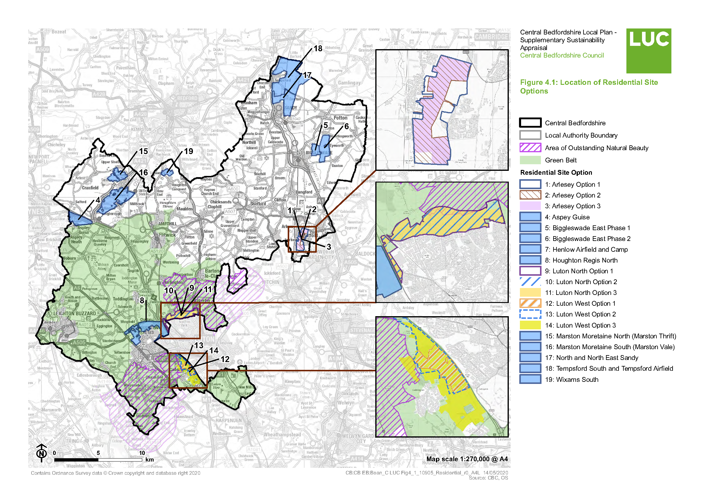

[17] The relationship between Green Belt and the identity of local communities is explained in Appendix A: Baseline Information.
[18] Arlesey Option 1, Arlesey Option 2, Arlesey Option 3, Biggleswade East Phase 2, Luton North Option 1, Luton North Option 2, Luton North Option 3, Luton West Option 1, Luton West Option 2, Luton West Option 3 and Wixams South.
[19] Arlesey Option 1, Arlesey Option 2, Arlesey Option 3, Luton North Option 1, Luton North Option 2, Luton North Option 3, Luton West Option 3, Marston Moretaine South (Marston Vale) and Henlow Airfield and Camp.
[20] Biggleswade East (Phase 2), Henlow Airfield and Camp, Luton North Option 2, Luton North Option 3, Luton West Option 1, Luton West Option 2, Luton West Option 3, Tempsford South and Tempsford Airfield, Houghton Regis North and North and North East Sandy.
[21] Arlesey Option 1, Arlesey Option 2, Arlesey Option 3, Aspley Guise, Biggleswade East Phase 1, Marston Moretaine North (Marston Thrift) and Wixams South.
[22] Arlesey Option 1, Arlesey Option 2, Arlesey Option 3, Aspley Guise, Biggleswade East Phase 1, Biggleswade East Phase 2, Henlow Airfield and Camp, Marston Moretaine North (Marston Thrift), Marston Moretaine South (Marston Vale) and Wixams South.
[23] Luton North Option 1, Luton North Option 2, Luton North Option 3, Luton West Option 1, Luton West Option 2, Luton West Option 3, Tempsford South and Tempsford Airfield, and North and North East Sandy.
[24] JBA Consulting (August 2018) Water Cycle Study Stage 2 Final Report
[25] Arlesey Option 1, Arlesey Option 2, Arlesey Option 3, Aspley Guise, Luton North Option 1, Luton North Option 2, Luton North Option 3, Luton West Option 3, Marston Moretaine North (Marston Thrift), Marston Moretaine South (Marston Vale), Wixams South, Houghton Regis North and North and North East Sandy.
[26] Biggleswade East Phase 1, Luton West Option 1 and Luton West Option 2.
[27] The relationship between Green Belt and the identity of local communities is explained in Appendix A: Baseline Information.
[28] JBA Consulting (August 2018) Water Cycle Study Stage 2 Final Report


