Sustainability Appraisal - Supplementary Report [EXAM 115/115B]
Chapter 5
Supplementary SA Findings: Stage 2
5.1 This chapter presents the second stage of the Supplementary SA work for the Central Bedfordshire Local Plan. The first stage of work presented in the previous chapter involved examining different sets of strategic options (including site options) individually. This second stage builds on that work and draws together the various strands of the SA, considering the key decisions to be made by CBC in terms of the spatial strategy. Information is also provided in this chapter about CBC's reasons for selecting or rejecting the various strategic site options in the submitted Local Plan.
SA work undertaken previously on Areas A-D
5.2 As described in Chapter 2 and Appendix C, the Regulation 19 SA report included an appraisal of Areas A-D. Those four areas were identified by CBC early on in the plan-making process, prior to the Regulation 18 stage. They are not intended as distinct alternatives – clearly it would not be reasonable for all new development to be allocated in just one of these areas. Instead, they are identified as distinct areas within Central Bedfordshire which can be considered separately to help guide plan-making.
5.3 The characteristics of these areas are described in Table 5.1 below. The areas are mapped in Figure 5.1 at the end of this chapter.
Table 5.1: Characteristics of Areas A-D
|
Area |
Description |
|
A: South & West/ M1 Corridor |
This area is heavily constrained by the Green Belt and Chiltern AONB designations. Major sites to the north of Houghton Regis are under development and extensive growth is underway at Leighton Linslade. Smaller settlements generally have limited capacity to grow, although there may be possibilities along major transport routes such as the Midland Main Railway Line. Overall, the Council identified some growth potential primarily to serve the needs of Luton & Dunstable, depending upon the justification for release of Green Belt. |
|
B: East/ A1 corridor |
The broad corridor running north-south along the A1 and the East Coast Main Railway Line is well served with regard to transport and there is the potential for significant upgrades. At Sandy, there is the potential to benefit from the interchange between north-south and east-west links and to attract business growth along the Oxford to Cambridge corridor. Overall, the Council identified potential for major growth on large sites with good infrastructure. |
|
C: East/ West corridor |
This area in the north of CBC includes an important section of the Oxford to Cambridge corridor with its advanced R&D and higher education centres. Future upgrading of the strategic transport network could support access and economic opportunities but the timing and commitment of further investment is uncertain. Overall, the Council identified some growth potential depending upon infrastructure and viability of large sites. |
|
D: Central section |
The central part of the CBC area is characterised by small towns and villages with very limited potential to upgrade infrastructure such as roads. Therefore, overall the Council found only limited potential for growth. |
5.4 As noted in Chapter 2, no supplementary SA work has been carried out in relation to Areas A-D. The most up-to-date SA findings for these four areas are therefore those that were presented in the Regulation 19 SA Report, which are summarised below.
Table 5.2: SA findings for Areas A-D
|
SA objective |
Areas for potential development growth |
|||||||
|
A (South & West/M1 corridor) |
B (East/A1 corridor) |
C (East/West corridor) |
D (Central section) |
|||||
|
++? |
++? |
++? |
+? |
||||
|
--? |
? |
+ |
? |
+ |
? |
+ |
? |
|
+? |
+? |
+? |
+? |
||||
|
+? |
++? |
++? |
+? |
||||
|
++? |
+? |
++? |
0? |
||||
|
0? |
-? |
-? |
-? |
||||
|
+? |
++? |
++? |
0? |
||||
|
0? |
0? |
0? |
0? |
||||
|
0? |
0? |
0? |
0? |
||||
|
0? |
0? |
0? |
0? |
||||
|
- |
- |
- |
- |
||||
|
0? |
0? |
0? |
0? |
||||
|
- |
- |
- |
- |
||||
|
0? |
0? |
0? |
0? |
||||
5.6 At this strategic level of assessment, there was considerable uncertainty in the SA findings since the likely effects depend upon the scale, nature and location of proposed development within each Area, as well as the possibilities for implementing mitigation measures.
SA objective 1: To ensure that the housing needs of all residents and communities are met
5.7 Areas A, B and C are likely to have significant positive effects on SA objective 1. All four Areas could provide an appropriate mix of types of housing but this is more likely to be deliverable through the medium to larger-scale growth that could be delivered in Areas A, B and C. Positive effects in Area D would be minor as growth potential there is small-medium scale.
SA objective 2: To maintain and enhance community and settlement identities
5.8 Development in Area A could have significant negative effects on the first part of SA objective 2, as a result of the loss of Green Belt land and the potential for coalescence of existing settlements. Development in the other three Areas would avoid the Green Belt, so minor positive effects were identified. All four Areas have the potential for either positive or negative effects on the second part of this SA objective (integration and the identity of a settlement or community). Effects will depend upon the sensitivity of the settlement/community and the scale and design of the development.
SA objective 3: To improve accessibility to services and facilities
5.9 All four Areas are likely to have minor positive effects on SA objective 3. Although large development sites (including new villages or extensions to settlements) have the potential to put strain on existing services, they also have the greater potential for positive effects through early, creative masterplanning with the scale and scope to provide sustainable community infrastructure thus mitigating potential negative effects and potentially benefitting the area.
SA objective 4: To support the economy and ensure that there are suitable opportunities for employment
5.10 All four Areas are likely to have positive effects on SA objective 4. Potential significant positive effects were identified for Area C which has close links to Milton Keynes and is well-connected with the improved A421, M1 and the planned upgrading for the East West Rail between Oxford and Cambridge. Area B also has the potential for significant positive effects due to the location of the A1 corridor through this area and the planned upgrading of the East West Rail. Area A offers strong opportunities to support and enhance the vitality and viability of Dunstable and Luton town centres.
SA objective 5: To improve the health and wellbeing of communities and reduce inequalities
5.11 Area A could have a significant positive effect on SA objective 5 as it includes areas of higher deprivation around Houghton Regis and Luton which new development could help to address. Health would also be benefited by GI provision which should be better addressed by the larger-scale development possible in Areas A-C. Since growth potential for Area D would be small-medium sized, there may be fewer opportunities for delivering GI enhancements.
SA objective 6. To maintain and improve the existing highway network and reduce associated indirect impacts on air quality and greenhouse gas emissions
5.12 There is some potential for growth along the major transport corridor following the M1, A5 and the railway with likely negative effects in Area A but mitigation may be achieved by ensuring that new development is located where there is existing capacity, with potential neutral effects resulting. Minor negative effects are likely to result from Areas B, C and D as a result of increased pressure on the highways network in those areas. The A1 corridor running through Area B is a strategic location for the warehousing industry with good, fast access to the national/international road network and is important to maintain. Area C is well-connected with the improved A421, the M1 and the planned section upgrade for East West Rail60 between Oxford and Cambridge. There is the potential for major development, including new settlements, to contribute to further improvements and ensure the continuing capacity of the strategic road and rail networks; although there is uncertainty at this stage. Larger developments are more likely to be able to support funding for upgrading the strategic road network. The smaller-medium scale developments indicated for Area D are less likely to support the potential to upgrade roads.
SA objective 7: To encourage a demonstrable modal shift to more sustainable forms of transport and reduce the need to travel
5.13 Area A is well-connected to the Midland Main railway line and smaller-medium sized developments at locations such as Ampthill, Flitwick, Westoning and Harlington, along well-connected public transport routes could encourage modal shift with positive effects. Larger scale developments with major opportunities to promote sustainable transport are only likely to be possible adjacent to Luton and to help meet the housing needs of Luton Borough. Larger scale developments indicated for Areas B and C have the scope for effective design and implementation of sustainable transport modes – cycling and walking – with the potential for significant positive effects. Smaller-medium scale development indicated for Area D limits possibilities with likely neutral effects.
SA objective 8: To maximise the potential for energy efficiency, reduce greenhouse gas emission and ensure that the built, natural environment and its communities can withstand the effects of climate change
SA objective 9: To minimise the demand for water and maintain or improve water quality
5.14 All development has the potential for high energy and water efficiencies but generally, the scale and scope of the larger developments, especially new villages/settlements, offers potential possibilities for exemplar design and construction.
SA objective 10: To reduce the risk of flooding from all sources
5.15 The Regulation 19 SA report noted that a Development Management Policy on Flood Risk was being drafted for the Local Plan in line with Government guidance. This will provide mitigation measures. Larger developments can have the scale and scope to provide creative design and potentially contribute to resolving existing flood risk issues. No differences were identified in the SA between Areas A-D for these SA objectives.
SA objective 11: To protect and conserve soil
5.16 Minor negative effects were identified for all four Areas. All development will take land and the soil resource will be lost with permanent negative effects. However, it is possible to avoid the best and most versatile agricultural land.
SA objective 12: To protect, enhance and manage biodiversity & geodiversity
5.17 The Regulation 19 SA report noted that Development Management Policies on Green Infrastructure, Enhancing Ecological Networks and Nature Conservation were being drafted for the Local Plan and these will help to avoid important assets to avoid negative effects on this SA objective. The SA did not identify variations in the likely effects on biodiversity and geodiversity of development in the four Areas as these will depend on the specific location of developments.
SA objective 13: To protect and enhance the landscape and townscape
5.18 All development has the potential for negative effects on landscape and townscape. The SA noted that Development Management Policies on Landscape Character and Value are being drafted for the Local Plan and these should reduce the extent of negative effects. No differences were identified in the SA between Areas A-D for these SA objectives.
SA objective 14. To ensure the protection and enhancement of heritage assets, the historic environment and its setting
5.19 The Regulation 19 SA report noted that a Development Management Policy on the Historic Environment was being drafted for the Local Plan and that this will help to avoid important assets to avoid negative effects on this SA objective. The SA did not identify variations in the likely effects of development on the historic environment in the four Areas as these will depend on the specific location of developments.
5.20 Area C performed the best of the four Areas in the SA, with four potential significant positive effects identified. The next best performing was Area B, with three potential significant positive effects, followed by Areas A and D with two and zero likely significant positive effects identified respectively.
5.21 Area D performed poorest of all the Areas in the SA, as the area offers the potential only for smaller-scale development which would not deliver, or provide access to, as wide a range of services, facilities and infrastructure. Conversely, development in Area C could be larger-scale, and would have good potential in terms of employment and the economy due to the focus in that area of research and development activities. The area is also well-connected in transport terms. The Green Belt in Area A is a significant constraint and that was the only Area which had a potential significant negative effect associated with it.
Options for the distribution of development growth
5.22 The SA findings for the six options for the distribution of development growth were presented in Chapter 4. In summary, the best performing options were Option 2 (larger new settlements), Option 5 (growth around sustainable transport hubs), and Option 6 (urban extensions). The poorest performing options in the SA were Option 3 (village extensions) and Option 4 (growth around strategic roads). Option 1 (smaller new settlements) fell in the middle of these two groups of options in terms of the likely sustainability effects. This suggests that while villages may be able to make some provision, CBC should be looking largely towards other distribution types, particularly 2, 5 and 6, and then 1, when considering alternative options for the greatest contribution to meeting development needs.
5.23 The SA findings for the strategic residential site options were presented in Chapter 4. This section considers which of those site options falls within each of the development types referred to above, and which of Areas A-D they are located in. This analysis helps to identify alternative approaches that CBC could take to selecting sites for allocation.
5.24 Table 5.3 below lists the residential site options in each of Areas A-D and shows which of the distribution options they are classified as, as well as how many homes they could accommodate. The sites that are currently allocated in the submitted version of the Local Plan are shaded in grey.
Table 5.3: Alternative site options matrix
|
Area |
Site options |
Distribution type(s) |
Number of homes |
|
A |
Luton North Option 1 |
4, 6 |
Up to 4,000 |
|
Luton North Option 2 |
4, 6 |
Up to 3,100 |
|
|
Luton North Option 3 |
4, 6 |
Up to 3,600 |
|
|
Luton West Option 1 |
1, 4, 6 |
Up to 2,000 |
|
|
Luton West Option 2 |
1, 4, 6 |
Up to 3,500 |
|
|
Luton West Option 3 |
1, 4, 6 |
Upwards of 4,600 |
|
|
Houghton Regis North |
4, 6 |
Between 4,150 and 5,150 |
|
|
B |
Arlesey Option 1 |
4, 5, 6 |
Up to 2,000 |
|
Arlesey Option 2 |
4, 5, 6 |
Up to 2,000 |
|
|
Arlesey Option 3 |
4, 5, 6 |
Up to 1,800 |
|
|
Biggleswade East Phase 1 |
1 |
Up to 1,500 |
|
|
Biggleswade East Phase 2 |
2 |
Up to 5,500 |
|
|
North and North East Sandy |
4, 5, 6 |
4,750 |
|
|
Tempsford South and Tempsford Airfield |
2 |
Up to 10,000 |
|
|
C |
Aspley Guise |
4, 6 |
Up to 3,000 |
|
Marston Moretaine North (Marston Thrift) |
1, 4 |
Up to 1,500 |
|
|
Marston Moretaine South (Marston Vale) |
1, 4, 5 |
Up to 5,000 |
|
|
Wixams South |
3 |
Up to 650 |
|
|
D |
Henlow Airfield and Camp |
1, 3[29] |
1,000 |
Table 5.4: Key to distribution types
|
Number |
Type of distribution |
|
1 |
New settlement (village scale) – 1,500-5,000 new homes |
|
2 |
New settlement (town scale) – more than 5,000 new homes |
|
3 |
Village extensions – especially those with services and facilities |
|
4 |
Growth around strategic roads |
|
5 |
Growth around sustainable transport hubs |
|
6 |
Urban extensions assumed to be 1,500-4,000 |
5.26 The following sections consider the key decisions to be made by CBC in each area, with respect to the alternative residential site options. The site-level SA findings are considered alongside the SA findings for both the four areas and the different development types. Bearing in mind, the preference shown in SA terms for looking towards distribution types other than Option 3 (village extensions), (as explained in paragraph 5.21), these sections focus on the strategic sites.
5.27 At the end of each section, the sites that are allocated in the submitted Local Plan in that area are identified and the reasons for CBC's decision making at that time are given. Where CBC proposes to make changes to allocations within the Local Plan this is noted and the reasons given. This information has been provided by CBC and is included in this report in order to meet the requirement of the SEA Regulations to provide reasons why certain options are selected and others rejected.
Area A: South & West/ M1 Corridor
5.28 This area is characterised by the Chilterns AONB and Greensand Ridge Nature Improvement Area (NIA), both of which have valued habitats and landscapes which are existing environmental assets. The SA has shown that the area can deliver the social and economic benefits associated with larger-scale development, but that the Green Belt is a planning constraint.
5.29 The constrained nature of neighbouring Luton Borough means that it isn't possible to meet its housing needs within the Borough boundaries. CBC and North Hertfordshire District Council have both committed to meeting the remaining unmet need (Position Paper on Luton HMA Housing Distribution (CBC Duty to Cooperate Statement)). Through Duty to Co-operate discussions, CBC has committed to providing 7,350 homes, preferably within the part of Central Bedfordshire that falls within the Luton Housing Market Area (HMA) to contribute to Luton's unmet need (but with the acknowledgement that locations required testing within the Local Plan), and to providing the housing for Luton as close to Luton as possible
5.30 Table 5.5 below summarises the SA findings for the seven strategic residential site options that have been considered in Area A. Six of these options are alternative versions of development at Luton North and Luton West.
Table 5.5: SA findings for strategic site options in Area A
|
SA objectives |
Site options |
|||||||
|
Luton North Option 1 |
Luton North Option 2 |
Luton North Option 3 |
Luton West Option 1 |
Luton West Option 2 |
Luton West Option 3 |
Houghton Regis North |
||
|
++ |
++ |
++ |
++ |
++ |
++ |
++ |
|
|
Green Belt |
-- |
-- |
-- |
-- |
-- |
-- |
-- |
|
Settlement identities |
- |
- |
- |
- |
- |
- |
-? |
|
|
++ |
++ |
++ |
++? |
++? |
++? |
++ |
|
|
Employment support |
++ |
+ |
+ |
+ |
+ |
+ |
+ |
|
Town centres |
+ |
+ |
+ |
+? |
+? |
+? |
+ |
|
|
Regeneration |
+ |
+ |
+ |
+? |
+? |
+? |
++? |
|
Green infrastructure |
++ |
++ |
++ |
++ |
++ |
++ |
++ |
|
|
-? |
-? |
-? |
--? |
--? |
--? |
--? |
|
|
+ |
+ |
+ |
+ |
+ |
+ |
+ |
|
|
+? |
+? |
+? |
+? |
+? |
+? |
+? |
|
|
0? |
0? |
0? |
0? |
0? |
0? |
0? |
|
|
0 |
0 |
0 |
0 |
0 |
0 |
0 |
|
|
Agricultural land classification |
--? |
--? |
--? |
--? |
--? |
--? |
--? |
|
Previously developed land |
0 |
0 |
0 |
0 |
0 |
0 |
0 |
|
|
+/-? |
+/-? |
+/-? |
+/-? |
+/-? |
+/--? |
+/-? |
|
|
--? |
-? |
-? |
-? |
--? |
--? |
+? |
|
|
-? |
-? |
-? |
0? |
0? |
-? |
-? |
|
5.32 Given that the site at Houghton Regis North already has planning permission, the key decisions to be made by CBC in Area A are based around the site(s) adjacent to Luton. As well as considering the relative performance in SA terms of the areas to the north and west of the town, the three alternative options in each location need to be compared to one another.
5.33 Overall, Luton North performs better in the SA than Luton West. All three of the alternative Luton North options are expected to have either three or four significant positive effects on the SA objectives and either two or three significant negative effects. In comparison, the Luton West site options would each have three significant positive effects and between three and five significant negative effects. Although Luton North Option 1 performs better than all the other Luton options with respect to SA objective 4 (employment), it would have a significant negative effect on SA objective 13 (landscape) along with Luton West Options 2 and 3. The three Luton West options would have a significant negative effect on SA Objective 6 (highways and air quality). Comparing the three alternative options at Luton North, Options 2 and 3 perform slightly better in SA terms than Option 1 as the negative effects on the landscape are not considered likely to be significant under Options 2 and 3. This reflects the fact that Option 1 was reduced in size to create the alternative Options 2 and 3, in response to concerns expressed previously by consultees in relation to the impacts of Option 1 on the Chilterns AONB and heritage assets.
5.34 If neither Luton North or Luton West were to be allocated, and the housing required for Luton were to be delivered at strategic sites elsewhere within Central Bedfordshire, it would not be meeting the identified needs of Luton in terms of location, which would have negative effects for SA objective 1 (housing). That approach would also be likely to result in higher levels of car use amongst residents commuting to and from Luton for work and other activities, which would have negative effects on SA objectives 6 (highways and air quality), 7 (sustainable transport) and 8 (energy and climate change). However, providing the housing outside of Area A could help to avoid negative effects on SA Objective 2 (Green Belt) and SA objective 13: (landscape) as the presence of the AONB within Area A means that it is the most sensitive part of Central Bedfordshire in landscape terms.
5.35 An alternative approach of allocating both Luton North and Luton West, albeit at the smallest scale, could also have negative effects in terms of SA objective 1 (housing) as a large amount of development would be focussed in Area A and the amount of housing delivered in other parts of Central Bedfordshire may not be adequately distributed to meet needs in other areas. There may also be more likely to be negative cumulative effects on SA objective 13 (landscape) due to the large amount of development to be focussed near to the AONB in two different locations rather than just one. Smaller-scale development at both locations may also mean that neither allocation is large enough to support a full range of services and facilities onsite, meaning that people have to travel more day-to-day – this could have negative effects on SA objective 3 (services and facilities) as well as SA objectives 6 (highways and air quality), 7 (sustainable transport) and 8 (energy and climate change). As shown in Chapter 4, larger new developments and urban extensions tend to perform better in the SA in terms of creating sustainable self-contained communities.
5.36 Conversely, allocating neither Luton North or Luton West and instead relying on development in the villages within Area A to deliver housing for Luton would still mean that levels of car use would be high and access to services, facilities and job opportunities would be relatively poor - the SA findings for the alternative approaches to development (see Chapter 4) showed that village extensions perform poorly in SA terms for these reasons.
5.37 Therefore, the SA findings indicate that the most sustainable approach would be to allocate development at Luton North (either Option 2 or 3). Houghton Regis North performs better than the other Luton options, and the site already has planning permission. Allocation in the Local Plan could present an opportunity to include appropriate criteria in the allocation policy for that site, to ensure that the potential negative effects are mitigated as far as possible and positive effects are maximised.
CBC's reasons for decision making in Area A
The submitted Local Plan allocates a site for development at Luton North (the boundary referred to as Option 1 delivering 4,000 homes and up to 20ha employment). It also includes the site at Houghton Regis North (referred to as sites 1 and 2) as commitments as they already had planning permission.
Growth distribution options
The Council considered various options around the Luton North and West sites, including whether it would be best to allocate one site over the other or whether both or neither could potentially be taken forwards. CBC concluded that allocating both Luton North and Luton West would create an unbalanced strategy, concentrating too much development in one part of the plan area, particularly considering the Green Belt release required and the sensitivities around the AONB. The option of allocating neither site and relying solely on the villages was also rejected. Through the site assessment process CBC concluded that there is insufficient capacity at the villages in Area A to meet Luton's unmet needs and that development at the villages in Areas B-D would locate the housing away from where it is required. This approach would also fail to meet the commitment made through Duty to Co-operate (Position Paper on Luton HMA Housing Distribution (CBC Duty to Cooperate Statement)) to provide the housing for Luton as close to Luton as possible.
CBC concluded that Luton North was preferable to Luton West because it would integrate better with the existing urban area and offers better opportunities for sustainable travel. Luton North would help to fund the link road, which would have wider benefits in terms of removing HGV traffic from the rural road network and reducing rat-running on rural roads through villages to the north. The Council also had concerns about the segregation of Luton West from the built-up area of Luton, the potential for coalescence of existing settlements, and issues surrounding access and topography in that area.
North of Luton options appraisal
Following the submission of the Local Plan, the Inspector requested the preparation of additional evidence to assess the impact of the proposed allocation on landscape and heritage assets and their settings. This evidence demonstrated that the 4,000 home scheme (Option 1 in this appraisal) would have a significant impact on both. As a consequence, the Council proposed the removal of the area to the east of the site termed 'the eastern bowl' from the developable area of the site. The resulting site had a capacity to deliver approximately 3,100 homes (Option 2 in this appraisal). This position was agreed with both Natural England and Historic England. At the Examination hearings, the site promoters presented a further alternative option for 3,600 homes which included some sensitive development on the southern part of the eastern bowl (Option 3 in this appraisal).
Since the close of the hearings the M1-A6 Link Road has been granted consent and the site promoters have prepared an LVIA Addendum that assesses the significant landscape and visual effects of the three site options, in light of this consent. The LVIA Addendum indicates that all options may be considered acceptable for development, subject to their detailed design and mitigation, with the 3,600 home scheme being preferred as it maximises the provision of new market and affordable housing to meet the needs of Luton, whilst still reducing the landscape, visual and character effects on the AONB from the 4,000 home scheme.
The Supplementary SA has appraised the three alternative options for North of Luton and concludes that Options 2 and 3 (3,100 and 3,600 homes respectively) were the best performing and the most sustainable approach to strategic scale growth around Luton, although the conclusions for both options were very similar. The Supplementary SA also considered a range of options at West of Luton, which did not perform as well as these options for the North. The assessment supports the Reg. 19 SA conclusions in relation to the potential negative impacts of allocating both sites (even at the smaller capacities).
Reflecting on the additional evidence and the change in circumstances resulting from the consent of the M1-A6 Link Road, it is the Council's view that there may be some potential for development on land to the south of the link road within the eastern bowl (Option 3), although there are some uncertainties in the absence of a detailed scheme. For this reason, the Council is proposing modifications to the policy that allocates the North of Luton for approximately 3,100 dwellings outside of the eastern bowl, but also allows carefully designed additional development within the southern part of the eastern bowl, subject to detailed landscape and heritage work at the planning application stage demonstrating that any impacts are acceptable or capable of being mitigated. This could take the site total up to 3,600 homes.
This approach allows for flexibility, but additional homes will only be delivered if the environmental impacts are demonstrated to be acceptable. This has potential benefits in terms of the viability of the scheme, which would improve with a higher capacity, and would critically assist in delivering additional housing to meet Luton's unmet market and affordable housing needs.
Houghton Regis North Sites 1 and 2
The two component sites that together comprise the Houghton Regis North option were granted outline planning permission in 2015. The sites were included as allocations in the Local Plan, albeit as commitments to reflect their status, in order to provide a policy framework to inform the preparation and determination of future planning applications.
Small and medium sites
The Supplementary SA re-appraised growth distribution options and concluded that village development comes out least favourably.
The Reg. 19 SA found that restricting growth in Area A due to the Green Belt, was likely to have negative effects for the needs and health of communities in that part of CBC, as well as the cross-boundary needs of Luton Borough. Without growth in Area A, communities would not benefit from the potential revitalisation that new development can provide. In addition, relying solely on strategic sites within Area A could impact on the delivery of much needed homes to meet the needs of Central Bedfordshire and Luton in the short term.
Whilst village growth wouldn't negate the need for a strategic site to be delivered, two medium sites and various small sites were also allocated within the submitted Local Plan.
5.38 The broad corridor running north-south along the A1 and the East Coast Main Railway Line is well served with regards to transport, having access to the East Coast Mainline with enhanced capacity from Thameslink services. Railway stations are located at Arlesey, Biggleswade and Sandy. CBC has identified the potential for major growth on large sites with good infrastructure.
5.39 The preferred corridor for East West Rail was identified after the Local Plan was submitted. It passes to the north of Sandy, offering an interchange with the East Coast Mainline and east west connectivity to the higher order centres of Cambridge, Bedford, Milton Keynes and Oxford.
5.40 The SA confirmed that Area B performs well in terms of the opportunities it presents for larger-scale developments and its good transport links.
5.41 Table 5.6 below summarises the SA findings for the seven site options that were considered in this Area.
Table 5.6: SA findings for strategic site options in Area B
|
SA objectives |
Site options |
|||||||
|
Arlesey Option 1 |
Arlesey Option 2 |
Arlesey Option 3 |
Biggleswade East Phase 1 |
Biggleswade East Phase 2 |
Tempsford South and Tempsford Airfield |
North and North East Sandy |
||
|
++ |
++ |
++ |
++ |
++ |
++ |
++ |
|
|
Green Belt |
0 |
0 |
0 |
0? |
0? |
0 |
0 |
|
Settlement identities |
- |
- |
- |
+ |
- |
--? |
-? |
|
|
++ |
++ |
++ |
++ |
++ |
++ |
++? |
|
|
Employment support |
0 |
0 |
0 |
+? |
+ |
+ |
+? |
|
Town centres |
+ |
+ |
+ |
+ |
+ |
+ |
+ |
|
|
Regeneration |
0 |
0 |
0 |
0 |
0 |
+? |
+? |
|
Green infrastructure |
++ |
++ |
++ |
++ |
++ |
++ |
++ |
|
|
0? |
0? |
0? |
0? |
0? |
-? |
--? |
|
|
+ |
+ |
+ |
+ |
+ |
+? |
+ |
|
|
+? |
+? |
+? |
+? |
+? |
+? |
+? |
|
|
0? |
0? |
0? |
0? |
0? |
0? |
0? |
|
|
0 |
0 |
0 |
-? |
-? |
0 |
0 |
|
|
Agricultural land classification |
--? |
--? |
--? |
--? |
--? |
--? |
--? |
|
Previously developed land |
0 |
0 |
0 |
0 |
0 |
+ |
0 |
|
|
++/-? |
+/-? |
+/-? |
-? |
-? |
+/-? |
+/-? |
|
|
+/- |
+/- |
+/- |
+? |
+? |
-? |
-? |
|
|
-? |
-? |
-? |
0? |
--? |
--? |
-? |
|
5.43 In SA terms, Arlesey is the best performing location in Area B, with Option 1 performing marginally better than Options 2 and 3. Biggleswade East Phase 1 also performs well, and considerably better than Biggleswade East Phase 2. Tempsford South and Tempsford Airfield is the poorest performing site in Area B. North and North East Sandy falls somewhere in the middle, similar to Biggleswade East Phase 2.
5.44 The Arlesey site options perform well because they are of a large enough scale to provide some services and facilities onsite but are also close to the good range of existing and committed services and facilities within Arlesey itself. Development nearby would support the vitality and viability of Arlesey town centre. The three Arlesey options also offer the opportunity for the delivery of a new country park, although this would be more certain under Option 1. This would benefit biodiversity and health.
5.45 The very large scale of development that could occur at Biggleswade East Phase 2 means that effects might have been expected to be more positive than are in fact indicated through the SA, given that the SA findings presented in Chapter 4 showed that larger scale development generally performs well in sustainability terms. Indeed, the option does perform well in terms of access to services and transport links. However, the SA highlights the sensitivity of the site in terms of the historic environment and the presence of designated heritage features within the boundary. The site is also on Grade 2 agricultural land, a large area of which would be lost. The large-scale development could also have negative effects on the setting of nearby settlements including Sutton and Dunton. In contrast, Biggleswade East Phase 1 is of a scale and location that would be easier to integrate with the existing urban area of Biggleswade. The benefits of development near to Biggleswade for both options include proximity to services and good transport links.
5.46 Similar to Biggleswade East Phase 2, Tempsford South and Tempsford Airfield offers an opportunity for a very large-scale development which would offer many of the sustainability benefits associated with larger developments that were highlighted in Chapter 4. The development should operate as a standalone settlement and would offer the critical mass needed to provide a good range of services and facilities, and its scale also means that transport links should be able to be provided to link with the station at Sandy. However, the SA highlights the potential for settlement coalescence between Everton and Sandy and the site is largely greenfield Grade 2 agricultural land which would be lost.
5.47 The site at North and North East Sandy performs well in relation to several of the SA objectives. It is again at the larger end of the scale in terms of the size of the strategic options which means it would be able to incorporate services and facilities and transport links. It is well-connected to existing transport links and would be developed as an extension to Sandy, providing good access to the railway station there and existing services and facilities, although it is noted that the railway station would be located some distance from certain parts of this large site. However, its proximity to the A1 means that it could have adverse impacts on traffic in that area and contribute to poor air quality at the AQMA already declared at Sandy. It is also possible that there could be competition between services and facilities to be provided as part of the development and the existing town centre.
5.48 The SA therefore points to Arlesey being the most sustainable location for development in Area B, with Option 1 performing slightly better than Options 2 and 3.
CBC's reasons for decision making in Area B|
The submitted Local Plan allocates the East of Arlesey site for 2,000 homes and a country park (Arlesey Option 1 in this appraisal) as well as Biggleswade East Phase 1 (Biggleswade Option 1 in this appraisal).
In the Regulation 19 SA Area B performed the best of the four areas. The Supplementary SA re-presented the appraisal of the four areas which showed that Area B performs well in terms of the opportunities it presents for larger-scale developments and its good transport links.
East of Arlesey
Evidence shows that Arlesey is a sustainable location for additional, and quite significant, growth due to its highly sustainable location, in close proximity to a mainline, Thameslink, railway station with capacity for additional passenger numbers, and its close proximity to the A1. The settlement has been subject to piecemeal development in the past and East of Arlesey, in combination with an existing commitment, Chase Farm, provide opportunities to comprehensively deliver additional services and facilities for new and existing residents as well as, critically, the delivery of a relief road to resolve existing congestion issues on the High Street. The allocation would also deliver a new country park, equating to approximately 97ha, that would be located to the east of the site, which offers significant benefits to new and existing communities, whilst also ensuring coalescence does not occur between Fairfield and Arlesey.
Following the Examination hearings, the Inspectors raised concerns about the scale of growth and the risk of coalescence between Arlesey and Fairfield. The Council has worked collaboratively with the site promoters to determine whether all alternative options for this site have been considered, and whether there are opportunities to reduce the scale of development or propose modifications to further mitigate any potential coalescence. The Supplementary SA appraises three alternative options, of which Option 1 (the site as submitted) performs slightly better than Options 2 and 3.
Option 1 performs better due to the increased level of certainty it provides in terms of the country park. Including all this area within the red line boundary ensures the council can control the use of this land as part of the policy, and any subsequent planning application. Modifications to the policy wording are proposed to ensure coalescence is minimised; making clear built development will only be permitted up to the gas pipeline / relief road (no further east), and defining the character and function of different areas of the country park – ensuring some areas are left in agricultural use with no public access, for example.
East of Biggleswade
Biggleswade East (Phase 1) was allocated in the submitted Local Plan but has since been afforded outline planning permission. Biggleswade East (Phase 1) will provide its own day to day facilities and will operate as a stand-alone village, but is located in close proximity to Biggleswade, which offers the potential for sustainable access to higher order facilities and the mainline railway station. Evidence has confirmed impacts on the A1 and highway network can be mitigated and an upgrade to the A1 south roundabout has been agreed with Highways England
The site is to be accessed via an existing roundabout on Baden Powell Way. A neighbouring landowner controls land between the site and Baden Powell Way and a commercial agreement will need to be made between the site promoter and the owners of the adjacent site. The Council considers that an agreement can be reached and that this isn't a barrier to the delivery of the site. There was uncertainty over power supply at the time the submitted Local Plan was written; however following the allocation of the site in the Local Plan it became apparent that there is a need for a new Super Grid to supply power to future new development in Biggleswade and the surrounding area. This Super Grid is being funded through the secured Housing Infrastructure Fund (HIF) funding.
Biggleswade East (Phase 1) was included as an allocation in the submitted Local Plan. Now it has planning permission, the Council has proposed a modification to include it as a strategic commitment instead. This will provide a policy framework to inform the preparation and determination of future planning applications.
Alternative options:
These two sites performed the best in SA terms, but the following alternative options were also discounted for various other reasons:
Tempsford and Tempsford Airfield
Development at Tempsford was assessed for up to 10,000 homes. Whilst this would make a huge contribution towards meeting housing needs within CBC, this site is in the corridor where the route alignment for East West Rail is currently being considered, as such, it could prejudice the delivery of this critical infrastructure. The Expressway Route was also unknown at the time of allocation. Due to the scale of growth, upgrades to the A1(M) would likely be required to accommodate this capacity – there are no plans for this at present. A smaller site/capacity option was considered, but the site would not have access to a railway station and would be based around a small existing settlement with limited facilities. The large site (combining two parcels) would have the critical mass to deliver necessary infrastructure, enabling a stand-alone settlement and contribution to the delivery of EWR. A larger scheme is most appropriate to consider via an early partial review once key infrastructure decisions have been made.
North and North East Sandy
There are similar circumstances for North of Sandy, which is also in the East West Rail corridor. Access is also an issue, as vehicles would have to pass through an existing residential area. Half the site is located to the east of the railway line, separated from the rest of the settlement, with limited points of access that couldn't accommodate a significant number of vehicles. The site would also require a new/upgraded access across the railway line. Even a smaller site to the north of Sandy (also submitted separately for consideration) has the same issues around access and distance from the main services and facilities (town centre and railway station) to the south of the settlement. Walking distance from the station and town centre to the northern part of the site is over 30mins.
Biggleswade East (Phase 2)
Biggleswade East (Phase 2) was not considered an appropriate site to allocate at this time due to its potential impact on the capacity of the A1(M), with no current mitigation identified to resolve that in the longer term. A smaller scale of growth was considered and has been allocated (East of Biggleswade Phase 1).
All of these sites require major infrastructure decisions to be made, many of which are currently being considered as part of the growth ambitions for the Oxford-Cambridge Arc. As such, they will be subject to further consideration via the early partial review of the plan,
Small and medium scale sites
Some smaller-scale sites in those smaller settlements which have capacity have also been allocated within the plan. Bearing in mind the preference for other distribution types shown, alongside individual site assessments, it is not considered development options at this scale could negate the need for either of these strategic sites.
5.49 This area of Central Bedfordshire is an important economic area with advanced research and development at Cranfield Technology Park and Millbrook Proving Ground and close links with Milton Keynes. The area is well-connected with the upgraded A421 and the M1 as well as the planned Western Section upgrade of East West Rail between Oxford and Bedford. Further improvements to transport infrastructure should be provided by the forthcoming Expressway, the route of which is not yet known.
5.50 The area has a history as a location for growth - it was designated as a growth area in the East of England Regional Spatial Strategy and Milton Keynes and South Midlands Sub Regional Strategy and this is reflected in the adopted Mid Bedfordshire Core Strategy.
5.51 The SA of the four Areas highlighted the benefits of larger-scale development which can be delivered in Area C, alongside the good sustainable transport potential here.
5.52 Table 5.7 below summarises the SA findings for the four site options that were considered in this Area.
Table 5.7: SA findings for strategic site options in Area C
|
SA objectives |
Site options |
||||
|
Aspley Guise |
Marston Moretaine North (Marston Thrift) |
Marston Moretian South (Marston Vale) |
Wixams South |
||
|
++ |
++ |
++ |
++ |
||
|
Green Belt |
0 |
0 |
0 |
0? |
|
Settlement identities |
-? |
--? |
--? |
- |
|
|
++ |
++? |
++ |
++ |
|
|
Employment support |
0 |
0 |
++ |
0 |
|
Town centres |
+ |
+? |
+ |
+ |
|
|
Regeneration |
0 |
0 |
0 |
0 |
|
Green infrastructure |
++ |
++ |
++ |
++ |
|
|
0? |
-? |
-? |
0? |
|
|
++ |
+ |
++ |
+ |
|
|
+? |
+? |
+? |
+? |
|
|
0? |
0? |
0? |
0? |
|
|
0 |
0 |
0 |
0 |
|
|
Agricultural land classification |
--? |
--? |
--? |
--? |
|
Previously developed land |
0 |
0 |
+ |
0? |
|
|
-? |
+/-? |
+/-? |
+/-? |
|
|
+? |
+? |
+? |
+? |
|
|
-? |
-? |
-? |
-? |
|
5.53 Marston Moretaine South (Marston Vale) performs best of all the site options across Central Bedfordshire, not just within Area C. Five potential significant positive effects are identified for that site compared to three or four for the other sites in this Area. The site would deliver a large new settlement of up to 5,000 homes, which offers the opportunity to capitalise on the sustainability benefits of this scale of development that were highlighted in Chapter 4. The development would be of a scale to provide a wide range of services and facilities onsite, building on the range already available at nearby Marston Moretaine and Lidlington. The development would incorporate a large amount of employment land, which would combine with the good access that the site provides to employment opportunities elsewhere. The site is well-located in relation to existing green infrastructure and sustainable transport links and again offers good opportunities to incorporate new provision as part of the development, including the provision of 30% tree canopy cover in accordance with the aspirations of the Forest of Marston Vale and a section of the Bedford and Milton Keynes Waterway. While the site is in an area of high-quality agricultural land, this is also the case for the other site options in Area C. However, this site is in an area with a history of mineral extraction and so offers an opportunity to remediate any despoiled land.
5.54 Marston Moretaine North (Marston Thrift) performs less well in the SA compared to Marston Moretaine South (Marston Vale). The smaller scale of that option means that the opportunities to develop a relatively self-contained new settlement would be limited and the same extent of employment provision would not be made. Both site options would lead to some degree of coalescence between settlements in the area.
5.55 The proximity of the two Marston Moretaine sites means that if both were to be allocated, this would concentrate a significant amount of development in that area. This could result in similar negative cumulative effects as described previously in relation to Luton North and Luton West, focussing too much housing in one part of Central Bedfordshire with the associated impacts on the road network and landscape. Cumulative impacts on nearby settlement identities would also be significantly negative under that approach.
5.56 Wixams South and Aspley Guise are similar in terms of their SA performance, performing relatively well against the SA objectives as a whole, better than Marston Moretaine North (Marston Thrift), but not as well as Marston Moretaine South (Marston Vale). Neither site would make employment provision. Wixams South is the smallest of the strategic residential site options, with only 650 homes; therefore it would not offer the same opportunities as larger sites to incorporate new services, facilities and employment opportunities.
5.57 The SA findings overall indicate that Moretaine South (Marston Vale) is the most sustainable site option to take forward in Area C.
CBC's reasons for decision making in Area C
The submitted Local Plan allocates one strategic site in Area C, Marston Moretaine South (Marston Vale).
Marston Vale has been favoured by CBC for allocation as it delivers a self-contained, comprehensive, mixed-use development that provides new and upgraded services and facilities to support new and existing communities. It delivers the strategic priorities of the Forest of Marston Vale and crucially it also delivers a section of the Bedford and Milton Keynes Waterway. It's assessment in the SA reflects this, with it performing the best of all strategic site options considered, not just within Area C but across CBC as a whole.
The development can be sensitively designed as a series of villages, enabling mitigation/separation from existing towns and villages, but also delivering new and upgraded services and infrastructure. It offers connectivity to larger settlements in the area (Marston Moretaine and Lidlington) and Ridgmont station on East West Rail.
In terms of considering the other options, there are a number of reasons why these other sites weren't allocated, over and above those identified by the SA:
Marston Mortaine North (Marston Thrift)
In terms of Marston Thrift, the SA is clear that it performs less well than the adjacent Marston Vale due to its smaller scale, limiting self-containment and the impacts on settlement identities being more significant. The allocation of both sites was considered, but it was concluded this would result in an unbalanced strategy, as described for options in Area A, with increased and unacceptable cumulative impacts on nearby settlements, the road network and the landscape.
Aspley Guise
This site was prevented from being allocated due to it being within the potential alignment for the Expressway. The Council was aware the route would connect at J13, meaning allocation of this site could have prejudiced its delivery. This site could only be considered once strategic decisions around infrastructure in the Oxford-Cambridge Arc were further down the line. As such, the site would be considered as part of an early partial review.
Wixams South
Wixams South was identified as a medium scale allocation in the Local Plan (HAS27) and has since been granted outline planning permission.
Some smaller-scale sites in those smaller settlements which have capacity have also been allocated within the plan. Bearing in mind the preference for other distribution types shown, alongside individual site assessments, it is not considered development options at this scale could negate the need for strategic sites.
5.58 The submitted Local Plan notes that the settlement pattern and constrained infrastructure in Area D limit the options for strategic-scale growth. This area has been subject to a large number of allocations through the historical plan making process. It has also had a large number of recent permissions as a result of speculative development. This has led to piecemeal development which does not allow for a holistic approach to the delivery of new services and infrastructure.
5.59 The SA of Area D showed that it is generally a less sustainable location for development compared to Areas A-C due to the limited potential for large-scale development. The appraisal of alternative approaches to development growth reinforced this, showing that smaller new settlements or village extensions provide less good opportunities for incorporating services, facilities and job opportunities and therefore do not tend to result in the more self-contained settlements resulting from larger new developments. Area D is also less well-connected than the other areas in transport terms.
5.60 Table 5.8 below presents the SA scores for the only site option in Area D, Henlow Airfield and Camp.
Table 5.8: SA findings for strategic site option in Area D
|
SA objectives |
Site option |
|
|
Henlow Airfield and Camp |
||
|
++ |
|
|
Green Belt |
0 |
|
Settlement identities |
+ |
|
|
++? |
|
|
Employment support |
+ |
|
Town centres |
+ |
|
|
Regeneration |
0 |
|
Green infrastructure |
++ |
|
|
--? |
|
|
+ |
|
|
+? |
|
|
0? |
|
|
0 |
|
|
Agricultural land classification |
--? |
|
Previously developed land |
+ |
|
|
+/-? |
|
|
+? |
|
|
--? |
|
5.61 The site at Henlow Airfield and Camp performs moderately well in the SA. Like all the strategic site options, it has the potential for significant positive effects in relation to housing and access to services and green infrastructure. But development at Henlow Airfield and Camp has the potential for significant negative effects on the historic environment due to the presence of Grade I listed buildings and the historic airfield within the site. It is also within an area of high-quality agricultural land, although because the site is partly brownfield land means that effects relating to the loss of that land may not be as great as if it were an entirely greenfield site.
5.62 The fact that this site is in Area D which is generally less well connected in relation to the transport network than other areas, is reflected in the potential significant negative effect highlighted in relation to highways and air quality. The SA notes the fact that employment provision as part of this site could result in more HGV traffic on local roads, with the associated negative effects. Limits are in place on the number of vehicle movements on the A600 due to the presence of the arms manufacturer MBDA on this route which is likely to be a significant constraint.
5.63 The particular nature of this previously developed site and the fact that it is located in Area D, which the SA has shown to be generally a less sustainable location for strategic growth, means that it needs to be considered carefully. If this site were to be allocated in the Local Plan, it would be important to give due consideration to how impacts on the historic environment and the transport network in particular could be mitigated.
CBC's reasons for decision making in Area D
The submitted Local Plan did not allocate the Henlow Airfield and Camp site for residential development, it was instead allocated for specialist employment use. As such the plan makes no strategic housing allocations in Area D.
Whilst at the time of the call for sites, Henlow Airfield was put forward as a mixed use development (and assessed as such within the SA), during plan-preparation, officers were made aware of a specialist employment use for the site that was being progressed. As such, the site was allocated for such use within the submitted Local Plan. Following submission, this proposal fell away, leaving the site allocated for something that would no longer come forward.
Within this review of the SA, Henlow Airfield has been reconsidered for mixed use, residential-led development, as it was positively assessed via the call for sites.
Whilst Henlow Airfield is a partial brownfield site, so could potentially provide a reasonable option for growth in the future, it has become increasingly clear, through this SA assessment and via other means, that there is still a significant lack of certainty as to what the site could deliver and how the impacts would be mitigated.
The local Parish Council consider elements of the existing uses (buildings and infrastructure) to be of significant local and historical value and have expressed grave concerns over the impact of their loss. Both the Council and Parish Council also wish to retain the airfield as an open space and potentially as an active airfield. The airfield is of significant local historical importance as well as being of environmental value. Further work is required to understand what scope there is for development and what mitigation might be required.
It is also considered there is insufficient evidence to date that such development could be achieved without having a significantly detrimental impact upon an existing employer immediately adjacent to the site. The nature of the employer's business and the requirement for safety areas surrounding them, would severely limit the growth potential of the site as well as place strict transport and traffic restrictions on the immediate road network, impacting upon the accessibility and movement of any future residents and occupiers.
Whilst some limited technical evidence has been produced by the site promoters, the high-level transport modelling that has been provided identifies that some limited development may be able to be accommodated within the site without detrimentally impacting upon the neighbouring business and the local road network, but no evidence has been provided to indicate the cumulative transport impact and subsequently required mitigation, if at all possible, on the A507 and A600 of further growth within RAF Henlow. Development in this area is limited by the capacity of the A507, which evidence shows has limited scope for upgrades.
Taking these uncertainties and potential unresolved constraints into account, alongside the fact that the site promoters have currently gone back to a 'scoping' phase of work, where options for the site are being re-examined, it is considered this site is not an appropriate option for allocation at this time.
Some small-scale sites in Area D, in those smaller settlements which have capacity, have been allocated within the plan.
5.64 The SA findings for the reasonable alternative strategic employment sites were presented in Chapter 4. The Local Plan is not allocating sites to meet local employment needs. However, as described in Chapters 2 and 4, consideration has been given to whether it would be appropriate to allocate sites to meet the identified need for footloose strategic warehousing. This need is recognised across the region and is not specific to Central Bedfordshire although there is an identified demand along the A1 and M1 corridors within Central Bedfordshire. It is also not quantified; therefore there is no target amount for CBC to provide.
5.65 Two alternative options for the employment strategy were appraised (see Chapter 4) – the first being to allocate sites for footloose strategic warehousing, and the second being not to. The appraisal of these options did not conclude that one or other approach was clearly preferable in SA terms. The option of not making provision for footloose strategic warehousing had almost entirely negligible effects as no development would result, although a minor negative effect was identified in relation to SA objective 4: employment.
5.66 The option of allocating sites for footloose strategic warehousing had a broad mix of both positive and negative effects, which were generally more positive in relation to the social and economic SA objectives but potentially negative for the environmental SA objectives. The potential effects identified were largely uncertain because the appraisal did not at that stage consider specific site locations, although it was acknowledged that sites of this nature would need to be located in close proximity to the strategic road network, i.e. the M1 and A1 corridors.
5.67 Because the SA findings for these strategic options did not provide a clear steer on which approach is preferable in sustainability terms, with the likely effects depending largely on the specific sites to be allocated, it can be concluded that the decision on whether or not to allocate sites for this purpose will depend on the individual site assessments, alongside other evidence. If sites perform poorly it may be preferable not to make allocations for strategic warehousing.
5.68 The sites being considered for strategic employment development are all located in either the M1 or A1 corridors, as shown in Figure 4.2 in the previous chapter and summarised in Table 5.9 below. The sites that are currently allocated in the submitted version of the Local Plan are shaded in grey.
Table 5.9: Strategic employment site options
|
Strategic employment site options |
|
|
M1 corridor |
Sundon Rail Freight Interchange |
|
Land at Ridgmont (M1 Junction 13) |
|
|
Aspley Guise Triangle/Milton Keynes South East Opportunity Area |
|
|
Checkley Wood Garden Village |
|
|
Cranfield University Campus and Airfield |
|
|
Land at Bedford Road, Husborne Crawley |
|
|
Land at Marston Moretaine and Lower Shelton |
|
|
Land at Wharley Farm |
|
|
Land at Winterwoods Farm |
|
|
Land East of Junction 11A and North of Vauxhall Plant |
|
|
Land East of M1, South of Broughton Road |
|
|
A1 corridor |
Land adjacent to Popes Farm |
|
Land at Hitchin Road, Shefford |
|
|
Land West of the A1, Biggleswade |
|
|
New Spring Farm, Biggleswade |
|
|
West Sunderland Farm |
5.69 Table 5.10 below summarises the SA findings for the 11 employment site options that have been considered in the M1 corridor.
Table 5.10: SA findings for employment site options in the M1 corridor
|
SA objectives |
Site options |
|||||||||||
|
Sundon RFI |
Land at Ridgmont (M1 Junction 13) |
Aspley Guise Triangle/Milton Keynes South East Opportunity Area |
Checkley Wood Garden Village |
Cranfield University Campus and Airfield |
Land at Bedford Road, Husborne Crawley |
Land at Marston Moretaine and Lower Shelton |
Land at Wharley Farm |
Land at Winterwoods Farm |
Land East of Junction 11A and North of Vauxhall Plant |
Land East of M1, South of Broughton Road |
||
|
0 |
0 |
0 |
0 |
0 |
0 |
0 |
0 |
0 |
0 |
0 |
|
|
Green Belt |
-- |
0 |
0 |
-- |
0 |
0 |
0 |
0 |
0 |
-- |
0 |
|
Settlement identities |
0 |
0 |
-? |
-? |
0 |
0 |
--? |
+ |
0 |
-? |
0? |
|
|
0 |
0 |
0 |
0 |
0 |
0 |
0 |
0 |
0 |
0 |
0 |
|
|
Employment support |
++ |
++ |
++ |
++ |
++ |
++ |
++ |
++ |
++ |
++ |
++ |
|
Town centres |
++ |
? |
+ |
? |
? |
? |
? |
? |
? |
+ |
? |
|
|
Regeneration |
+ |
0 |
0 |
0 |
0? |
0 |
0 |
0 |
0 |
0 |
0 |
|
Green infrastructure |
++ |
++ |
++ |
++ |
+ |
++ |
++ |
+ |
++ |
++ |
++ |
|
|
+/-? |
-? |
-? |
-? |
-? |
-? |
- |
-? |
-? |
--? |
-? |
|
|
++ |
++ |
+ |
- |
+ |
+ |
+ |
+ |
+ |
+ |
+ |
|
|
+? |
+? |
+? |
0? |
+? |
+? |
+? |
+? |
+? |
+? |
+ |
|
|
0 |
0? |
0 |
0 |
0? |
0 |
0? |
0? |
0? |
0 |
0? |
|
|
0 |
0 |
0 |
0 |
0 |
0 |
0 |
0 |
0 |
0 |
0 |
|
|
Agricultural land classification |
--? |
--? |
--? |
--? |
0? |
--? |
--? |
--? |
--? |
--? |
--? |
|
Previously developed land |
0 |
0? |
0 |
++? |
++? |
0 |
0 |
0 |
0? |
0 |
0 |
|
|
-? |
+? |
+? |
-? |
+? |
+? |
-? |
+? |
+? |
-? |
+? |
|
|
--? |
+? |
--? |
--? |
+? |
--? |
+? |
+? |
+? |
+? |
+? |
|
|
0 |
0? |
-? |
-? |
0? |
0 |
-? |
0? |
-? |
-? |
0? |
|
5.70 The M1 corridor passes through Central Bedfordshire from west to south east. Strategic warehousing sites in that corridor would have good access to the transport network via the M1, which passes from the north of England via Milton Keynes, through Central Bedfordshire past Luton and onwards to London. However, the sensitivity of the landscape around the M1 at Luton near to the Chilterns AONB in the south of Central Bedfordshire means that development in that area could have negative effects on the landscape, particularly given the nature of these types of sites – the appraisal of the employment strategy options (see Chapter 4) highlighted that they can be of a large scale and in some instances may feature prominently in the landscape, as well as requiring supporting infrastructure. Most of the M1 corridor in Central Bedfordshire is within the Green Belt which is also a planning constraint. Where the M1 leaves Central Bedfordshire in the west, closer to Milton Keynes, there is a shorter stretch that is located outside of the Green Belt.
5.71 Most of the employment site options (11 out of 16) considered by CBC fall within the M1 corridor area. The best performing in SA terms was Cranfield University Campus and Airfield, followed by Land at Ridgmont (M1 Junction 13). The Cranfield site offers an opportunity for development on a brownfield site, in a less constrained area in landscape terms as it is in the northern part of the M1 corridor, away from the AONB and is also outside of the Green Belt. Land at Ridgmont is also away from the AONB and performs well in relation to sustainable transport as it is adjacent to the railway station at Ridgmont. This is important because the SA work undertaken in relation to the principle of allocating strategic warehousing highlighted the fact that most people are likely to travel to and from such sites via car - the close proximity of this site to a railway station means that there should be better opportunities for people to travel to and from work via sustainable transport than there may be at many sites for strategic warehousing. However, it is recognised that most of the operational movements associated with such warehousing development will be HGVs using the road network.
5.72 At the other end of the scale, Checkley Wood Garden Village performs particularly poorly out of the sites in the M1 corridor. It has the potential for significant negative effects on the sensitive landscape of the surrounding area and is within the Green Belt. It is also relatively poorly connected in terms of sustainable transport links.
5.73 The effects of Sundon Rail Freight Interchange are more complex than those identified for some of other sites, with more of a mix of significant positive and negative effects. The positive opportunities presented by the particular type of development proposed in terms of sustainable transport by facilitating the bulk transfer of goods movement from road to rail were recognised in the SA, in contrast to the negative effects identified in relation to the Green Belt location and potential impacts on the landscape.
5.74 The SA findings overall point to the Cranfield site and Land at Ridgmont as being the most sustainable sites for employment development within the M1 corridor. Given the potential for strategic warehousing sites to generate a high proportion of car-based commuting, particular consideration should be given to the sites that offer good sustainable transport connections i.e. Land at Ridgmont and Sundon Rail Freight Interchange. However, the benefits of the latter site need to be balanced with the potential landscape impacts and consideration given to how these might be mitigated.
5.75 If multiple sites within the M1 corridor are taken forward, consideration needs to be given to their proximity and potential cumulative effects, particularly in relation to the potential landscape impacts. This could be a particular concern if both Land East of Junction 11A and North of Vauxhall Plant and Sundon RFI were to be allocated, given their close proximity to one another and to the AONB.
5.76 Cumulative effects could also occur if more than one of the following four sites were to be allocated, due to their close proximity: Aspley Guise Triangle/Milton Keynes South East Opportunity Area; Land at Winterwoods Farm; Land at Bedford Road, Husborne Crawley; and Land at Ridgmont (M1 Junction 13).
5.77 Table 5.11 below summarises the SA findings for the five employment site options that have been considered in the A1 corridor.
Table 5.11: SA findings for employment site options in the A1 corridor
|
SA objectives |
Site options |
|||||
|
Land West of the A1, Biggleswade |
Land adjacent to Popes Farm |
Land at Hitchin Road, Shefford |
New Spring Farm, Biggleswade |
West Sunderland Farm |
||
|
0 |
0 |
0 |
0 |
0 |
|
|
Green Belt |
0 |
0 |
0 |
0 |
0 |
|
Settlement identities |
-? |
0 |
0 |
0 |
-? |
|
|
0 |
0 |
0 |
0 |
0 |
|
|
Employment support |
++ |
++ |
++ |
++ |
++ |
|
Town centres |
++ |
++ |
? |
++ |
++ |
|
|
Regeneration |
0 |
+ |
0 |
0 |
0 |
|
Green infrastructure |
++ |
++ |
++ |
++ |
++ |
|
|
-? |
--? |
-? |
-? |
-? |
|
|
++? |
+ |
+ |
+ |
+ |
|
|
+? |
+? |
+? |
+? |
+? |
|
|
0? |
0 |
0 |
0 |
0 |
|
|
0 |
- |
0 |
0 |
0 |
|
|
Agricultural land classification |
--? |
--? |
--? |
--? |
--? |
|
Previously developed land |
0 |
0 |
0 |
0 |
0 |
|
|
+? |
+? |
+? |
+? |
+? |
|
|
+? |
0? |
--? |
0? |
--? |
|
|
0? |
-? |
0 |
0? |
--? |
|
5.78 The A1 corridor links the main urban conurbations of the east of the country from Edinburgh to London. It passes through the north east of Central Bedfordshire, past Sandy and Biggleswade towards Letchworth Garden City. Footloose strategic warehousing sites in that area would be well-connected to the strategic road network via the A1 while avoiding the Green Belt and the more sensitive landscape around the AONB in the south.
5.79 Of the five site options considered in the A1 corridor for strategic warehousing, Land West of the A1, Biggleswade performs best in the SA. The close proximity of this site to Biggleswade railway station means that there should be good opportunities for people to travel to and from work via sustainable transport – as previously noted, high levels of car use could easily occur at sites of this nature; therefore good sustainable transport links nearby can be particularly beneficial.
5.80 West Sunderland Farm performs most poorly of the options in the A1 corridor, being in a sensitive area in landscape terms and being adjacent to a number of heritage designations. The SA of the employment strategy options noted that strategic warehousing developments may be large in scale, making impacts on heritage features potentially difficult to mitigate.
5.81 If multiple sites are allocated in the A1 corridor, consideration needs to be given to the potential cumulative effects, particularly in light of the AQMA that has been declared at Sandy. Cumulative effects may be most likely to occur in relation to Land West of the A1, Biggleswade and New Spring Farm, Biggleswade if both were to be allocated, due to their close proximity to one another.
CBC's reasons for decision making
The submitted local plan allocates sites for employment to provide for strategic warehousing at Land West of the A1, Biggleswade (Holme Farm), Land at Ridgmont, M1 Junction 13 (Marston Gate), and Sundon which also includes the provision of a rail freight interchange.
Holme Farm is considered to be strategically located on the A1 corridor and is in close proximity to local services and facilities within Biggleswade. In addition to the provision of employment opportunities, the site will deliver sustainable transport links to and from the train station as well as enhancing local green networks which will enable the site to be accessed by pedestrians and cyclists. Following further work undertaken by the site promoters to address the points raised in the Inspectors letters, modifications are being proposed to revise the site boundary to allow for a more coherent scheme, and to make provision for a new footbridge over the A1 enabling connectivity of the site to the existing business area at Stratton Park, as well as enhancing the Biggleswade Green Wheel. This work also demonstrates that the site can be appropriately designed to mitigate any landscape concerns. New, updated evidence commissioned by the Council confirms the need and demand for strategic employment within this location, but also identifies the need for additional employment land to meet local needs within Central Bedfordshire. Due to the recent loss of local employment land along the A1 corridor, the Council considers that the Holme Farm allocation can help address this need and therefore the allocation will deliver a mix of both strategic and local need based on up to date market evidence.
The site at Marston Gate is allocated to deliver employment opportunities through strategic warehousing. The site is very well located adjacent to the M1 and the A421 and is in close proximity to Ridgmont station which offers the benefit of enabling access to the site by sustainable forms of transport and supporting modal shift. The allocation is also very well located to, and forms an extension of, the existing successful employment area. Further work undertaken by the site promoter in response to the Inspectors letter, identifies additional mitigation that would help to minimise the landscape impacts of the site, including carefully selected designs, limiting building heights and opportunities to provide access to local footpaths and networks. Modifications have been drafted by the Council to incorporate this mitigation into the policy requirements.
Sundon RFI and associated strategic employment is allocated within the local plan as the Council considers that it can deliver sustainable development that will contribute positively to the economy. The site is strategically located on the M1 corridor and adjacent to the Midland Mainline, with rail infrastructure in the form of the Sundon Loop already in place. The provision of the RFI is in accordance with National Guidance which encourages such proactive approaches and offers significant environmental benefits through the reduction of vehicles on the strategic road network and therefore reduced emissions. The delivery of this site offers both social and environmental benefits through the provision of jobs and enhancements to the neighbouring SSSI. The benefits of the RFI are considered to provide exceptional circumstances to release the land from the Green Belt as no other site considered can deliver these specific attributes.
The Supplementary SA supports the allocations at Marston Gate and Holme Farm, which both performed very well in sustainability terms. Sundon RFI also performed well in sustainability terms and although there were some negative effects of this proposal identified, it is considered that the sustainable attributes of the site and the social and community benefits that will be achieved, outweigh the harm.
In terms of considering alternative options, the following identifies the reasons other sites were not allocated within the plan:
Aspley Guise Triangle/Milton Keynes South East Opportunity Area; Checkley Wood Garden Village; West Sunderland Farm; and Land at Hitchin Road, Shefford were all discounted due to the significant negative effects in relation to landscape and townscape. In addition, Land at Bedford Road, Husborne Crawley, New Spring Farm, Biggleswade, and Land adjacent to Popes Farm were all identified as having landscape sensitivities that would mean the scope for development is limited.
Sites that are less well located to the strategic road network and are therefore unlikely to be suitable for the delivery of strategic employment were also discounted. This includes Land at Wharley Farm, Cranfield; Hitchin Road, Shefford; Checkley Garden Village; and Cranfield University. The latter is also considered to be suited to specialist uses only and is therefore also unlikely to deliver strategic warehousing.
Land adjacent to Popes Farm was also discounted due to flood risk issues as well as the site's close proximity to, and likely impact on, a heritage asset.
Land at Marston Moretaine and Lower Shelton was discounted as development would reduce the open space between Marston Moretaine and Cranfield, and would contribute to coalescence between Lower Shelton and Marston Moretaine.
Land East of Junction 11a and North of the Vauxhall Plant was discounted as development would intensify air quality issues at the AQMA on the M1 at Luton and due to the impact upon the identity of a nearby hamlet which is part of Charlton. This was also one of the sites that the SA identified as performing least well.
Land East of the M1, South of Broughton is physically disconnected as it is comprised of two parcels of land which sit either side of the M1. It is unclear at the current time how the site would be accessed. Direct access on to the M1, if achievable, would be costly and would require significant infrastructure investment that could impact upon the viability of the site.
Land at Winterwoods Farm scored well within the SA, but it was considered Marston Gate was a more appropriate allocation for a number of reasons. Winterwoods Farm is not well related to the existing employment area at Marston Gate and does not offer sustainable transport options, as it is further away from Ridgmont station. It was also discounted due to the identified harm that development would have on the open countryside and a number of listed buildings. The SA identifies potentially significant cumulative impacts of more than one site being brought forward in this location.
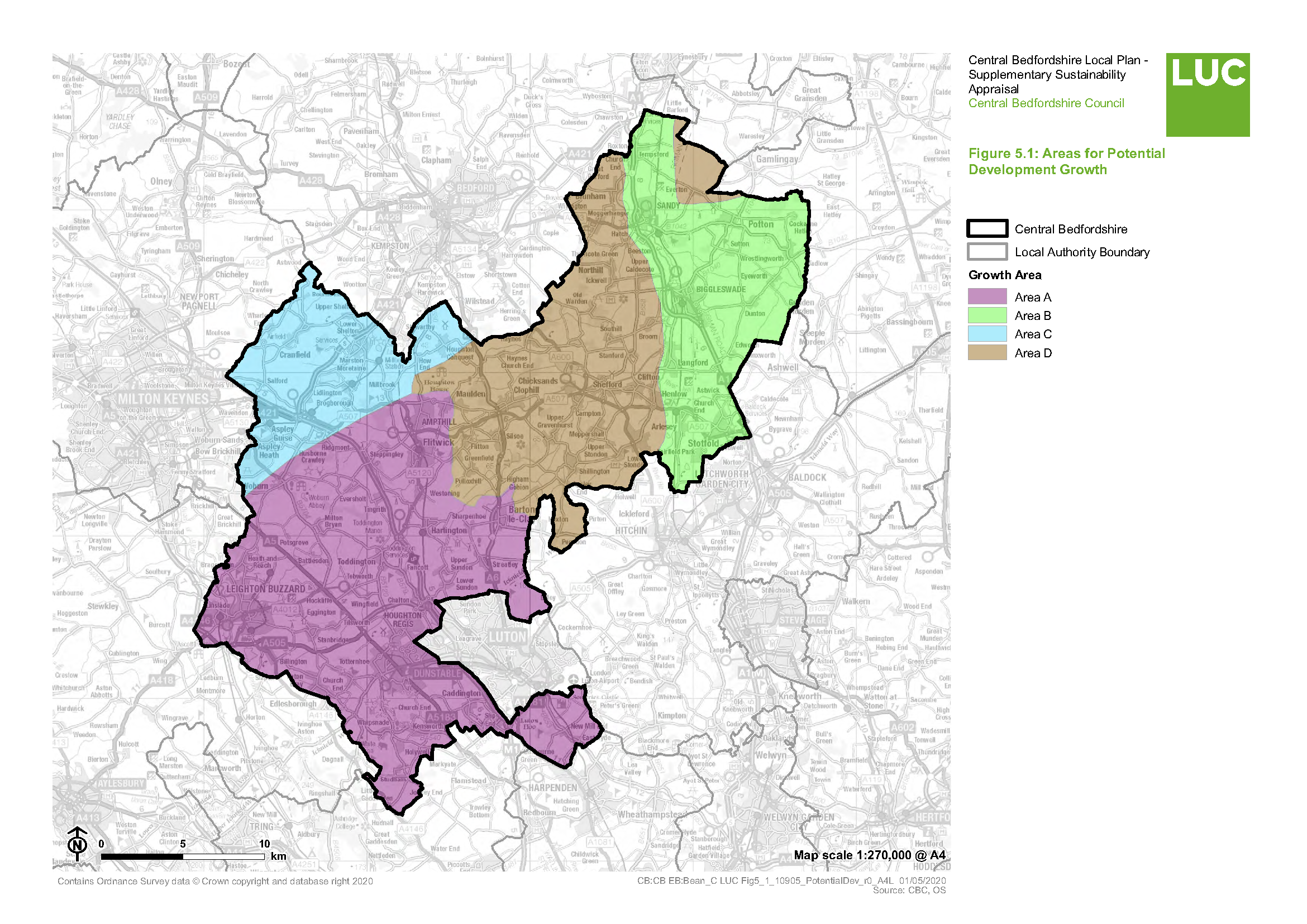
[29] Technically this site falls below the size threshold for a standalone settlement. The site is unique, being a brownfield military site that is earmarked for closure. As such it doesn't fall neatly within any of the categories but is closest to categories 1 and 3.


