Central Bedfordshire Draft Local Plan (July 2017)
3 Consultation
3.1 Council Priorities
3.1.1 The Plan is consistent with the priorities set out in the Council's Five Year Plan 2015.
3.1.2 This Five Year Plan highlights our vision and priorities and sets out these six key priorities for the area.
- enhancing Central Bedfordshire
- great resident services
- improving education and skills
- protecting the vulnerable and improving wellbeing
- creating stronger communities
- a more efficient and responsive council
3.1.3 Whilst the plan aims to achieve all the priorities outlined above, the main priority that the plan aligns to is Enhancing Central Bedfordshire.
This aims to improve Central Bedfordshire as a place to live, by enhancing prosperity with more and better jobs; to improve infrastructure, and to provide the quantity and type of housing needed by our residents while maintaining and enhancing the character of the area. Development will be facilitated by great infrastructure, such as broadband, Wi-Fi and transport. Our Market Towns and villages will thrive and prosper, with improved town centres and facilities[5].
3.1.4 It is considered that the 6 growth themes set out within Sections 4 & 6 are appropriate foundations for the local plan to contribute to achieving the vision and priorities of both the plan and the Council as a whole.
3.2 Shaping Central Bedfordshire Consultation
3.2.1 Rather than starting with a 'blank sheet', the Council undertook public consultation which was structured with the benefit of the known opportunities and constraints for Central Bedfordshire that are identified in Section 2. The purpose of this consultation was to help shape "big picture" options for growth which are set out in this first draft of the Local Plan.
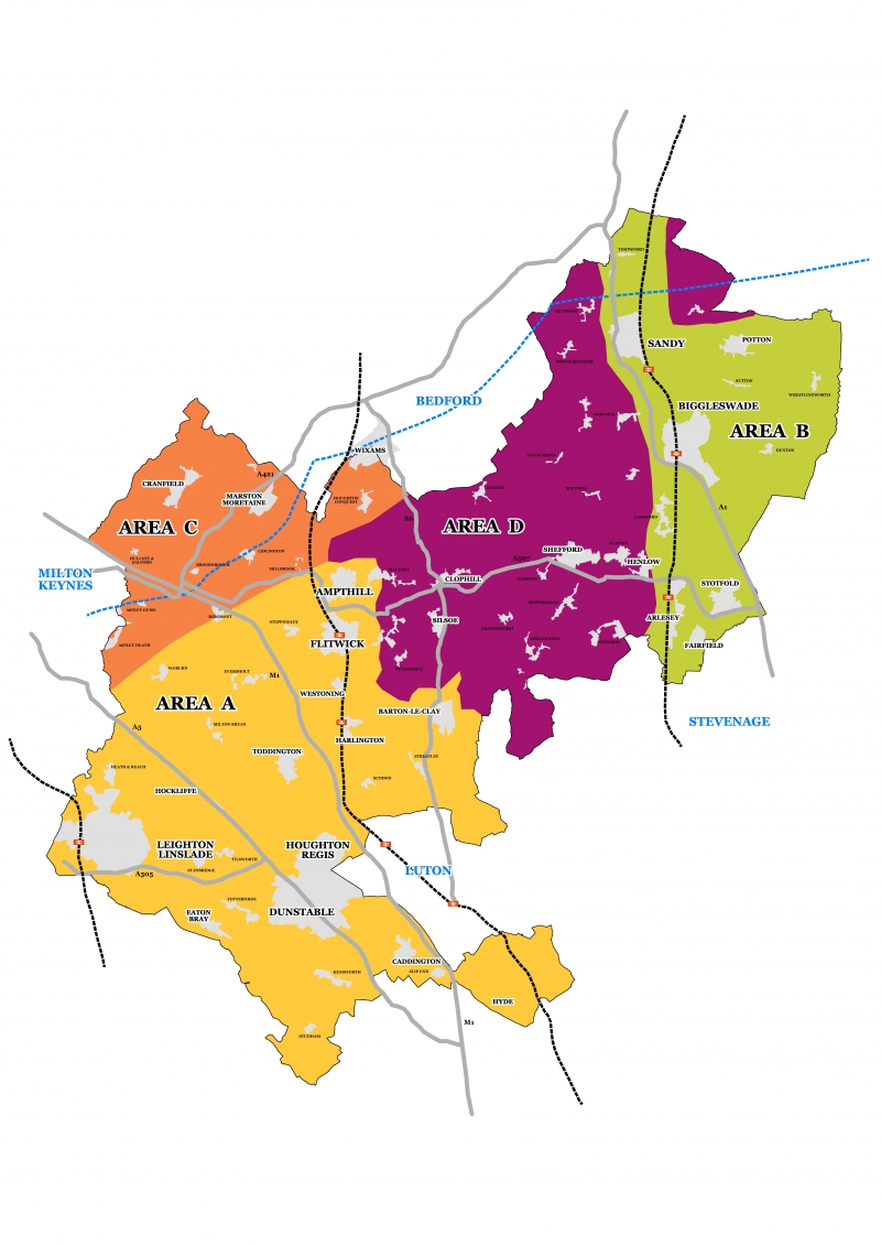
3.2.2 Central Bedfordshire was divided into four areas which reflect the character of our towns, villages and countryside, existing and planned transport corridors, and the Green Belt designation. This was to help us to assess in broad terms growth potential for development of homes, economic opportunities and the scope to invest in local services and amenities. These four areas are shown on the map at Figure 3.1 and are used to group the growth location options in Section 7.
3.2.3 The consultation ran from 13th September to 1st November 2016 and achieved a reasonable level of engagement, with 785 stakeholders providing their views on the proposals. The majority of responses came from residents (679) with others representing a number of businesses, Town and Parish Council's, voluntary and community organisations. The majority of respondents agreed with the characterisation of the four areas as set out within the consultation material. The first draft of the Local Plan therefore evolved following this non-statutory consultation on the high level strategy for growth.
3.2.4 In response to a question which asked for suggestions for broad locations considered suitable for growth, those that responded indicated that growth should be located around existing infrastructure and settlements and suggested the brownfield sites should be used. The approach of looking at existing opportunities like rail stations and looking for the intensification of brownfield sites again has been integrated into the spatial strategy.
3.2.5 Analysis of the consultation responses showed that opinions on how growth should be apportioned broadly demonstrated no clear preference across Areas A, B and D. In Area C however, as an important economic area with advanced research and development at Cranfield Technology Park and Millbrook Proving Ground, a large proportion of respondents agreed that there is potential for medium to strategic scale growth including new settlements and also agreed that there is limited potential for growth at existing settlements. This shows a degree of support and recognition of the growth opportunities and new transport infrastructure in the East West Corridor; and this is reflected in the spatial strategy.
Figure 3.1: Growth Areas
[5] Central Bedfordshire Five Year Plan,
2015


