Central Bedfordshire Draft Local Plan (July 2017)
8 Implementation
8.1 Phasing
8.1.1 The phasing of existing housing commitments has already been determined and is set out within the Housing Trajectory. It is important that new allocations identified by the Local Plan contribute to delivering a continuous supply of housing throughout the plan period. It may also be appropriate for this council to phase the delivery of particular development sites so that construction is not negatively affected by competition in the market, unavailability of resources or deficiencies in infrastructure for example. This could be particularly important for those key strategic sites which are critical to the delivery of the housing strategy. The next draft of the Plan will therefore include a phasing plan to ensure that this is managed effectively. The impact of phasing for strategic scale sites may also be that some sites deliver only a proportion of their total capacity within the plan period.
8.2 Delivery
8.2.1 The draft site assessment technical work demonstrates that there are sufficient sites that meet our initial assessment to ensure that the Local Plan meets the full objectively assessed need of 32,000 dwellings and 30,000 new jobs over the 2015-2035 plan period. This represents an average need of 1,600 dwellings and 1,500 jobs per year.
8.2.2 Local Planning Authorities are also required to 'identify and update annually a supply of specific deliverable sites sufficient to provide five years worth of housing against their requirements'. If this cannot be demonstrated a 'presumption in favour of sustainable development' is applied. It is therefore vital that the Local Plan allocates sufficient deliverable and developable land at range of scales and locations in order to ensure that a five year supply is maintained.
8.2.3 In order to demonstrate a five year supply of housing, significant and demonstrable site specific evidence must be produced. This council regularly contacts housebuilders to determine when their sites will be delivered and this information is added to the Housing Trajectory.
8.3 Housing Boost
8.3.1 While every endeavour will be made within the Local Plan to ensure that there is sufficient housing land to meet the dwelling requirements, the Council recognises that there may be times during the plan period when a five year housing supply cannot be demonstrated. During these times, and where an application is a 'departure' from the Local Plan, the Council requires developers to sign up to a delivery clause in the Section 106 agreement for the scheme that commits them to delivery of a specified number of homes within five years. Whilst it is hoped that this innovative approach is not needed, it provides useful flexibility to even out delivery in the event of a shortfall and ensuring that the planning permission is converted into houses being delivered.
8.3.2 The Council is also considering a policy to be included within the Local Plan which can be activated in circumstances when the supply is low in order to boost housing supply so that the 'presumption in favour of sustainable development' is not applied. This would prevent housing being delivered that bypasses the plan led approach in any location that is considered to be suitable and sustainable, providing certainty to communities.
8.4 Monitoring
8.4.1 Annual housing completions and the supply of housing land will be rigorously monitored on at least an annual basis to determine if delivery requirements are being met and whether the five year supply of housing land is being maintained. The Housing Trajectory and statements on the five year housing land supply will be published within the annual Authority Monitoring Report (AMR) and on the Council's website.
8.4.2 In order to assess the application and effectiveness of all the policies in the Local Plan the Council will produce a monitoring framework. This will list all the policies and set out how they will be monitored. The results of this monitoring will be published each year in the AMR. This will provide valuable evidence of any policy areas where the council may need to take action.
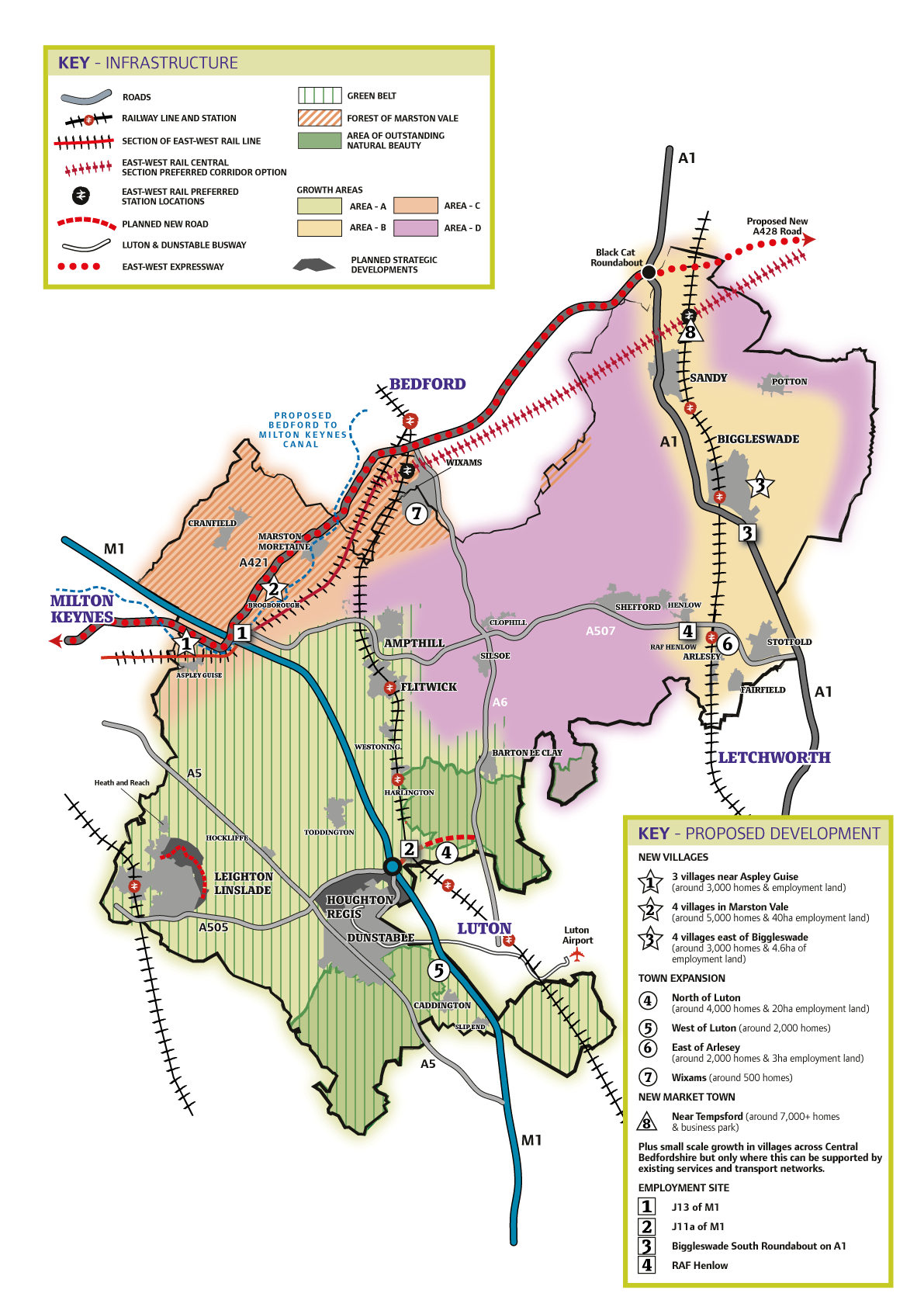
Figure 8.1: The key diagram shows all of the proposed options for strategic growth locations and key employment sites.
Strategic Growth Locations: General requirements for strategic sites
8.4.3 Evidence has shown that the development of large scale new communities (of more than 1500 homes) which are well located for employment and services and have the potential to be well served by sustainable transport will be the most sustainable option for growth alongside development at different scales in proximity to existing settlements. Potential locations for growth are set out at in Policy SP1.
8.4.4 In order to inform the identification of the most appropriate and sustainable locations for growth within Central Bedfordshire, proposals for the delivery of these locations will be expected to demonstrate conformity with the strategic objectives, wider development principles and polices as set out within this plan. They should also meet the following generic requirements for strategic sites as set out below. In the next version of the plan these will be further refined and embedded within the site specific allocation policies.
8.4.5 It is expected that promoters of strategic sites will sign up to a Planning Performance Agreement with the Council. Development proposals bought forward as a result of a PPA at the identified strategic locations should be accompanied by a comprehensive masterplan for the whole site. The masterplan should include :
- An Indicative Masterplan;
Proposals should be based on the creation of a distinctive, well integrated new community which respects its local context, enhances the standards of sustainable design in the locality and relates well to neighbouring settlements.
- A Phasing and Infrastructure plan,
Proposals should follow an organic sequence of development in accordance with a phasing plan previously agreed with the Council, with the timely provision of infrastructure and community facilities to benefit the new community at the earliest possible time; and
Details of how this will be delivered and achieved in a timely manner including detailed viability information.
- A Sustainable Transport Strategy
This should be fully integrated into the overall masterplan and should demonstrate the linkages to existing transport nodes e.g. mainline rail stations and should demonstrate how modal shift will be achieved
8.4.6 Proposals should include the provision of new local community and health hubs. This should include, but is not limited to:
retail facilities to meet locally-generated needs;
small-scale employment uses,
pre-school facilities, and
leisure uses and other social infrastructure, including provision of a Health and Social Care Hub or Healthcare facility, as required, for primary health care to serve the new community.
8.4.7 It is expected that the Community Hubs and Health and Social Care Hubs will be centrally located in close proximity to schools and that it is provided early on in the development programme. Further guidance on these requirements will be provided in the next version of the plan.
8.4.8 Health and Social Care Hubs are a focal point for joining up health, social care and other council services and the delivery of care closer to where people live. The integrated Health and Social Care Hubs will be the main centres for providing proactive and preventative care, out of hospital services and care packages for people who are vulnerable or have complex care needs.
8.4.9 As a minimum these Health and Social Care Hubs are expected to serve as a base for the multi-disciplinary teams (adults and children's) being established as part of the community services redesign programme, including general medical services where possible.
8.4.10 Each Health and Social Care Hub will provide local access to a range of general medical and nursing, therapy, specialist and social care services with supporting information and advice systems.
8.4.11 The Health and Social Care Hubs may also develop a range of additional or enhanced services in line with the needs of the local community. Enhanced services might include:
Extended GP services on a 7 day basis
Enhanced services delivered by and across practices, e.g. minor injury and minor illness services, clinics to support patients with long-term conditions
Face-to-face out of hours consultations
Community pharmacy
Rehabilitation and reablement facilities
Outreach services from local acute hospitals and specialist services, e.g. outpatient appointments and other specialist consultations
Less complex diagnostics
Public Health and prevention services, e.g. smoking cessation, NHS Health Checks, lifestyle hubs
Wellbeing Services and community mental health services
Voluntary and Carer support services.
8.5 Summary of Housing Growth Locations
8.5.1 This long list of growth locations will be refined to form a shortlist of preferred site allocations in the next version of the plan. Not all of these locations will progress to the next stage of the plan once more detailed technical work has been concluded and following the representations received from consultation on this draft of the plan and other engagement with Town and Parish Councils.
8.5.2 The profiles below identify a provisional capacity estimate for each growth location option. These are the number of homes that preliminary technical assessment has shown could be deliverable at a given growth location. These numbers may not however be deliverable in combination with other proposals and within the 20 year lifespan of the Plan. Therefore, Section 7.6 specifies the provisional numbers of homes that are being proposed in this first consultation draft of the Local Plan for each of the growth location options.
|
(Provisional Capacity: 3,500- 4,000 homes; Up to 20 hectares of employment land) |
|
|
Context |
|
|
This Growth Location is located to the north of the built edge of Luton, between the M1 to the west and A6 to the East. The villages of Lower Sundon, Upper Sundon and Streatley lie to the north of the site. The area to the north is also designated as an Area of Outstanding Natural Beauty (the Chilterns AONB). This Growth Location is within the Green Belt, meaning exceptional circumstances would need to be demonstrated to alter Green Belt boundaries to allow development within this Growth Location. The North Luton growth location is a Greenfield site forming part of the landscape character area known as "Houghton Regis – North Luton Rolling Chalk Farmland", but lies beyond the AONB to the west. This chalk dipslope landscape is defined by a gently rolling terrain, dominated by arable crop production, generally with large regular Parliamentary enclosure fields, but with some smaller enclosures adjacent to settlements. There are isolated areas of ancient woodland but the site is largely open in character. Soft landscaping will be essential to mitigating visual impacts within this landscape. Busy transport corridors interrupt the landscape including the M1, A6 and the Midland Mainline Railway. |
|
|
Vision |
|
|
The vision for North of Luton is an extension to Luton that will contribute to the regeneration and enhancement of the surrounding area through provision of a greater range of housing and employment opportunities to meet some of Luton's needs, and through contributions to improve transport links. A new strategic link road between the M1 and A6 will provide relief for surrounding villages and the wider urban area. New local centres with community facilities and public spaces will provide a focal point for community activity and social interaction. New green infrastructure will be provided, linking existing and new green spaces within the Luton urban area through the development and to the countryside to enable greater accessibility and enjoyment of the area's rich historic and natural environment. The development will be designed to respond to and respect its attractive setting and location adjoining, and partly within the Chilterns AONB. |
|
|
Detail |
|
|
Green Belt |
This Growth Location is within the Green Belt; thereby exceptional circumstances would need to be demonstrated to alter Green Belt boundaries to allow development within this Growth Location. |
|
Areas of Outstanding Natural Beauty |
A portion of this Growth Location is located within the Chilterns AONB and within its setting. Great weight is given to conserving the landscape and scenic beauty of the Chilterns AONB, as well as its value for conservation of wildlife and cultural heritage. Development within this Growth Location including built development and new green infrastructure will be required to respond to and respect its attractive setting and location adjoining, and partly within the Chilterns AONB. Major built development should be located beyond the boundaries of the AONB. Potential allocation and future development within this Growth Location must be in conformity with national and local planning policy. |
|
Best and Most Versatile Agricultural Land |
Development within this Growth Location would result in the loss of land in Grades 2 and 3 of the Agricultural Land Classification. Potential allocation and future development within this Growth Location must be in conformity with national policy. |
|
Biodiversity and Blue/Green Infrastructure |
Development would be required to protect endangered species, provide a net gain for biodiversity. The site contains a SSSI, ancient woodland and CWSs. Potential allocation and future development within this Growth Location must be in conformity with national and local policy. Development of this Growth Location provides an opportunity to provide Blue/Green Infrastructure to benefit future occupiers and existing communities. |
|
Flood Risk |
The site falls within Flood Zone 1. Potential allocation and future development within this Growth Location must be in conformity with national policy on flood risk. |
|
Heritage Assets |
This Growth Location contains and/or is within the setting of the following Designated Heritage Assets:
The site contains and/or is within the setting of the following Non Designated Heritage Assets:
The Growth Location has the potential to contain multi-period archaeological remains which would not form an overriding constraint to development but will require investigation, recording and where necessary preservation in situ. Any harm to designated or non designated heritage assets will need to be considered in accordance with national and local planning policy. |
|
Coalescence |
Strategic development within this location could cause coalescence of Luton and Lower Sundon. Appropriate landscape buffers to ensure separation between the urban extension to Luton and existing neighbouring settlements will be required. |
|
Transport |
This Growth Location would benefit from direct connections to the M1 and the A6, providing a new link road between these two strategic roads. This Growth Location is also adjacent to Luton with access to Leagrave Train Station and an opportunity to connect to the Luton and Dunstable Guided Busway. The Government have approved a significant contribution through the South East Midlands Local Enterprise Partnership, to help fund the proposed M1-A6 Link Road. The M1-A6 link road would effectively form a northern bypass for Luton by connecting into the wider strategic road network at the new Junction 11a of the M1 and the new A5-M1 Link. The provision of the M1-A6 link road would relieve existing congestion within surrounding settlements, without which development in this area would cause additional pressure on the road network within Luton and surrounding villages. The delivery of the M1-A6 link road is therefore critical for development in this location and contributions from the development will be required to fully fund the delivery of the road together with a comprehensive scheme for highway and public transport improvements Development in this Growth Location would be required to provide public transport infrastructure within the development and provision of an efficient public transport route through the site that links to the Luton and Dunstable Guided Busway and contribute to improving public transport links to both Leagrave Station and Luton Town Centre. Development in this Growth Location would be required to improve connections (serving both the development and neighbouring settlements) including cycleway connections and footpaths (Rights of Way). |
|
Pollution |
This Growth Location is located near to the following sources of air and noise pollution:
There is potential for land contamination within the site due to historic uses within the landscape. Potential allocation and future development within this Growth Location will require appropriate mitigation in accordance with national and local planning policy. |
|
Utilities |
There are High Voltage Overhead cables and utility services that run through the Growth Location particularly along a north south route. These must be accommodated within the design and layout of the Growth Location to reduce the need for easements within the proposed development. |
|
Infrastructure requirements |
|
|
It is essential that strategic scale development in this location is supported by:
The above local infrastructure and improvements are considered to be essential to support development of this scale but additional items may be identified as a result of more detailed site analysis. |
|
|
(Provisional Capacity: 2,000- 3,600 homes) |
|
|
Context |
|
|
This Growth Location is located to the west of the M1 and to the west built edge of Luton. The village of Caddington lies to the west of the site and the villages, Woodside and Slip End lie to the south. The area to the north is also designated as an Area of Outstanding Natural Beauty (the Chilterns AONB). This Growth Location is within the Green Belt, meaning exceptional circumstances would need to be demonstrated to alter Green Belt boundaries to allow development within this Growth Location. The West Luton growth location is a Greenfield site largely falling within the landscape character area known as Caddington- Slip End Chalk Dipslope but includes areas within the South Dunstable Chalk to the north and north east as well as Slip End Chalk Valley to the south east of this Growth Location. The Chalk Dipslope landscape which forms the large portion of the site is a large scale open landscape with a broad plateau landform undulating to form subtle valleys and providing a sense of elevation. This landscape is predominantly used for arable cultivation, with some horse grazing with fenced paddocks. However the northern part of this landscape is characterised by medium sized deciduous and mixed woodland blocks. Blocks of ancient semi-natural woodland e.g. Badgerdell Wood, Castlecroft Wood, Folly Wood, Stanner's Wood are a key remnant feature and are an important visual element in views. The northern area of the site forms part of the South Dunstable Chalk Escarpment which limits views to the urban edge of Dunstable from within the Chalk Dipslope and provides a natural container to growth and restricts road access to the area. The steep rising topography towards Dunstable and falling topography towards the M1 motorway characterising this Chalk Escarpment on the transition between these landscapes does not feature gradients that lend the northern area of the site to development. Further to the south and east of the site the transition between the Chalk Dipslope and the Slip End Chalk Valley results in a decline in site level, whereby the site falls from an elevated position in relation to the M1 and the landscape becomes dominated by the M1 motorway which is elevated in this landscape character area. The site as a whole features a strong urban fringe character. Views to Luton and the M1 from eastern part of the area, with light pollution, traffic noise, aircraft noise and a major junction at Slip End. |
|
|
Vision |
|
|
The vision for West of Luton is to create a new settlement within the Slip End Chalk Dipslope, appropriately separated from existing settlements of Caddington, Slip End and Woodside as well as the Caddington Woods development to prevent coalescence, whilst avoiding developing in areas of unsuitable topography and in areas considered to be unsuitable for development. The development would provide a mix of homes, business uses and local infrastructure within the growth location to meet identified needs as well as providing a Secondary School that would have the capacity not only to meet the educational needs of the future occupiers of the development but would meet the existing shortfall of secondary school places within the west of Luton. The development would be required to deliver improved pedestrian and cycle connections between the development and surrounding settlements, including Luton as well as a scheme that would provide significant improvements to the local and strategic highway network (the details of which at this stage are unknown), as necessary to make development acceptable. The development would be connected to the Luton and Dunstable Guided Busway improving public transport connections for both the new settlement and surrounding settlements, to decrease the reliance on private motor vehicles. |
|
|
Detail |
|
|
Green Belt |
This Growth Location is within the Green Belt; thereby exceptional circumstances would need to be demonstrated to alter Green Belt boundaries to allow development within this Growth Location. |
|
Areas of Outstanding Natural Beauty |
This Growth Location is located within the setting of the Chilterns AONB. Great weight is given to conserving the landscape and scenic beauty of the Chilterns AONB, as well as its value for conservation of wildlife and cultural heritage. Development within this Growth Location including built development and new green infrastructure will be required to respond to and respect the attractive setting of the AONB. Potential allocation and future development within this Growth Location must be in conformity with national and local planning policy. |
|
Best and Most Versatile Agricultural Land |
Development within this Growth Location would result in the loss of land in Grade 3 of the Agricultural Land Classification. However the split between Grade 3a and 3b is unknown. Potential allocation and future development within this Growth Location must be in conformity with national policy. |
|
Biodiversity and Blue/Green Infrastructure |
Development would be required to protect endangered species, provide a net gain for biodiversity. The site contains areas of ancient woodland and CWSs. Potential allocation and future development within this Growth Location must be in conformity with national and local policy. Development of this Growth Location provides an opportunity to provide Blue/Green Infrastructure to benefit future occupiers and existing communities. |
|
Flood Risk |
The site falls within Flood Zone 1. Potential allocation and future development within this Growth Location must be in conformity with national policy on flood risk. |
|
Heritage Assets |
This site contains and/or is within the setting of the following Designated Heritage Assets:
The site also has the potential to contain multi-period archaeological remains which would not form an overriding constraint to development but will require investigation, recording and where necessary preservation in situ. Any harm to designated or non designated heritage assets will need to be considered in accordance with national and local planning policy. |
|
Coalescence |
Strategic development within this location could cause coalescence of Luton, Caddington, Slip End, Woodside and Caddington Woods. Appropriate landscape buffers to ensure separation between the new settlement and existing neighbouring settlements will be required. |
|
Transport |
This Growth Location is located adjacent to the M1 and Luton beyond, however a new junction to the M1 motorway cannot be achieved due to the required junction separations along that Motorway. This Growth Location does benefit from relatively close proximity to Luton Town Centre and London Luton Airport and is relatively close to the route of the Luton and Dunstable Guided Busway. However the existing highway network serving the site is not designed to cope with the volume of traffic that would result from a strategic scale development in this location. A comprehensive scheme for highway improvements, public transport improvements will be required to mitigate such impacts. Development in this Growth Location would be required to provide public transport infrastructure within the development and provision of an efficient public transport route through the site that links to the Luton and Dunstable Guided Busway and serves both the new settlement and existing neighbouring settlements. Development in this Growth Location would be required to improve connections (serving both the development and neighbouring settlements) including cycleway connections and footpaths (Rights of Way). |
|
Pollution |
This Growth Location is located near to the following sources of air and noise pollution:
There is potential for land contamination within the site due to historic uses within the landscape. Potential allocation and future development within this Growth Location will require appropriate mitigation in accordance with national and local planning policy. |
|
Topography |
The gradients of the South Dunstable Chalk landscape to the far north of this Growth Location do not lend that area of the Growth Location readily to development and the topography forms a barrier to the creation of new and/or improved accesses/connections to the north (Hatters Way and Busway) and northeast (to Luton). Development in the latter area would require significant engineering interventions to achieve appropriate gradients for surface water drainage, vehicles, pedestrians, disabled users and cyclists as well as to form new or improved accesses/ connections. Such interventions may cause significant environmental impacts as a result and could be financially costly. |
|
Utilities |
There are High Voltage Overhead cables and utility services that run through the Growth Location particularly along a north south route. These must be accommodated within the design and layout of the Growth Location to reduce the need for easements within the proposed development. It may be require the relocation of overhead lines underground. |
|
Infrastructure requirements |
|
|
It is essential that strategic scale development in this location is supported by:
The above local infrastructure and improvements are considered to be essential to support development of this scale but additional items may be identified as a result of more detailed site analysis. |
|
|
(Provisional Capacity: 2000 homes) |
|
|
Context |
|
|
The Growth Location is located between Arlesey in the east and Fairfield in the west. The site, approximately 296 ha in size, adjoins Arlesey Cross (Policy MA8 of the Central Bedfordshire (North) Site Allocations Development Plan Document) in the north and extends south of Arlesey beyond the Blue Lagoon. The site adjoins the A507 in the west and is located approximately 2.6km from Arlesey Train Station to the north west and Letchworth Train Station is located approximately 2,5km from the southern portion of the site. Arlesey Cross, Policy MA8 area, is located to the north of the East of Arlesey Growth Location. A Master Plan for this site was approved by Central Bedfordshire Council for development management purposes in March 2014. This document establishes an indicative framework for Policy MA8 land. Although this Master Plan does not cover the area comprising the East of Arlesey Growth Location it will be essential for any future master planning of this Growth Location to take account of the principles and layout of Arlesey Cross and the detail of approved planning permissions associated with that allocated site. This will be essential for ensuring that the future growth of Arlesey is sustainable and integrated. |
|
|
Vision |
|
|
It is envisaged that strategic scale development at this site should appear as an extension to Arlesey whilst retaining an appropriate separation between Arlesey and Fairfield. Development in this Growth Location as an extension to Arlesey could provide significant benefits in relationto the provision of a significant number of homes including older person's accommodation, a relief road and a country park to benefit both new and existing residents, whilst benefiting from relatively close proximity to the A1, the A507 and the East Coast Mainline Rail. |
|
|
Detail |
|
|
Biodiversity and Blue/Green Infrastructure |
Development would be required to protect endangered species and, provide a net gain for biodiversity. The site contains a SSSI and CWSs. Potential allocation and future development within this Growth Location must be in conformity with national and local policy. Development of this Growth Location provides an opportunity to provide significant Blue/Green Infrastructure including a country park between Arlesey and Fairfield to benefit future occupiers and existing communities. The Arlesey Parish Green Infrastructure Plan identifies a number of community aspirations, which should be carefully considered in the master planning for any development in this Growth Location including the provision of allotments and an extension to the existing recreation ground. This Growth Location has the potential to deliver a net Green Infrastructure benefit with additional enhancements on the western edge of the site. |
|
Best and Most Versatile Agricultural Land |
Development within this Growth Location would result in the loss of land in Grades 2 and 3 of the Agricultural Land Classification. Potential allocation and future development within this Growth Location must be in conformity with national policy. |
|
Flood Risk |
The site falls within Flood Zone 1. Potential allocation and future development within this Growth Location must be in conformity with national policy on flood risk. |
|
Heritage Assets |
This site contains and/or is within the setting of the following Designated Heritage Assets:
The site also has the potential to contain multi-period archaeological remains which would not form an overriding constraint to development but will require investigation, recording and where necessary preservation in situ. Any harm to designated or non designated heritage assets will need to be considered in accordance with national and local planning policy. |
|
Coalescence |
Strategic development within this location could cause coalescence of Arlesey, Fairfield and Stotfold. Appropriate physical separation and visual buffering through extensive soft landscaping will be required to ensure separation between the envisaged extension to Arlesey and neighbouring settlements, as part of a new blue/green infrastructure. |
|
Transport and Connectivity |
The Growth Location will benefit from proximity to the strategic highway network, notably the A507 and A1, and East Coast Mainline Rail. To access the A507 and A1, a relief road through the Growth Location will be required as the primary access which will connect the area from south of Hitchin Road to the A507/High Street Link Road in the north being proposed as part of Arlesey Cross. This will allow for access directly onto the A507 and should help ease congestion along the High Street in Arlesey. Additional links from the Growth Location through to the existing High Street will be required to facilitate permeability and integration connectivity between the new and existing development in Arlesey. Development in the Growth Location will be required to maximise connectivity between new and existing settlements as well as connections to Arlesey Train Station through vehicular, public transport, cycleway connections and footpaths as well as through green infrastructure. Connectivity and integration between East of Arlesey Growth Location and Arlesey Cross is essential in ensuring the sustainability of Arlesey as a town as a whole. This should be achieved through the compatibility of the proposed layouts of both locations and connections between the two areas as well as connectivity with the existing built form in Arlesey. |
|
Utilities |
There are a number of utilities and pipeline corridors that run through the Growth Location particularly along a north south route. These must be accommodated within the design and layout of the Growth Location to reduce the need for easements within the proposed development. |
|
Infrastructure requirements |
|
|
It is essential that strategic scale development in this location is supported by:
The above local infrastructure and improvements are considered to be essential to support development of this scale but additional items may be identified as a result of more detailed site analysis. |
|
|
(Provisional Capacity: 5000 homes; 40ha employment R&D, office, distribution, manufacturing, service and tourism) |
|
|
Context |
|
|
The Growth Location is located to the west of Marston Moretaine, to the north of Lidlington and to the east of Brogborough. The site is bound to the north by the new A421 and to the south by the Marston Vale railway line which is to form part of the East-West Rail route. Ridgmont Train Station has been confirmed as an East-West Rail Interchange and this is relatively close to this Growth Location. The Marston Vale Growth Location is a greenfield site within the North Marston Clay Vale which is a large scale, open vale, located between the elevated landscapes of the Wooded Greensand Ridge on its southern boundary and the Cranfield to Stagsden Clay Farmland to the west that provides a sense of containment. The landscape has a mix of agriculture and is fragmented by industrial activity including brick works, open cast clay pits, landfill, distribution centres and industrial estates. The legacy of clay extraction for brickmaking has resulted in a disturbed landscape with past and ongoing restoration. Flooded clay pits form a series of lakes throughout the vale such as Brogborough and Lidlington lakes within the Growth Location which have created recreational value and ecological interest. |
|
|
Vision |
|
|
It is envisaged that strategic scale development in this Growth location could include, a business park and a series of four new villages separated and screened from neighbouring settlements by appropriate landscape buffers. Strategic scale development in this Growth Location could provide a significant number of homes and jobs to meet identified needs and could provide a significant section of the Bedford and Milton Keynes Waterway Park and waterway. Development would seek to maximise the environmental, leisure and community benefits from both the waterway and the existing lakes providing habitat creation, waterfront community hubs and leisure opportunities. Development within this location could also benefit from a heat network associated with any future Energy Recovery Facility at Rookery Pit South. |
|
|
Detail |
|
|
Biodiversity and Blue/Green Infrastructure |
The site contains two CWSs and a Great Crested Newt recolonisation area. The site is located within the Forest of Marston Vale, contains a significant section of the planned route for the Bedford and Milton Keynes Waterway Park and a portion of the site is also located within the Green Sand Ridge Nature Improvement Area. Development would be required to protect endangered species, provide a net gain for biodiversity, contribute to the Forest of Marston Vale and would be expected to deliver the section of the Waterway Park as well as delivering that section of the waterway. Development of this site provides the following site specific opportunities:
|
|
Flood Risk |
The majority of the site falls within Flood Zone 1, however there area portions of this site are within Flood Zone 2 and 3. Potential allocation and future development within this Growth Location must be in conformity with national policy on flood risk. |
|
Heritage Assets |
This Growth Location contains and/or is within the setting of the following Designated Heritage Assets:
The site also has the potential to contain multi-period archaeological remains which would not form an overriding constraint to development but will require investigation, recording and where necessary preservation in situ. Any harm to designated or non designated heritage assets will need to be considered in accordance with national and local planning policy. |
|
Coalescence |
Strategic development within this location could cause coalescence of Lidlington and Marston Moretaine. Appropriate landscape buffers to ensure separation between new villages and existing settlements will be required. |
|
Transport |
Development within this site will benefit from proximity to the Millbrook and Lidlington Train Station on a Branch Line service in addition to relatively close proximity to the new East-West Rail Interchange planned to be at Ridgmont. This site is also adjacent to the A421 with an existing access at Marston Moretaine and Junction 13 of the M1 which can be accessed via Brogborough. Development would likely cause additional pressure at the M1 Junction 13, increased vehicular movements within Marston Moretaine as traffic heads towards the A421 and would increase vehicular movements through neighbouring villages towards the A507. A comprehensive scheme for highway improvements, public transport improvements will be required. Development will be required to improve connectivity between new and existing settlements as well as connectivity to Ridgmont Train Station including public transport connections (serving both the development and neighbouring settlements), cycleway connections and footpaths (including Rights of Way). |
|
Pollution |
This Growth Location is located near to the following sources of air and noise pollution:
There is potential for land contamination within the site due to historic uses within the landscape. Potential allocation and future development within this Growth Location will require appropriate mitigation in accordance with national and local planning policy. |
|
Energy |
There is an opportunity to connect development within this Growth Location to the heat network associated with the planned Energy Recovery Facility at Rookery Pit South (Combined Heat and Power Station). |
|
Utilities |
There are High Voltage Overhead cables and utility services that run through the Growth Location particularly along a north south route. These must be accommodated within the design and layout of the Growth Location to reduce the need for easements within the proposed development. |
|
Infrastructure requirements |
|
|
It is essential that strategic scale development in this location is supported by:
The above local infrastructure and improvements are considered to be essential to support development of this scale but additional items may be identified as a result of more detailed site analysis. |
|
|
(Provisional Capacity: 3,000-3,500 homes) |
|
|
Context |
|
|
The Growth Location is situated in the parish of Aspley Guise, to the north of the main built-up area of Aspley Guise village, the north east of Woburn Sands and to the south west of Brogborough. The site's northern boundary is defined by the M1, with junction 13 to the east, and the A421 leading into Milton Keynes, the southern boundary of the Growth Location abuts the Marston Vale railway line which forms part of the East-West rail route. This Growth Location benefits from the proximity to Milton Keynes, the A421, M1, Aspley Train Station (branch line) and the planned East West Rail interchange at Ridgmont Train Station (although separated from this Growth Location by the M1). This Growth Location consists of arable farmland predominantly lying within the Aspley Clay Vale, a significant open featured vale that stretches northwards, enveloping Hulcote and Salford. The site is contained by distinctive landscapes and is situated to the north of the elevated landscape that resembles the Greensand Ridge that covers both Husborne Crawley and Aspley Guise. It is also situated to the south of the Cranfield to Stagsden Farmland. |
|
|
Vision |
|
|
It is envisaged that strategic scale development in this Growth location could include, a series of linked village separated and screened from neighbouring settlements by appropriate landscape buffers, which would benefit from direct access to the A421 and benefiting from good access to Milton Keynes, the M1, East-West Rail and the planned Oxford to Cambridge Express Way. Strategic scale development in this Growth Location could provide a significant number of homes and jobs to meet identified needs and could provide a significant section of the Bedford and Milton Keynes Waterway Park and waterway. Development would seek to maximise the environmental, leisure and community benefits from both the waterway providing habitat creation and leisure opportunities. The proposed Oxford to Cambridge Expressway has a narrow corridor to connect to the A421 which would likely cross through this Growth Location, however the exact alignment of the expressway is yet to be determined. Due to the location of this site and the relatively narrow corridor to make this strategically important connection, it is considered that development within this Growth Location should not proceed until a route has been identified and safeguarded, which may potentially affect the deliverability of development in this Growth Location within the plan period. |
|
|
Detail |
|
|
Biodiversity and Blue/Green Infrastructure |
The site contains a significant section of the planned route for the Bedford and Milton Keynes Waterway Park and a portion of the site is also located within the Green Sand Ridge Nature Improvement Area. Development would be required to protect endangered species, provide a net gain for biodiversity and would be required to deliver the section of the Waterway Park as well as delivering that section of the waterway. Development of this site provides the following site specific opportunities:
|
|
Best and Most Versatile Agricultural Land |
Development within this Growth Location would result in the loss of land in Grade 3 of the Agricultural Land Classification. However the split between Grade 3a and 3b is unknown. Potential allocation and future development within this Growth Location must be in conformity with national policy. |
|
Flood Risk |
This Growth Location largely falls within Flood Zone 1; however there are portions of the Growth Location within Flood Zones 2 and 3. Potential allocation with future development within this Growth Location must be in conformity with national policy on flood risk. |
|
Heritage Assets |
There are a significant number of listed buildings within Aspley Guise and Husborne Crawley. Impacts on the setting of these will need to be considered as there are a number of listed buildings south of Aspley Guise Railway Station. The site contains and/or is within the setting of the following Designated Heritage Assets:
The site also has the potential to contain multi-period archaeological remains which would not form an overriding constrain to development but will require investigation, recording and where necessary preservation in situ. Any harm to designated or non-designated heritage assets will need to be considered in accordance with national and local planning policy. |
|
Coalescence |
Strategic development within this location could cause coalescence between the new settlement and Aspley Guise, contributing to future coalescence of Milton Keynes and Aspley Guise. Appropriate landscape buffers to ensure separation between new village and existing settlements will be required. |
|
Transport |
The site is adjacent to and would be directly accessed from the A421 whereby there are concerns relating to traffic and queuing implications from the development as well as implications for the M1 Junction 13. Development will likely have traffic implications for the surrounding settlements and minor road networks, including the level crossings in Woburn Sands and Aspley Guise. With the introduction of East-West Rail, queuing times at level crossings will likely increase, whereby a scheme may be necessary to mitigate such impacts. The site currently benefits from its proximity to the Marston Railway Line and the site will experience further benefits with the introduction of East-West Rail which is planned to have an interchange at Ridgmont. The proposed Oxford to Cambridge Expressway has a narrow corridor to connect to the A421 which would likely cross through this Growth Location, however the exact alignment of the expressway is yet to be determined. Due to the location of this site and the relatively narrow corridor to make this strategically important connection, it is considered that development within this Growth Location should not proceed until a route has been identified and safeguarded, which may potentially affect the deliverability of development in this Growth Location within the plan period. A comprehensive scheme for highway improvements will be required. Development will be required to improve connectivity between the development and existing settlements as well as connectivity to Milton Keynes and Ridgmont Train Station including public transport connections (serving both the development and neighbouring settlements), cycleway connections and footpaths (including Rights of Way). |
|
Pollution |
This Growth Location is located near to the following sources of air and noise pollution:
There is potential for land contamination within the site due to historic uses within the landscape. Potential allocation and future development within this Growth Location will require appropriate mitigation in accordance with national and local planning policy. |
|
Energy |
There is an opportunity to connect development within this Growth Location to the heat network associated with the planned Energy Recovery Facility at Rookery Pit South (Combined Heat and Power Station). |
|
Infrastructure requirements |
|
|
It is essential that strategic scale development in this location is supported by:
The above local infrastructure and improvements are considered to be essential to support development of this scale but additional items may be identified as a result of more detailed site analysis. |
|
|
(Provisional Capacity: 500 homes and a Country Park) |
|
|
Context |
|
|
The Growth Location is located north of Houghton Conquest and south of the Wixams Main Settlement, a new settlement that lies within both Bedford Borough Council and Central Bedfordshire Council. The Growth Location is bounded by the B530/Ampthill Road in the west and Bedford Road in the south. The Growth Location does not extend as far eastwards as the A6. Immediately south of the Wixams Main Settlement is land currently allocated by Policy MA3 of the Central Bedfordshire (North): Site Allocations Development Plan Document for mixed-use development for up to 1,000 new homes. This allocation has not been built out but must be delivered before the proposed growth location. Land to the South of Wixams Growth Location lies immediately south of Policy MA3 allocation. The Growth Location was formally known as Draft Policy 63 Allocation from the now withdrawn Central Bedfordshire Development Strategy. A master plan was approved by Central Bedfordshire Council for development management purposes in April 2015. The Wixam Park Master Plan establishes an Indicative Framework Plan for Wixam Park, an area comprising Policy MA3 land together with the land to the south known now as Land South of Wixams Growth Location. Policy MA3 and the Land South of Wixams Growth Location are two separate policy areas but have been masterplanned together within the Wixam Park Master Plan Document. |
|
|
Vision |
|
|
Development in this Growth Location provides an extension to the Wixams Main Settlement and Policy MA3 land. The Growth Location could provide significant benefits with the provision of a significant number of homes and a countryside park whilst benefiting from relatively close proximity to the planned development at Wixams Main Settlement and associated facilities and services, a proposed Wixams Rail Station, East-West Rail, the A421 and A6. |
|
|
Detail |
|
|
Transport and Connectivity |
The Growth Location would extend Wixams Main Settlement to the south through Policy MA3 land, therefore it is essential that the Growth Location and Policy MA3 land are comprehensively planned to ensure they are connected and integrated into a sustainable settlement for Wixams as a whole. This has been partly achieved through the adoption of the Wixam Park Master Plan Document, which outlines the land uses and connections between the two areas and with Wixam Main Settlement to achieve the interconnectedness and integration of development in this area. Although the site benefits from close proximity to the strategic highway network, namely the A6, access to the Growth Location will be via the B530. Access connections should also be between the Growth Location and Policy MA3 land and Wixams Main Settlement to facilitate convenient access between the development areas and to promote more sustainable forms of travel. The Growth Location's immediate location with the Wixams Main Settlement, particularly the proximity to the proposed new railway station also provides a significant opportunity for the Growth Location in terms of strategic sustainable connections. Development within this Growth Location, together with Policy MA3 land, would be required to maximise connectivity between the separate developments of Wixams Main Settlement, Policy MA3 land and the Growth Location by ensuring the proposed layouts and masterplans promotes connectivity by including vehicular, public transport, cycleway connections and footpaths. |
|
Coalescence |
Strategic development within this location could cause coalescence of Houghton Conquest and an extended Wixams. Appropriate landscape buffers to ensure separation between Houghton Conquest and land south of Wixams will be required. Indicative masterplans for the site, as well as the adopted Masterplan, indicate the inclusion of a countryside park along the southern boundary with Houghton Conquest. This will provide a separation between Houghton Conquest and the new development by providing a functional open space for the residents of Houghton Conquest and the new community. |
|
Biodiversity and Blue/Green Infrastructure |
In addition to preventing coalescence, the countryside park will be linked with green infrastructure provision in the Growth Location. This will present an opportunity to deliver new strategic areas of open space. As the Growth Location is located in the Marston Vale, tree cover throughout any new development should contribute to the Forest of Marston Vale |
|
Flood Risk |
The site falls within Flood Zone 1. Potential allocation and future development within this Growth Location must be in conformity with national policy on flood risk. |
|
Heritage Assets |
The site lies within a landscape that is known to contain multi-period archaeological remains, therefore it has archaeological potential. This does not prevent development providing that an appropriate mitigation strategy is implemented. Archaeological field evaluations must be undertaken and a contingency for archaeological works must be included in any proposal to prevent issues with viability. |
|
Energy |
There is an opportunity to connect development within this Growth Location to the heat network associated with the planned Energy Recovery Facility at Rookery Pit South (Combined Heat and Power Station). |
|
Infrastructure requirements |
|
|
It is essential that strategic scale development in this location is supported by:
The above local infrastructure and improvements are considered to be essential to support development south of Wixams Main Settlement but additional items may be identified as a result of more detailed site analysis. |
|


