Housing Technical Paper [EXAM 113]
3. Response to EXAM 69
3.1 Key Points Raised in Relation to Housing Allocations
3.1.1 The Inspectors letter (EXAM 69) summarised the main issues that arose during the Examination hearing sessions, and that the Inspectors remained concerned with.
3.1.2 In terms of the housing allocations, as well as identifying issues with the Sustainability Appraisal (SA), the letter refers to site-specific issues for the strategic allocations and a small number of small and medium allocations proposed within the Local Plan. The following sites are discussed:
- SA1 Land North of Luton
- SA2 Marston Vale New Villages
- SA3 East of Arlesey
- SA4 East of Biggleswade
- HAS03 (Land off Meadow View) Aspley Guise
- HAS04 (Land at Luton Road) Barton le Clay
- HAS09 (Land at Chapel Farm) Chalton
- HAS20 (Land West of Midland Mainline Railway) Harlington
- HAS24 (Land South West of the A5) Hockliffe
- HAS25 (Land at Leighton Road) Hockliffe
- HAS26 (A5 Watling Street) Hockliffe
3.1.3 The Council's response to these site specific issues and the approach the Council has taken to addressing them is set out below.
3.2 Sustainability Appraisal – Supplementary Report (May 2020)
3.2.1 A significant point made by the Inspectors in EXAM 69 is in relation to the Sustainability Appraisal (SA). In terms of the residential site allocations, concerns were raised around the testing of alternative options and whether all options had been appropriately considered.
3.2.2 In response to this, the Council commissioned LUC to undertake an independent review of the SA (incorporating Strategic Environmental Assessment (SEA)) to address the Inspectors points by revisiting and reappraising the reasonable alternative options for the Spatial Strategy and strategic housing and employment site options, where necessary.
3.2.3 What is important to note is that, whilst the Regulation 18 and 19 SA (ED C30 and ED C31) did not necessarily present the consideration of alternative options in the most appropriate or clear way, a comprehensive consideration of options was undertaken both as part of this process and by Officers when selecting the sites to be allocated within the Plan. The issue was around how this was demonstrated within the SA reports. As such Officers were, and remain, confident that the Strategy set out in the Local Plan is the correct one.
3.2.4 Notwithstanding this, there were some particular sites, as highlighted within EXAM 69, where alternative capacities have been discussed and put forward and should therefore be considered within the SA. The review of the SA was undertaken by independent consultants and the Council committed to making changes to the Strategy, if required, when considering the outcome of this work.
3.2.5 A Supplementary SA Report has been produced (EXAM 115-115B) which should be read alongside this Technical Paper. The results of this work have been incorporated into the following site-specific sections of this Technical Paper, where appropriate.
3.3 SA1: North of Luton
Background
3.3.1 The Council has committed to delivering 7,350 of Luton Borough Council's (LBC) unmet housing need within its area, which EXAM 69 acknowledges is a positive and commendable strategy, bearing in mind LBC's tightly drawn boundary, bounded on all sides by Green Belt.
3.3.2 Options for growth around Luton have been assessed through plan making over a number of years, previously through the Joint Core Strategy (2011) prepared in collaboration with Luton Borough Council, and the subsequent Development Strategy (2015), a development plan prepared solely by Central Bedfordshire Council. Although neither plan proceeded to Adoption, North of Luton was included as a draft allocation for strategic scale development in both plans having been assessed and identified as a sustainable location for development.
3.3.3 In preparing this Local Plan, the North of Luton site was submitted through the Call for Sites in 2016 (site reference NLP426) for a mixed-use urban extension of up to 4000 dwellings and commercial development. The Council considered a number of alternative options to deliver growth to meet Central Bedfordshire's needs, and Luton's unmet housing needs. Following a robust site assessment process, and after due consideration of the technical evidence base, North of Luton was selected for allocation for 4000 homes, up to 20ha of employment and associated facilities in the submitted Local Plan. The allocation also required the delivery of a new strategic Link Road between the M1 and A6.
3.3.4 The Council and the site promoter agreed a Site Delivery Statement (May 2019, appended to the Council's Matter 6 Statement). This included an agreed build-out trajectory, key infrastructure milestones and an indicative programme for the delivery of the allocation.
3.3.5 At Regulation 19, Natural England and Historic England raised concerns about the impact of the full allocation on the Chilterns Area of Outstanding Natural Beauty (AONB) and heritage assets within and in close proximity to the site. Accordingly, a LVIA (EXAM 7I) and HIA (EXAM 7N) were prepared for the site following the submission of the Local Plan. In response to their conclusions, the Council proposed a reduction of the developable area to exclude the area to the east of the site referred to as the 'eastern bowl'. The eastern bowl includes land to the north and south of the M1-A6 Link Road, adjacent to the A6 and a resulting illustrative land use plan is included in the Examination Library at EXAM 7F. This position was agreed in Statements of Common Ground with Natural England (EXAM 7E) and Historic England (EXAM 7J) and presented to the Inspectors in the Council's Matter 6 Statement. The reduction in the developable area resulted in a lower quantum of growth being deliverable on the site – approximately 3,100 homes, 7ha of B use employment and a proportionate reduction of associated community facilities. This reduction in capacity did not affect the sites contribution to the overall housing numbers within the Plan Period. The Housing Trajectory identified that 3,100 homes would be delivered within the Plan Period with the remaining homes being delivered beyond 2035. This reduced capacity was assessed via an addendum to the SA (EXAM 7T), which considered the LVIA and HIA for North of Luton and removed the uncertainties relating to impacts on the AONB and heritage assets and their settings. The 3,100 home option was found to be more positive as its potential impacts on landscape and the historic environment were reduced.
3.3.6 In response to this, the site promoters presented a further alternative option in their Matter 6 Statement. This option excluded land to the north east of the site, to the north of the M1-A6 Link Road, from the red line boundary but proposed that some sensitively designed development could be accommodated in the southern part of the eastern bowl – the south eastern parcel between Keech Hospice and the A6. This option could deliver approximately 3,600 dwellings, 7ha of employment and associated community facilities including primary and secondary school provision, health facilities and open space. It could also provide a higher proportion of affordable housing to meet Luton's needs. This option had not been previously considered by the Council.
3.3.7 The Supplementary SA Report (EXAM 115) now considers all of these potential options, to identify the most appropriate Strategy, the conclusions of which are set out below.
Response to EXAM 69
3.3.8 EXAM 69 raises two key issues for North of Luton; the status and alignment of the M1-A6 Link Road (and how it is dealt with within Policy SA1), and the assessment of reasonable alternative options within the SA. These are dealt with in turn below.
M1-A6 Link Road
3.3.9 Paragraphs 17 to 22 of EXAM 69 raise concerns around the alignment of the Link Road and the evidence justifying it, particularly in view of its route through the AONB.
3.3.10 In 2015, the Council prepared a Framework Plan in collaboration with the site promoters of North of Luton and Sundon Rail Freight Interchange (RFI). The purpose of this document was to demonstrate how the site allocations being proposed through the Development Strategy at that time could be delivered. In preparing the masterplan, consideration was given to the previous assessments of route options for a link road to the north of Luton. These options studies have since been summarised in supporting documents to the M1-A6 Link Road planning application and relevant sections were provided to the Inspectors for reference following the Examination hearings (EXAM 43-49, EXAM 50-54 and EXAM 55). The comprehensive masterplanning of this site through the Framework Plan process identified that a northern alignment was the most appropriate option, the justifications for which were set out in paragraphs 4.6.1 to 4.6.4 of the Council's Matter 6 Statement. Given the previous testing of alignment options and the demonstration through the Framework Plan that a northern alignment was the most sustainable option, the Council did not consider it necessary to test alternative route alignment options in the preparation of this Local Plan.
3.3.11 A planning application for the Link Road (CB/19/00887/FULL) was registered on 19 March 2019 and was progressing throughout the duration of the Examination, with the Council providing updates to the Inspectors and participants. Since the close of the Examination hearings the Council has granted consent for the M1-A6 Link Road (9 January 2020). As such, it is now a commitment, which constitutes a material change since the Local Plan was submitted. This has been taken into account within the Supplementary SA (EXAM 115), which, in line with SA guidance, deals with the Link Road as an existing commitment within the baseline. Further information on the M1-A6 Link Road can be found within the Transport Technical Paper (EXAM 114).
3.3.12 Policy SA1 requires modifications to reflect this material change in circumstance, which are detailed in paragraph 3.3.53 below.
Assessment of Reasonable Alternatives
3.3.13 Paragraph 9 of EXAM 69 states that at the Examination hearing sessions the Council suggested that the North of Luton allocation is derived from the Framework Plan. The Council did not intend to suggest that this document justified the allocation. The Framework Plan was supported by a substantial evidence base and was prepared to support the allocation policy in the, now withdrawn, Development Strategy. This document was prepared in collaboration between the Council and the site promoters of both North of Luton and Sundon RFI. It was subject to extensive public consultation and was adopted as technical guidance for development management purposes in 2015 to guide future development of the site. It did not form part of the statutory development plan nor was it formally prepared as a Supplementary Planning Document (SPD). The Council chose to refer to this document simply to demonstrate how a 4,000 dwelling allocation and the Link Road may be brought forward. Policy SA1 requires the preparation of a Development Brief to set out the key principles for the development and ensure it is in accordance with the Local Plan and national policy and guidance. This would supersede the endorsed Framework Plan.
3.3.14 The selection of sites for inclusion in the submitted Local Plan has been informed by a robust assessment process, taking into account an extensive evidence base, which will be discussed in more detail below. Through this process, North of Luton was identified as the most sustainable option for strategic scale growth around the Luton area, to meet Luton Borough Council's unmet housing needs.
3.3.15 Paragraphs 4 to 9 and 16 to 22 of EXAM 69 refer to the need for the SA to thoroughly consider the alternatives available in Area A and particularly around Luton. The growth scenarios tested within the SA are criticised for being limited and excluding some alternative options. Whilst Officers are content that options were fully considered throughout the plan making process, it is acknowledged that the Regulation 18 and 19 SA (ED C30 and ED C31) does not clearly reflect that consideration. Furthermore, the 3,100 and 3,600 home options for North of Luton were not identified until after the Submission of the Plan.
3.3.16 The Supplementary SA Report (EXAM 115) reviews the existing SA and assesses all realistic alternative options for growth in response to the issues raised in EXAM 69.
Where the Need Should Be Met
3.3.17 The SA has appraised options for the distribution of growth across Central Bedfordshire and within Areas A to D.
3.3.18 The Supplementary SA Report (EXAM 115 and 115B, paragraphs 2.13 to 2.17, Chapter 4 and Appendix D) has refined the growth distribution typologies set out in the Regulation 19 SA to be more reflective of the schemes being considered as alternative options, and looks at 6 growth distribution options:
- Option 1: New settlement (village scale) – 1,500-5,000 new homes
- Option 2: New settlement (town scale) – more than 5,000 new homes
- Option 3: Village extensions – especially those with services and facilities
- Option 4: Growth around strategic roads
- Option 5: Growth around sustainable transport hubs
- Option 6: Urban extensions assumed to be 1,500-4,000
3.3.19 In terms of delivering housing (SA Objective 1), the SA concludes that five of the six distribution options have significant positive impacts, with Option 3 (village extensions) having a minor positive effect, due to the smaller scale of new development that could be achieved.
3.3.20 Overall, the Supplementary SA identified that Option 2 (larger new settlements), Option 5 (growth around sustainable transport hubs) and Option 6 (urban extensions) are expected to have the most significant positive effects. The poorest performing options in the SA were Option 3 (village extensions) and Option 4 (growth around strategic roads), with Option 1 (village scale new settlements) falling in the middle of these two groups. Paragraph 5.2.1 of the SA concludes that CBC should be looking largely towards distribution types 2, 5 and 6, and then 1, when considering alternative options for the greatest contribution to meeting development needs, although it recognises that villages may be able to make some provision. The larger scale of development that would result from Options 2 and 6 means there should be good opportunities for the provision of services and facilities, employment opportunities, green infrastructure and sustainable transport infrastructure. New developments should therefore be more self-contained and more easily able to establish their own character.
3.3.21 These options are not intended to be alternatives, but rather will guide the consideration of sites when assessing the alternative options.
3.3.22 Areas A-D were also assessed within the Regulation 19 SA. Section 5 of the Supplementary SA (EXAM 115, paragraphs 5.1 to 5.20) reviewed this appraisal work and it was determined further assessment of the areas was not required. Again, these are not intended to be considered as alternative options and will instead help to guide the site selection process.
3.3.23 Areas A, B and C are considered likely to have significant positive effects on SA Objective 1 (ensuring housing needs are met), with Option D having more limited scope to contribute to this objective due to the smaller scale of opportunities put forward in this area.
3.3.24 At this strategic level of assessment, the likely effects depend upon the scale, nature and location of proposed development within each Area, as well as the possibilities for implementing mitigation measures. Overall, however, the Supplementary SA finds that Area C (East-West Corridor) performs the best of the four areas, followed by Area B (East/A1 Corridor).
3.3.25 The Supplementary SA shows that Area A can deliver the social and economic benefits associated with larger-scale development (as discussed in paragraphs 3.4.17 to 3.4.20 above on distribution types), but that the Green Belt is a planning constraint. Area A is the only area where a potential significant negative effect was identified, reflecting its location within the Green Belt. Area A also has significant benefits in terms of its ability to make provision in close proximity to where the unmet need from Luton Borough Council arises (and within the Luton HMA). This needs to be balanced against the findings of the SA and, in particular, considerations around potential environmental impacts and releasing land from the Green Belt.
3.3.26 As an alternative option, the SA considers the effects of delivering the housing required to meet LBC's needs at strategic sites elsewhere within Central Bedfordshire. It concludes this would not be meeting the identified needs in terms of location, which would have negative effects for SA Objective 1 (housing). It also considers this approach would likely result in higher levels of car use amongst residents commuting to and from Luton for work and other activities, which would have negative effects on SA Objectives 6 (highways and air quality), 7 (sustainable transport) and 8 (energy and climate change). However, providing the housing outside of Area A could have helped to avoid negative effects on SA Objective 13 (landscape) as the AONB within Area A means that it is the most sensitive part of Central Bedfordshire in landscape terms.
3.3.27 The Council has explored and considered ways in which the delivery of sustainable development sites beyond the Green Belt could be maximised, including through site layout and optimising densities. The Green Belt Topic Paper (ED C12) shows that the total amount of suitable land available outside of the Green Belt is below that needed to meet Central Bedfordshire and Luton's housing need. It sets out the 'exceptional circumstances' which justify the release of Green Belt land in accordance with NPPF Paragraph 83 to ensure the Local Plan meets Central Bedfordshire and Luton's development needs sustainably.
3.3.28 In line with all of this evidence, the Council came to the view that it would commit to delivering Luton's unmet need as close to the Luton conurbation as possible (Area A). This commitment is further supported by the Position Paper on Luton HMA Housing Distribution (CBC Duty to Cooperate Statement, ED D02, Appendix D) which sets out the agreed position on the distribution of housing needs of the Luton HMA and unmet housing needs from Luton, between Central Bedfordshire, Luton Borough Council and North Hertfordshire and Aylesbury Vale District Councils.
Alternative Options within Area A
3.3.29 Bearing in mind Houghton Regis North already has planning permission, within Area A there were two clear sites that had the potential to deliver a significant number of homes on the edge of Luton, that would contribute towards meeting a large proportion of Luton's unmet housing needs: North of Luton and West of Luton. Both sites were submitted through the Call for Sites for strategic scale development in excess of 4,000 homes, with associated employment and supporting infrastructure.
3.3.30 Whilst development in both of these areas was assessed within the Regulation 19 SA, it is recognised that there are also alternative scenarios in terms of the capacity for growth on these sites, which could be considered as alternative options.
3.3.31 As such, the Supplementary SA appraises three site scenarios for North of Luton and three for West of Luton. These options are reflective of the submissions and representations made by site promoters, other relevant evidence, and discussions held at the Examination hearing sessions.
3.3.32 The three alternative scenarios for North of Luton are as follows:
- Option 1: 4,000 homes, up to 20ha of B use employment and community facilities (as in the submitted Local Plan (ED A01)). This includes land in the eastern bowl (to the north and south of the M1-A6 Link Road, adjacent to the A6) within the red line boundary and developable area;
- Option 2: 3,100 homes, 7ha of B use employment and community facilities (as proposed by the Council in their Matter 6 Statement and as shown in EXAM 7F). The red line boundary remains the same as Option 1 but excludes built development from the eastern bowl, allowing only green infrastructure in this location.
- Option 3: 3,600 homes, 7ha of B use employment and community facilities (identified as an alternative option by the site promoters in their Matter 6 Statement) This excludes land to the north of the Link Road within the eastern bowl from the red line boundary, and includes land within the eastern bowl to the south of the Link Road within the developable area.
3.3.33 As discussed in paragraph 3.3.11, the M1-A6 Link Road now has planning permission. It is, therefore, treated as a commitment and forms part of the baseline for the Supplementary SA Report. As such there cannot be a 'no link road' option. For this reason, it has not been considered as a reasonable alternative or appraised within the SA.
3.3.34 The three alternative scenarios for West of Luton are as follows:
- Option 1: 2,000 homes on the reduced site area identified by the Council in the submitted Local Plan (ED A01). This quantum of growth was derived from the Council's site assessment methodology (as set out in paragraphs 4.3.2 to 4.3.5 of the Site Assessment Technical Document) and was the quantum of growth assessed through the SA and site assessment process. This reduced site area was derived from an assessment of constraints which included potential for coalescence with the existing settlements of Caddington and Slip End, the presence of the flightpath for London Luton Airport and the potential noise impact of the airport's expansion, the topography of the site, and landscape and ecological constraints.
- Option 2: 3,500 homes on a reduced site area identified by the site promoter in their Regulation 19 representation. This option would deliver 3 primary schools, a secondary school, a local centre, health facility and open space requirements.
- Option 3: 4,600-5,500 homes on the full site area submitted through the Call for Sites (NLP436). This option would deliver employment land, 4 primary schools, a secondary school, a local centre, a health facility and open space requirements.
3.3.35 In line with the conclusions at paragraphs 3.3.25 to 3.3.28 above, the SA goes through a process of determining which sites would be the most appropriate strategy to meet Luton's unmet need within Area A, as close as possible to Luton. The SA seeks to assess the relative performance in SA terms of the areas to the north and west of the town, as well as comparing the three alternative options in each location against one another. The following summarises the findings of this assessment.
3.3.36 The Supplementary SA Report (EXAM 115, paragraphs 5.26 to 5.34) shows that North of Luton and West of Luton would have a similar impact in terms of the provision of new homes. Both sites would also meet LBC's need in close proximity to Luton and within the HMA. However, in general terms, the SA concludes that North of Luton performs better than West of Luton. The three options for growth at North of Luton have either 3 or 4 significant positive effects and either 2 or 3 significant negative effects. In comparison the West of Luton options would each have 3 significant positive effects and between 3 and 5 significant negative effects. North of Luton Option 1 performs better than all the other Luton options in terms of SA Objective 4 (employment). All 3 North of Luton options also perform better than the 3 West of Luton options with respect to SA Objective 6 (highways and air quality), which have a significant negative effect. The smaller scale options at North of Luton (Options 2 and 3) and West of Luton (Option 1) perform better than the larger scale options at North of Luton (Option 1) and West of Luton (Options 2 and 3) with respect to SA objective 13 (landscape). West of Luton (Options 1 and 2) only performs better than North of Luton in terms of SA Objective 14 (historic environment).
3.3.37 The full assessment of each of the sites is detailed within the SA, but some of its key conclusions, alongside other considerations taken into account by the Council, are as follows:
- Connectivity and integration - Whilst both North and West of Luton form extensions to the existing urban area, North of Luton offers better integration with the existing urban area, with direct connections onto the existing street network providing opportunities for sustainable travel. It also offers potential connections to Luton Leagrave Station and opportunities for bus provision that links to the Guided Busway. The SA concludes the North of Luton site is "adjacent to the northern boundary of Luton, and therefore there is potential for it to integrate well with the existing urban area". West of Luton benefits from being closer to the centre of Luton and its key services and facilities, but its segregation from the town by the M1 offers less opportunities for sustainable connectivity, and it would become more characteristic of a standalone development. The SA concludes "development in this area is unlikely to integrate well with the existing urban area of Luton due to the separation provided by the M1". However, it does also state that whilst additional transport infrastructure would be required to offer connections to sustainable modes, this would be achievable due to the scale of growth.
- Infrastructure improvements – the development of North of Luton would contribute towards the funding of the M1-A6 Link Road, thus providing significant investment towards strategic road infrastructure in this location, which will provide mitigation for the scheme, but will also help to address existing congestion issues on the road network.
- Coalescence and settlement identity - The villages of Upper and Lower Sundon, Streatley and Chalton lie to the north of the North of Luton site. West of Luton is located in close proximity to the two existing villages of Caddington and Slip End. North of Luton would remain physically and visually separated from existing villages, with the exception of a small hamlet adjacent to M1 Junction 11a. The M1-A6 Link Road will provide a long term, defensible boundary to the Luton urban area and mitigation along the edge of the site boundary to minimise visual coalescence. West of Luton, particularly the southern part of the site (which forms part of the developable area in Option 3), has greater potential to result in physical and visual coalescence and impact on the character and setting of these settlements. The SA recognises that both North of Luton and West of Luton have the potential to contribute to coalescence with existing villages with potential minor negative effects. However, it also recognises that North of Luton is adjacent to the northern boundary of Luton and has the potential to integrate well and not have a negative effect on the existing urban area of Luton and the identity of its communities. With regards to West of Luton, the SA concludes that development in this area is unlikely to integrate well with the existing urban area of Luton due to the separation provided by the M1. Whilst there may be opportunities to enhance the identity of communities in Luton, there is uncertainty at this stage as any new development is likely to function as a self-contained settlement.
- London Luton Airport - The southern part of the West of Luton site (which forms part of the developable area in Option 3) falls under the flight path for London Luton Airport. The potential for increased noise impacts could be significant when considering the proposed expansion of the airport, which is currently being pursued by the Airport Operators. This was identified in the draft SoCG between CBC and LBC (EXAM 5F, Annex 5, paragraph 7.1(iii)).
3.3.38 The Supplementary SA has also appraised, as an alternative scenario, whether growth at both North of Luton and West of Luton could be delivered within the Plan Period. However, this could be up to 9,500 homes, and even with both sites being allocated at their lowest capacities, this would still be at least 5,100 homes. It is considered that focusing such a significant amount of growth in Area A would result in an unbalanced strategy. Area A did not perform as well as some of the other Areas, so focussing more growth in this area than was necessary would not accord with the findings of the SA. There are other strategic site options in Areas B to D that performed well against the SA criteria that are potentially more suitable. The Supplementary SA concluded that "An alternative approach of allocating both Luton North and Luton West, albeit at the smallest scale, could also have negative effects in terms of SA Objective 1 (housing) as a large amount of development would be focussed in Area A and the amount of housing delivered in other parts of Central Bedfordshire may not be adequately distributed to meet needs in other areas. There may also be more likely to be negative effects on SA Objective 13 (landscape) due to the large amount of development to be focussed near to the AONB in two different locations rather than just one." Furthermore, and perhaps most importantly, the inclusion of both sites within the Local Plan would result in the release of a significant amount of Green Belt around Luton, over and above what could be demonstrated to be required in terms of exceptional circumstances.
3.3.39 In addition to this, the Council considers that the delivery of both North and West of Luton, particularly at the higher capacities tested, could result in an oversaturation of the market. The Housing Trajectory identifies some points in the Local Plan Period where the annual rate for Houghton Regis North 1 and 2 and North of Luton would deliver in the region of 800 dwellings per annum. If West Luton was also included, Central Bedfordshire would need to demonstrate rates of delivery in this area in excess of 1,000 a year, alongside committed growth being delivered within the Luton Borough area and sites to the East of Luton within North Hertfordshire. Based on the Council's knowledge of the delivery of other strategic sites in the area, this is not considered to be sustainable, as the market would be saturated in what is a relatively small geographical location. An over-reliance on strategic sites would also impact on the Council's ability to maintain a 5 year supply of housing, due to the longer lead in times and delivery timeframes for strategic sites.
3.3.40 In considering smaller scales of development, the SA concluded that "Smaller-scale development at both locations may also mean that neither allocation is large enough to support a full range of services and facilities onsite, meaning that people have to travel more day-to-day – this could have negative effects on SA objectives 3 (services and facilities) as well as SA objectives 6 (highways and air quality), 7 (sustainable transport) and 8 (energy and climate change). As shown in Chapter 4, larger new developments and urban extensions tend to perform better in the SA in terms of creating sustainable self-contained communities." New strategic sites in the Luton area would be required to deliver a new on-site secondary school as existing schools in both Central Bedfordshire and Luton are either at capacity or have limited opportunities for expansion. A smaller scale development to the West of Luton of approximately 2000 homes (Option 1) would only have the critical mass to deliver a 4FE secondary school, and this may not be a viable option. A smaller scale strategic site would therefore not necessarily have the critical mass to be wholly self-supporting and this would necessitate travel from the site to access a secondary school. This would be particularly detrimental for West of Luton, which is segregated from Luton and its services by the M1. Both North of Luton and West of Luton also require significant transport interventions to function and a lower site capacity will be less able to deliver this, and other policy requirements, in viability terms.
3.3.41 The final scenario assessed the potential of delivering Luton's unmet needs within other existing towns and villages in Area A. However, in appraising the sites submitted to the Council through the Call for Sites it became clear that there was both a lack of suitable site options, and insufficient capacity within the villages to meet Luton's unmet housing needs. The identification of smaller sites would also deliver more limited infrastructure to support growth and would require the piecemeal release of the Green Belt. The SA concludes that "Relying on development in the villages within Area A to deliver housing for Luton would still mean that levels of car use would be high and access to services, facilities and job opportunities would be relatively poor - the SA findings for the alternative approaches to development (see Chapter 4) showed that village extensions perform poorly in SA terms for these reasons.".
3.3.42 Higher order settlements such as Dunstable, Houghton Regis and Leighton Linslade also have significant existing commitments so opportunities for additional growth are limited.
Determining Capacity for North of Luton
3.3.43 Paragraphs 3.3.17 to 3.3.42 demonstrate that the Council has considered all reasonable alternatives in terms of delivering new homes to meet the unmet needs of LBC. The Supplementary SA appraised the alternative growth scenarios and site options around Luton and the findings indicate that "the most sustainable approach would be to allocate development at Luton North (either Option 2 or 3)."
3.3.44 The next step is to determine which capacity option for the North of Luton site is the most appropriate. The Supplementary SA concludes that Options 2 and 3 perform slightly better than Option 1, as the negative effects on the landscape are not considered to be as significant, with neither proposing development to the north east of the Link Road. This reflects the fact that Options 2 and 3 were created in response to concerns expressed by consultees in relation to the impacts of Option 1 on the Chilterns AONB and heritage assets and their settings. However, overall the assessments of Options 2 and 3 are very similar, with the only difference being that Option 2 allows for some development within the southern parcel of the 'eastern bowl' (south of the Link Road), whereas Option 3 removes all development in the 'eastern bowl', thus resulting in potentially different impacts on the landscape and heritage assets.
3.3.45 The site promoter has prepared an addendum to their 2018 LVIA (published as EXAM 110 and 110A-E alongside this Technical Paper) that compares and tests the significant landscape and visual effects of the 4,000 home proposal (as included in the Submitted Local Plan and tested through the 2018 LVIA (EXAM 7I)), with the 3,600 and 3,100 option proposals. The assessment focuses on the landscape character of the land parcels within the eastern bowl, and is set in the context of the M1-A6 Link Road being granted consent and being a permanent feature that materially changes the baseline character of the area. The LVIA Addendum concludes that in landscape and visual terms, all options may be considered acceptable for development, subject to their detailed design and mitigation, with the 3,600 home scheme being preferred as it maximises the provision of new market and affordable housing to meet the needs of Luton, whilst minimising the landscape, visual and character effects on the AONB.
3.3.46 Bearing in mind the objections made by Natural England and Historic England in relation to the 4,000 homes scheme, and the previous commitment from the Council to reduce the site capacity as a result (as discussed in paragraph 3.3.5), the Council do not consider Option 1 is appropriate and propose to amend the red line site boundary to remove the land to the north of the Link Road that lies within the eastern bowl. This area is highly sensitive to views from the AONB and, if not being developed, the land should remain within the Green Belt. This also ensures the Link Road provides a long-term defensible boundary.
3.3.47 In terms of the two remaining options, the LVIA Addendum goes some way in assessing the significance of landscape and visual effects, and it is considered there may be potential for some development within the eastern bowl, to the south of the Link Road. However, in the absence of a detailed proposal it is difficult to make a definitive assessment as to the level of built development, and the type of uses, that would be appropriate within this area. As such, the Council proposes that the land within the eastern bowl to the south of the Link Road remains within the red line boundary, and modifications to the policy wording are incorporated to allow carefully designed development within this area, but only subject to more detailed landscape and heritage work being carried out (at the planning application stage) and the impacts being acceptable, or capable of being mitigated. The Council's Landscape and Heritage Officers have agreed this as an acceptable way forward.
3.3.48 On this basis the site would still deliver at least 3,100 homes within the Plan Period, with the potential for additional homes to be accommodated with the inclusion of land to the south east of the site, to deliver a total of approximately 3,600 homes. This will allow sufficient flexibility for additional homes to be delivered but only if the environmental impacts are demonstrated to be acceptable. This has potential benefits in terms of the improving the viability of the scheme and it would deliver additional housing to meet Luton's unmet market and affordable housing needs.
3.3.50 It is important to note that the Council is not suggesting there are no landscape and heritage impacts of this proposal, but that in considering alternatives for development, and weighing up the social, environmental and economic impacts of these options, there may be potential to deliver additional growth (to the 3,100 homes previously agreed), without a significantly increased negative impact. As such, increased flexibility is being proposed to avoid development in a potentially acceptable area from being precluded completely by Policy SA1.
Post Examination Modifications
Red line boundary and quantum of development
3.3.51 The Council propose to amend the red line site boundary to exclude the parcel of land to the north of the Link Road, adjacent to the A6. A further employment area to the south west of the site has also been built out since the Plan was submitted and so this area is proposed to be removed from the boundary. The revised site boundary is included as Appendix 1 to this Technical Paper (EXAM 113A). The Council also propose to illustrate the location of the eastern bowl on the Policies Map to provide clarity.
3.3.52 The following modifications are proposed to Policy SA1 to confirm the quantum of growth and the approach to considering land within the eastern bowl for sensitively designed development:
- Revise the first paragraph and include a new second paragraph:
The site shall deliver approximately 3,100 dwellings and 7 hectares of B use employment on land between the M1 and Keech Hospice (beyond the 'eastern bowl'). Opportunities should be sought to maximise densities on this part of the site where appropriate and in accordance with other Policies in this Plan. Proposals for additional built development within the 'eastern bowl', as identified on the Policies Map, will only be acceptable where additional evidence demonstrates that any impacts on the Chilterns AONB and heritage assets and their settings can be avoided, and if this is not possible, satisfactorily mitigated.
- Revise policy requirement 1c to refer to 'at least 3100 homes' instead of 'in the region of 4000 homes'.
The M1-A6 Link Road
3.3.53 Policy SA1 as currently drafted includes references to the delivery of the Link Road as part of this scheme. As the Link Road is now a commitment, the following modifications are proposed to reflect this position:
- Revise policy requirement 3 to remove the requirement to deliver the Link Road:
3. It is critical that development of this site is supported by a comprehensive scheme of highway improvements to mitigate the impacts of the development on the existing network within Central Bedfordshire and Luton. including an appropriately designed a routed new strategic road route to link the A6-M1 Junction 11a. It is essential that the development is served by the M1-A6 Link Road and t the development shall provide the land and commensurate financial contributions towards its delivery.
- Revise policy requirement 4 to amend references to the phasing of the Link Road:
4. The development will be phased in accordance with the timing of supporting infrastructure and community facilities including the delivery of the Link Road, which shall be delivered as soon as viably possible. The phasing construction of the road will commence from the west, with the first phase a dual carriageway between M1 Junction 11a and Sundon Park Road to facilitate access to the first phase of development and Sundon RFI employment allocation (Policy SE1).
- Revise policy requirement 6 to remove references to the delivery of the Link Road:
6. The development shall integrate and connect to existing public rights of way within and adjoining the site to provide routes to the wider countryside and neighbouring settlements. The development shall include a cycleway connection to route 6 of the national cycleway network. and will be required to provide new crossings on the A6 and crossings over the new link road to improve and maintain connections; it is essential that the development contribute towards the delivery of and is served by an appropriately designed and routed new link road between the A6 and M1 Junction 11a;
3.4 SA2: Marston Vale New Villages
Background
3.4.1 The site was submitted through the Call for Sites in April 2016 (site reference NLP370) for approximately 5000 dwellings, up to 40 hectares of employment land and associated infrastructure. In preparing this Local Plan, the Council considered a number of alternative options to deliver growth to meet both Central Bedfordshire's OAN and Luton's unmet housing needs. Following a robust site assessment process, and after due consideration of the technical evidence base, the Marston Vale New Villages were identified for allocation. The 5,000 home scheme will deliver a comprehensive, strategic scale development that responds positively to the character of the Marston Vale, delivers the necessary services and facilities to support both new and existing communities, delivers 30% tree canopy cover in line with the aspirations of the Marston Vale Community Forest and Policy EE9: Forest of Marston Vale, and a functional section of the Bedford and Milton Keynes Waterway. It would include sufficient green infrastructure to ensure appropriate separation between the new development and existing settlements in the Marston Vale.
3.4.2 Following the submission of the Plan, the Council and the site promoter agreed to a number of modifications to Policy SA2, as set out in the Statement of Common Ground appended to the Council's Matter 6 Statement. This included minor changes to the red line boundary to reflect land ownership.
3.4.4 An outline planning application (CB/18/01969/OUT) was registered in May 2018 for development of up to 5,000 new homes, specialist residential accommodation, up to 30ha of employment land, retail, community, open spaces, leisure and sport uses, hotel uses, four lower schools, two middle schools, one upper school, woodland planting, waterbodies and waterway links, ecological areas, accesses, cycle and pedestrian routes, supporting infrastructure, ground remodelling, landscaping and demolition works. Since the submission of the application, the site promoter has been working with the Council to address consultation comments and intends to submit an update to the application material to reflect the results of this engagement and consequential adjustments to the details of the application proposals.
3.4.5 The site promoter has prepared a draft Development Brief, in accordance with Policy SA2 of the submitted Plan, which has been subject to consultation with local stakeholders including Parish Council's and representatives of local Action Groups. The Development Brief will also be circulated to Statutory Consultees for comment, including Historic England and neighbouring authorities. The Development Brief will be considered by the Council's Development Management Committee in due course.
Response to EXAM 69
3.4.6 The issues raised in EXAM 69 relating to the Marston Vale New Villages concern the impacts on the strategic road network and assumptions relating to the transport modelling, notably M1 Junction 13. These issues and proposed modifications to Policy SA2 are covered in the Transport Technical Paper (EXAM 114).
Findings from the Supplementary SA report
3.4.7 The Supplementary SA has appraised options for the distribution of growth across Central Bedfordshire and within Areas A to D.
3.4.8 The Supplementary SA (EXAM 115 and 115B, paragraphs 2.13 to 2.17, Chapter 4 and Appendix D) explains how the growth distribution typologies identified in the Regulation 19 SA (ED C31) have been refined to be more reflective of the schemes being considered as alternative options. These options are not intended to be alternatives, but rather will guide the consideration of sites when assessing the alternative options.
3.4.9 The Supplementary SA concluded that Option 2 (larger new settlements), Option 5 (growth around sustainable transport hubs) and Option 6 (urban extension) are expected to have the most significant positive effects. The poorest performing are Option 3 (village extensions) and Option 4 (growth around strategic roads). Option 1 (smaller new settlements) falls in the middle of these two groups of options in terms of the likely sustainability effects. However, it is noted that Option 1 covers a scale of development from 1,500-5,000 homes, and effects may be more positive where developments are at the larger end of that scale. At 5,000 homes the Marston Vale New Villages falls into Option 1 (smaller new settlements), Option 4 (growth around strategic roads) and Option 5 (growth around sustainable transport corridors).
3.4.10 The appraisals for Areas A-D included within the Regulation 19 SA were also reviewed (EXAM 115, paragraphs 5.1 to 5.20). At this strategic level of assessment, the likely effects depend upon the scale, nature and location of proposed development within each Area, as well as the possibilities for implementing mitigation measures. Overall, however, the SA finds that Area C (East-West Corridor) performs the best of the four areas, followed by Area B (East/A1 Corridor). The SA also highlights the benefits of larger scale development which can be delivered in Area C, alongside the potential for good sustainable travel.
3.4.11 The Supplementary SA identifies and appraises 19 residential site options and concludes that Marston Moretaine South (Marston Vale New Villages) has the most significant positive effects associated with a single residential site option, with 5, and only two potential significant negative effects. Overall, it performs best of all the site options against the SA objectives across Central Bedfordshire, not just within Area C (EXAM 115, paragraphs 5.45 to 5.53).
Post Examination Modifications
3.4.12 Whilst not raised an issue within EXAM 69, since the Examination hearing sessions Brogborough Parish Council have identified that the red line boundary of the site allocation includes land within their ownership known as 'Badgers Meadow': a 1.58 hectare triangular piece of land to the east of the edge of Brogborough. The Council are proposing a modification to the policy to remove this land from the allocation boundary. The revised site boundary is included as Appendix 2 to this Technical Paper (EXAM 113B).
3.5 SA3: East of Arlesey
Background
3.5.1 Land to the east of Arlesey was submitted through the 2016 Call for Sites (site reference NLP419/251) as an urban extension to Arlesey with associated development including a country park. The site promoters subsequently submitted a concept masterplan and high level technical evidence base that demonstrated the site could deliver up to 2,200 dwellings, a relief road to alleviate existing congestion on Arlesey High Street, alongside new local facilities and a country park.
3.5.2 The site was identified as a potential Strategic Growth Site in the Regulation 18 Local Plan in July 2017 and the site promoters submitted further representations during the consultation process which reduced the overall scale and the number of landowners to improve the deliverability of the scheme.
3.5.3 In November 2017, the Council and the site promoters entered into a PPA to guide further technical work to refine the scheme ahead of its inclusion in the Regulation 19 Local Plan. This work included transport modelling and a viability assessment of the level of housing required to support the delivery of the relief road.
3.5.4 In preparing the Local Plan, the Council considered a number of alternative options to deliver growth to meet both Central Bedfordshire and Luton's unmet housing needs. Following a robust site assessment process, and after due consideration of the technical evidence base, Land East of Arlesey was selected for allocation for 2000 homes, a relief road, associated local facilities and a country park in the submitted Local Plan. The proposed country park, equating to approximately 97 hectares, would be located to the east of the site to maintain separation between Arlesey and Fairfield Park, and to provide a range of other benefits including biodiversity, recreational facilities, and opportunities to enhance existing green infrastructure.
3.5.5 Following the submission of the Plan, the Council and the site promoter agreed a Site Delivery Statement (May 2019) (appended to the Council's Matter 6 Statement) which clarified how the emerging proposal responds positively to the policy requirements set out in Policy SA3 and demonstrates how potential constraints to the development can be mitigated and avoided. It also includes an agreed approach to infrastructure delivery milestones and an indicative programme for the delivery of the allocation.
3.5.6 At the hearing sessions, the Inspector requested that the Council work in partnership with Fairfield Parish Council and the site promoters to agree modifications to Policy SA3, relating to the separation between the development and Fairfield Park. The agreed modifications are presented in paragraphs 3.5.36 and 3.5.37 below.
Response to EXAM 69
3.5.7 EXAM 69 recognises that the strategy for extending Arlesey is appropriate in principle. It refers to the Settlement Capacity Initial Study (ED C42), which concludes that Arlesey has Medium-High capacity for growth and that development could contribute to the enhancement of new services and facilities. However, EXAM 69 raises concerns about the scale of development and the risk of coalescence presented by the country park. These are dealt with in turn below.
3.5.8 In response to the concerns raised in EXAM 69, the Council have worked collaboratively with the site promoter to determine whether all alternative options for this site have been considered, and whether there are opportunities to reduce the scale of development or propose modifications to mitigate any potential coalescence. As a result of these discussions, three alternative options have been appraised in the Supplementary SA (EXAM 115):
- Option 1: 2,000 homes – as allocated within the submitted Local Plan (Policy SA3), incorporating a country park in the eastern part of the site. The land within the country park adjacent to Fairfield Park would remain open and in private agricultural use to preserve the existing arable landscape character and prevent coalescence.
- Option 2: 2,000 homes – on a reduced site area which excludes land immediately adjacent to Fairfield Park from the red line boundary. This option would still deliver important elements of the country park including formal open space to the north adjacent to the pitches being proposed at Chase Farm, enhancements to West Drive and the Blue Lagoon to the south. Land outside the red line boundary, adjacent to Fairfield Park, would remain in private agricultural use to preserve the existing arable landscape character and prevent coalescence.
- Option 3: 1,800 homes – as above, but in addition to the exclusion of land adjacent to Fairfield Park, the southern extent of the site has been reduced to the point where the relief road joins Hitchin Road. This quantum of housing is the minimum number that could deliver the relief road and still deliver the same facilities and services.
3.5.9 In each of the three alternative options, the land parcels adjacent to Fairfield Park would retain their existing, open and agricultural character which would prevent the formalisation of that space. The new relief road being delivered as part of this proposal is a significant benefit to the existing community and is also a requirement of all three options presented above. A plan showing the extent of the three site boundaries and the uses within the proposed country park is included as Appendix 3 to this Technical Paper (EXAM 113C).
Scale of Development
3.5.10 Paragraph 65 of EXAM 69 is concerned with the scale of development and states that it is not clear how Policy SA3 meets one of the Plan's Key Spatial Objectives of growing existing communities across Central Bedfordshire 'proportionate to their scale and environment context' (paragraph 5.2 of the submitted Local Plan, ED A01).
3.5.11 The Key Spatial Objectives have informed the Spatial Strategy, but it is important to note that they are high level and overarching and are not intended to be read and applied in isolation. Consideration needs to be given to the fact that Central Bedfordshire is a large administrative area with areas and settlements of different character, as reflected in the Council's definition of Areas A to D (refer to paragraphs 1.1.1 to 1.1.8 of the Council's Matter 4 Statement). Growth proportionate to the scale and environmental context of existing communities is just one objective that has been applied. There are scenarios where a combination of objectives may relate to individual sites and some will have taken precedence over others in informing the Spatial Strategy.
3.5.12 With regards to East of Arlesey, the 4th and 5th bullet points in the list of Key Spatial Objectives also apply. The 4th bullet point refers to the development of 'additional growth opportunities around existing and committed transport hubs...' and 'Central Bedfordshire's good access to strategic transport routes creates potential for …more sustainable growth around existing key hubs…'; the 5th bullet point refers to the development of 'current strategic growth opportunities with a good potential for more sustainable development to a level which can be supported by existing and committed infrastructure together with developer and public funding. This would include for example… East of Arlesey.'
3.5.13 To clarify this point, a modification to paragraph 5.2 of the Local Plan is proposed, to include an introductory paragraph that explains the purpose of the Key Spatial Objectives. The modification is set out in paragraph 3.5.36 below.
3.5.14 Paragraphs 1.6.1 to 1.6.7 of the Council's Matter 4 Statement explain the justification for allocating larger scale growth at Arlesey, taking into account its position in the Settlement Hierarchy. To summarise, the Settlement Hierarchy provides a useful guide for the levels of development that are likely to be sustainable in a given settlement but it is skewed by being based entirely on the existing service provision, which creates a snapshot in time that does not factor in committed future service provision. In the case of Arlesey, the facilities and services at Chase Farm are not included in the assessment. If the services and facilities being delivered at Chase Farm were to be included in the Settlement Hierarchy, Arlesey would be re-categorised as a Major Service Centre.
3.5.15 In addition, there are higher order settlements that due to constraints such as floodplain, may have a more limited capacity for future growth. The Settlement Capacity Initial Study (ED C42) goes further, considering opportunities and constraints in a broader way and scoring Arlesey as having a medium to high capacity, even with committed development. Coordinated future development will further contribute to the enhancement and provision of services and facilities in the town.
3.5.16 Paragraph 5.48 of the Regulation 19 SA (ED C31) identifies Area B and the A1 Corridor as the best of the four areas to accommodate large scale growth but with recognition that further investment would be needed in the strategic transport network. In the Regulation 18 SA, the East of Arlesey site scored the highest as a growth location option in Area B (Table 5.9, ED C31).
3.5.17 The Regulation 18 and 19 SA identified the potential negative impacts a 2,000 home development would have on the character of the existing settlement of Arlesey, and its proximity to Fairfield. However, it also identified a number of positive effects that a strategic scale development would provide. For example, Table 5.14 identified opportunities to integrate with the existing urban areas and to maximise development in transport corridors, including sustainable transport; and opportunities for enhancements promoting aims of the Environmental Framework and Green Infrastructure.
3.5.18 Table 8.4 of the Regulation 19 SA (ED C31, page 159) sets out the following reasons for the selection of the site:
- Provision of a new relief road to resolve high levels of congestion and traffic along Arlesey High Street;
- Promotes sustainable transport with proximity to Arlesey Train Station;
- Delivery of mixed-use development – mix of housing, education, open space; community facilities and a country park;
- Provision of a country park between Arlesey and Fairfield Park to mitigate coalescence and provide open space;
- Delivery of a net gain in biodiversity through the enhancement of the Blue Lagoon and Green lagoon; and
- Access to recreational open space for existing residents.
3.5.19 The Supplementary SA Report (EXAM 115 and 115B, paragraphs 2.13 to 2.17, Chapter 4 and Appendix D) explains how the growth distribution typologies have been refined to be more reflective of the schemes being considered as alternative options. These options are not intended to be alternatives, but rather will guide the consideration of sites when assessing the alternative options. It concludes that Option 2 (larger new settlements), Option 5 (growth around sustainable transport hubs) and Option 6 (urban extension) are expected to have the most significant positive effects, closely followed by Option 2 (larger new settlement). The poorest performing are Option 3 (village extensions) and Option 4 (growth around strategic roads).
3.5.20 East of Arlesey fits into a number of these distribution options: Option 4, 5 and 6. Option 4 performs relatively poorly in the SA as it would be likely to facilitate high levels of car use amongst residents, with the associated impacts on air quality and greenhouse gas emissions. However, Options 5 and 6 have the most significant positive effects and would help to mitigate the negative impacts that would be associated with Option 4, largely due to the site's location in such close proximity to a mainline station.
3.5.21 The appraisals for Areas A-D included within the Regulation 19 SA were also reviewed in the Supplementary SA (EXAM 115, paragraphs 5.1 to 5.20). At this strategic level of assessment, the likely effects depend upon the scale, nature and location of proposed development within each Area, as well as the possibilities for implementing mitigation measures. However overall, the SA finds that Area B performs well with three potential significant positive effects, with only Area C (East-West Corridor) performing marginally better with four potential significant positive effects identified. The SA confirmed that Area B performs well in terms of the opportunities it presents for larger-scale developments and its good transport links.
3.5.22 Paragraphs 5.35 to 5.44 of the Supplementary SA conclude that East of Arlesey is the best performing location for strategic scale growth in Area B, with all three options ranking ahead of other locations in Biggleswade, Tempsford and Sandy. It explains that they perform well as they are "of a large enough scale to provide some services and facilities onsite but are also close to the good range of existing and committed services and facilities within Arlesey itself. Development nearby would support the vitality and viability of Arlesey town centre." It also confirms that the site would "offer the opportunity for the delivery of the country park" that would benefit health and biodiversity.
3.5.23 The Supplementary SA has appraised the three alternative site options presented in paragraph 3.5.8 above and concluded that all three options performed well. The appraisals for the three options were very similar, with all options having 3 significant positive effects and only 1 significant negative effect. In relation to SA Objective 1, the SA also concluded that "all three sites can make a major contribution to achieving the overall housing needs of Central Bedfordshire with the potential for significant long-term positive effects", however Option 3 would deliver fewer market and affordable homes that Options 1 and 2. On balance, Option 1 performed slightly better overall due to the ability to fully control the delivery of the country park. It also provides the equal highest number of market and affordable homes.
3.5.24 In preparing the Local Plan, the Council has considered the scale of growth being proposed and, based on the evidence, concluded that although the development proposed would be significant compared to the existing settlement as it is now, Arlesey is a highly sustainable location for a larger scale of growth, being in the A1 corridor, in close proximity to the strategic road network and having a mainline railway station offering frequent Thameslink services to Peterborough, London and the south east.
3.5.25 The site assessment process concluded that East of Arlesey offered a largely unconstrained site in a larger settlement outside of the Green Belt, with the opportunity to be comprehensively master planned alongside the Chase Farm development to provide a well-designed, sustainable development that provides comprehensive new services and facilities to support the new and existing community.
3.5.26 The scheme would deliver a new country park for existing and new residents, defined by different character areas to reflect existing land uses and supporting the Etonbury Green Wheel project. The delivery of the country park is supported by many local residents. Critically, the scheme would also deliver a relief road, linking the committed link road being delivered at Chase Farm to the north with Hitchin Road to the south, bypassing the High Street and relieving existing congestion within the settlement. As set out above, the allocation of additional large scale growth in Arlesey is supported by the Regulation 18 and 19 SA and confirmed by the Supplementary SA.
3.5.27 In conclusion, the Key Spatial Objectives are high level, overarching principles that have not been applied in isolation. There are scenarios where a combination of objectives may relate to individual sites and some will have taken precedence over others in informing the Spatial Strategy, as is the case for East of Arlesey. The Council have considered the evidence and identified Arlesey as a highly sustainable location for a larger scale of growth. The settlement will already grow in scale with the commitments at Chase Farm and west of the High Street (allocated in Policy MA8 in the Site Allocations DPD), and the delivery of services and facilities associated with Chase Farm will increase the sustainability of the settlement and its ability to accommodate further growth. East of Arlesey provides opportunities to comprehensively deliver additional services and facilities for new and existing residents including a country park and, critically, the delivery of a relief road to resolve existing congestion issues on the High Street. The Supplementary SA confirms that not only does Area B (A1 Corridor) perform well, but East of Arlesey is the best performing site in this Area, ranking above alternatives in the higher order settlements of Biggleswade and Sandy. The three alternative site options appraised had very similar outcomes, with Option 1 providing the most benefits with the delivery of the highest number of market and affordable homes and the ability to control the delivery of the country park. The Council maintain that the allocation of large scale growth in Arlesey is therefore justified.
Coalescence
3.5.28 Paragraph 66 of EXAM 69 refers to the coalescence of Arlesey and Fairfield. It considers there is a risk that formalising the open space between the two settlements could result in its active use which would link the two settlements rather than separate them. It also considers that the two settlement boundaries of Arlesey and Fairfield Park would coalesce and join each other.
3.5.29 Whilst the Country Park (and indeed the red line boundary) would extend to the boundary of Fairfield Park, it was always intended that the built form of the allocation would remain separate and that the revised Settlement Envelope for Arlesey would not include the country park. Settlement Envelopes are defined based on land uses and their purpose is to distinguish between settlement related land uses and countryside. The uses proposed in the country park would not be considered as settlement related, in line with the criteria, and would therefore fall outside. The only exception to this is the formal open space provision to the north which would include playing fields and sports pavilions. The two Settlements Envelopes of Arlesey and Fairfield Park would therefore remain physically separate.
3.5.30 At the hearing sessions, the Inspectors requested that the Council, in partnership with the site promoters and interested parties, agree modifications to Policy SA3 to clarify the extent of the built development. The Council have since engaged with the site promoters and Fairfield Parish Council and have agreed proposed modifications to Policy SA3, which confirm that built development will not extend to the east of the High Pressure Gas Pipeline. This ensures appropriate separation between the edge of the proposed development and Fairfield Park.
3.5.31 The principle of a country park in this location and the benefits it brings is supported by the local community and Fairfield Parish Council. The country park will comprise a range of different formal and informal land uses of varying typologies maintaining the open rural character around Fairfield Park. This will include formal sports provision to the north adjacent to Chase Farm, informal, open, agricultural landscape areas to the west of Fairfield Park (including the Green Lagoon) and a range of protected habitat areas and leisure uses in and around the Blue Lagoon to the south. The range and location of differing character areas will prevent coalescence between Fairfield Park and the proposed allocation. A plan of the proposed country park showing the different land use areas is included as Appendix 3 to this Technical Paper (EXAM 113C).
3.5.32 The country park would also contribute towards the Etonbury Green Wheel which is an important local green infrastructure and countryside access project (refer to paragraphs 11.11.1 to 11.11.3 of the Council's Matter 6 Statement). The role, character and benefits of the country park are clearly set out in paragraphs 11.4.1 to 11.4.3 of the Council's Matter 6 Statement. The existing Policy SA3 identifies the need for a country park to maintain separation and provide a net gain in green infrastructure and biodiversity but it is not specific about how appropriate separation will be achieved.
3.5.33 In each of the three alternative options identified for East of Arlesey, the land parcels adjacent to Fairfield Park will retain their existing open, agricultural character which would prevent the formalisation of that space. As set out in paragraph 3.5.23 above, the Supplementary SA appraised the three site options and concluded that Option 1 performed slightly better overall due to the ability to fully control the delivery of the country park. Including the full extent of the country park within the red line boundary allows control over the use of the land through the policy and enables the site to be comprehensively designed and managed. This view is also supported by the Council's Development Management Officers.
3.5.34 The alternative option of amending the red line boundary to exclude parcels of land immediately adjacent to Fairfield Park would have the same physical outcome to the Council's preferred approach. These parcels of land would still retain their existing open character and uses to prevent their active use, with any access confined to well defined footpaths and existing Rights of Way. The benefit of the Council's preferred approach is the enhanced control over the land uses through specific policy mechanisms.
3.5.35 The Council propose modifications to Policy SA3 that clearly set out the different character areas of the country park and confirm that land adjacent to Fairfield Park will retain its existing open character and agricultural use. This demonstrates how separation between the proposed development and Fairfield Park will be achieved. Following the Council's discussions with the site promoters and Fairfield Parish Council, all parties are in agreement that the existing red line boundary should remain as proposed in the submitted Local Plan (Option1). Fairfield Parish Council remain of the view that the red line boundary should also incorporate the additional parcel of land adjacent to Fairfield Park which falls outside the ownership of the site promoter[1].
Post Examination Modifications
3.5.36 The Council propose a modification to Section 5.2 of the Plan, to include a new introductory paragraph that that clarifies the purpose of the Key Spatial Objectives and how they have informed the Growth Strategy:
The Key Spatial Objectives are high level, overarching principles that guide the delivery of the vision for Central Bedfordshire and inform the Spatial Strategy. The policies and proposals of the Plan are intended to broadly support the achievement of these objectives. These objectives should not be read and applied in isolation. There are scenarios where a combination of objectives may relate to individual sites and some will take precedence over others in informing the Spatial Strategy.
3.5.37 The Council have worked collaboratively with Fairfield Parish Council and the site promoters to develop and agree the following policy modifications that set the extent of the built development, and clarify the character of the country park to ensure it acts to prevent coalescence between the settlements of Arlesey and Fairfield Park.
Policy requirements 1b and 11 shall be deleted and replaced with new paragraphs 2, 3 and 4:
- 2. The eastern edge of the built development shall be defined by the National Grid High Pressure Gas Pipeline to prevent coalescence between Arlesey and Fairfield. No residential uses shall be permitted beyond this boundary.
- 3. The development shall provide a country park between the eastern edge of the development and the Settlement Envelope of Fairfield. The country park will comprise a range of different formal and informal typologies to include formal sports provision to the north adjacent to Chase Farm and protected habitat areas and leisure uses in and around the Blue Lagoon to the south. The central section around the western boundaries of Fairfield (including the Green Lagoon) will retain its existing open agricultural use, to prevent coalescence between Fairfield and the development. The character areas will be defined in the Development Brief.
- 4. The development shall provide an appropriately designed Relief Road to connect Hitchin Road (to the south of Arlesey) to the A507/High Street Link Road in the north being proposed as part of Arlesey Cross. This will allow for access directly onto the A507 relieving congestion along the High Street in Arlesey. The relief road will define the eastern extent of the development edge, following the route of the National Grid High Pressure Gas Pipeline as far as possible.
A reference to coalescence will also be included in policy requirement 16:
- 16. The development shall provide appropriate landscaping measures to create a sense of place, prevent the coalescence of Arlesey and Fairfield, provide a net gain for biodiversity and shall mitigate the potential impact of development on a predominately agricultural landscape. To mitigate harm a country park will be located on the eastern edge of the development to prevent coalescence and to create a defensible boundary between Arlesey and Fairfield Park.
3.6 SA4: East of Biggleswade
Background
3.6.1 The East of Biggleswade site was submitted through the Call for Sites as part of a larger proposal for four villages comprising of a total of around 6,600 homes and supported by employment land and associated community facilities (site reference NLP433). Taking into account the capacity of the A1 and the need for a balanced approach to growth in the Strategy, the western parcel was identified as a suitable location for growth due to its close proximity to Biggleswade and access onto the existing road network. The remaining part of the larger site was identified in the submitted Plan as a location for future growth to be considered through the plan review. The Council proposed the removal of the Potential Future Growth Locations from the Plan during the Examination Hearings (EXAM12). This remains the Council's position.
3.6.2 Since the Plan was submitted, the site has been granted outline planning permission for 1,500 dwellings, up to 2ha of commercial development, up to 4ha of other leisure and community development and up to 60ha of open space (application reference CB/18/02458/OUT, granted 14 March 2019). The S106 Agreement was signed on 13 March 2019. A Development Brief was endorsed as technical guidance for development management purposes on 7 November 2018. In August 2019 the Council were successful in securing £69.6m from the Housing Infrastructure Fund (HIF) for investment in critical infrastructure in Biggleswade and surrounding areas. The Council provided the Inspector's with further information in EXAM 42.
3.6.3 In June 2019 the site was awarded Garden Community Status by Central Government and included in the Garden Communities Programme.
3.6.4 The site promoter has submitted a revised outline planning application which proposes two alternative points of access to the development (CB/20/00959/OUT). This application was registered on 24 March 2020 and has not yet been determined.
Response to EXAM 69
3.6.5 Paragraph 74 of EXAM 69 comments that the loss of the wider Appendix 7 site would result in the allocation being a small satellite village opposite an existing housing development, which fails to successfully integrate with the rest of the town. However, the site, as allocated, was intended to be a standalone settlement, with its own character, identity and day to day services to serve the new community. The new village would benefit from its proximity to the edge of Biggleswade and ease of access to higher order services and facilities, in the same way that other settlements in close proximity to Biggleswade benefit from its service provision. For this reason, it is not dependant on the wider site to function sustainably. Since the close of the Examination hearings the site has also been included in the Garden Communities Programme as a new Garden Village. The Council has received funding to support the delivery of this site as a sustainable new settlement, whilst maximising its integration with nearby services and facilities in Biggleswade, including public transport connections to the railway station that support both the town and adjacent villages.
3.6.6 EXAM 69 also comments that the inclusion of this site as a strategic housing allocation is not supported by the SA which assumes additional land to the east will come forward as part of a wider standalone settlement. The Regulation 18 SA (ED C30) assessed strategic growth locations and used an indicative figure of 3000 homes at Biggleswade East in growth scenario 1 (higher levels of growth across all Central Bedfordshire with a mixed approach to distribution)and scenario 4 (no growth in the Green Belt (Area A)) to test whether strategic scale growth in this location represented an appropriate option. Growth at Biggleswade East progressed as a strategic reasonable alternative (table 5.7, Regulation 18 SA, ED C30). The Regulation 19 SA (ED C31) assessed a strategic allocation of up to 1,500 homes as Phase 1 in combination with a further 1,500 homes at Phase 2 (Appendix V11a, Regulation 19 SA, ED C31). The options appraised at East of Biggleswade and the conclusions are summarised in Table 8.4 of the Regulation 19 SA. The 1,500 home scheme was not tested in isolation at the Regulation 18 or 19 stage. The assessment of the wider site through the site assessment process identified that only part of the site could be delivered due to the need for upgrades to the A1 and the western parcel was identified as a potential site allocation.
3.6.7 In response to the Inspectors comments, the Supplementary SA (EXAM 115) has individually appraised East of Biggleswade Phase 1 (1,500 dwellings) and Phase 2 (the remaining 5,500 homes) as residential site options. Paragraphs 5.35 to 5.44 of the Supplementary SA conclude that East of Biggleswade Phase 1 performs well against the SA objectives with 3 significant positive effects and only 1 significant negative effect. The appraisal concluded that "Biggleswade East Phase 1 is of a scale and location that would be easier to integrate with the existing urban area of Biggleswade" and "support community identity". It also concludes that "The benefits of development near to Biggleswade for both options include proximity to services and good transport links."
3.6.8 Phase 2 performed less favourably particularly in terms of its impact on the identity of Biggleswade and the neighbouring villages of Dunton and Sutton, and the presence of heritage assets within the site boundary.
3.6.9 Nevertheless, as the site has been granted outline planning permission for 1,500 dwellings, the Council considers it is no longer necessary to allocate the site in the Plan. Instead it should be included as a strategic commitment in the same way as North of Houghton Regis Sites 1 and 2. The Council are proposing a modification to move the policy to the 'Strategic Commitments' section of the Plan. It is necessary to include policies for these commitments in the Plan as they are still subject to future reserved matters applications and require an appropriate policy framework to inform detailed design and determine future applications.
3.6.10 Paragraph 75 of EXAM 69 raises the issue of access to the site and that the site cannot be considered deliverable until the ownership issues have been resolved. The proposed access to the site would cross a service margin in the ownership of Taylor Wimpey and the site promoter has been working to resolve this commercial issue. The site promoter has recently submitted a revised outline application that includes two alternative access points to the south, which are in the control of the Council and the site promoter. One of these access points has been considered in conjunction with potential access to a new secondary school to the south of the site, next to Baden Powell Way. For the purposes of plan making, there is no doubt that there is an access arrangement that would enable this site to be delivered.
Post Examination Modifications
3.6.11 The Council propose a modification to move the site to the 'Strategic Commitments' section of the Plan to reflect that it is a consented site.
3.7 Important Countryside Gaps
3.7.1 The Important Countryside Gap Study (ED C22) identified a number of areas that were subsequently designated in the Local Plan as Important Countryside Gaps (ICGs), to avoid the risk of coalescence between existing built development and proposed future areas of growth. Some of these ICGs were specifically designated in response to the Potential Future Growth Locations identified in Appendix 7 of the Plan and these gaps were:
- Land South of Sutton (CG2)
- Land North West of Dunton (CG3)
- Land North of Sandy (CG4)
- Land West of Salford Road, Aspley Guise (CG6)
- Land North of Biggleswade (CG18)
- Land at Tempsford (CG19)
3.7.2 During the hearing sessions, the Council proposed the removal of all Potential Future Growth Locations from the Plan for the reasons set out in EXAM 12. As such, the Council agrees with the Inspectors comments made in paragraph 80 of EXAM 69, that the ICGs associated with these locations should also be deleted.
3.7.3 Whilst the Council had previously advised that CG6 has two purposes; to prevent coalescence between Milton Keynes and Aspley Guise, and between Aspley Guise and the Aspley Triangle Future Growth Location, with the proposed deletion of the Aspley Guise Triangle site from the Plan, it is now accepted that limited justification remains for retaining an important countryside gap in this location for the sole purpose of preventing coalescence with Milton Keynes.
3.7.4 Consequently, a modification is proposed to delete the six ICGs listed above, from the Plan, as they will no longer serve their intended function in preventing coalescence.
3.8 HAS03 (Land off Meadow View) Aspley Guise
Overview
3.8.1 HAS03 is allocated for 37 dwellings in the submitted Local Plan, based on an area of 1.59ha. This site was first submitted to the Council through the 2016 Call for Sites and was assessed as NLP168. The original submission for this site referenced a site area of 2.01ha however, through the assessment process, the site was portioned to 1.59ha in order to mitigate against landscape concerns.
Response to EXAM 69
3.8.2 Paragraphs 54 and 55 of EXAM 69, raise concerns around the justification for the removal of this site from the Green Belt and whether exceptional circumstances exist to do so. The Council accepts that the allocation is not located within the Luton HMA and is located towards the northern extent of the Green Belt. As such, whilst the Council does believe the allocation of the site would help to support the Council's strategic approach towards spreading growth across Central Bedfordshire, it also accepts that the argument for demonstrating exceptional circumstances is weaker in this location.
3.8.3 Paragraph 55 of the letter also comments on the presence of significant new development, in addition to HAS03, around Aspley Guise, Central Bedfordshire and Milton Keynes. Whilst the Council has no control over the ongoing growth in Milton Keynes, the Council accepts that there is already a high level of growth proposed in the surrounding area with the presence of Local Plan Allocations SA2, HAS35 in Marston Moretaine and HAS11 & HAS12 in Cranfield.
3.8.4 The Council therefore accepts the Inspectors' very clear recommendation that the site allocation is not justified and should be deleted from the Local Plan.
Post Examination Modifications
3.8.5 A modification has been proposed to remove this allocation from the Plan.
3.9 HAS04 (Land at Luton Road) Barton le Clay
Overview
3.9.1 HAS04 is allocated for 168 dwellings in the submitted Local Plan, based on an area of 7.02ha. The site was submitted to the Council through the 2016 Call for Sites and was assessed as NLP123. The site is located on land currently used for football pitches and a scout hut. However, it was made clear through the submission of the site that these uses would be re-provided on land immediately to the south, which is owned by the same landowner.
3.9.2 The site was allocated due to its location within the settlement's boundary and its access to existing services and facilities.
Response to EXAM 69
3.9.3 Paragraph 35 of EXAM 69 references the position of Barton le Clay Parish Council in respect of this allocation and states that the land is subject to a long-term lease with the Parish Council, which would need to be relinquished.
3.9.4 The site submission form, promoting the site to the Council through the Call for Sites process, acknowledged the presence of an Agricultural Holdings Tenancy but stated this would be factored into the delivery programme for the site. This implied the site could become available within a short period of time.
3.9.5 During the hearing sessions, the Parish Council raised their objection to the site allocation and informed those present that they had no intention of relinquishing the lease, which is agreed for a length of time that vastly outlasts the Local Plan Period. This was information that the Council had not been made aware of during the Regulation 19 Consultation or prior to the hearing sessions taking place.
3.9.6 Following the hearing sessions, the Council has sought clarification from the landowners regarding the lease. No evidence has been provided to demonstrate that the site will become available for development within the Plan Period. Therefore, the Council agrees with the comments raised in EXAM 69, that the site is not demonstrated to be deliverable and should be deleted from the Local Plan.
Post Examination Modifications
3.9.7 A modification has been proposed to remove this allocation from the Plan.
3.10 HAS09 (Land at Chapel Farm) Chalton
Overview
3.10.1 HAS09 is allocated for 54 dwellings in the submitted Local Plan, based on an area of 3.18ha. The site was submitted to the Council through the 2016 Call for Sites and was assessed as NLP435.
3.10.2 The site initially failed the first stage of the site assessment process, known as Stage A. The reason for the site's failure related the testing of the site's suitability within the Green Belt. This approach towards assessing sites within the Green Belt was later revised as a result of the Regulation 18 Consultation, whereby a number of representors highlighted issues with the approach.
3.10.3 The site was re-assessed and was subsequently considered appropriate for allocation. It was determined that identified constraints on the site could be mitigated.
Response to EXAM 69
3.10.4 Paragraph 37 of EXAM 69 states the allocation of this site is directly at odds with the Council's Stage 3 Green Belt Study. Concerns are raised that the exceptional circumstances necessary to justify the release of this site from the Green Belt have not been demonstrated.
3.10.5 A very clear direction is made by the Inspectors, that exceptional circumstances have not been demonstrated and that the site should be deleted from the Local Plan.
Post Examination Modifications
3.10.1 A modification has been proposed to remove this allocation from the Plan.
3.11 HAS20 (Land West of Midland Mainline Railway) Harlington
Overview
3.11.1 HAS20 is proposed to be allocated for 435 dwellings in the submitted Local Plan, based on an area of 18.14ha. The allocation is based on two site submissions. The first was submitted to the Council through the 2014 Call for Sites and was assessed as ALP117. The second, a larger submission for 900 dwellings, based on a site area of 50ha, was submitted through the 2016 Call for Sites and was assessed as NLP381.
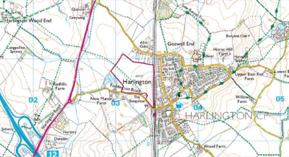
Figure 1: Extent of ALP117
3.11.2 The Bedfordshire Green Belt Study Stage 3 (ED C11) and Sustainability Appraisal (ED C31) assessed both ALP117 and the larger submission, NLP381.
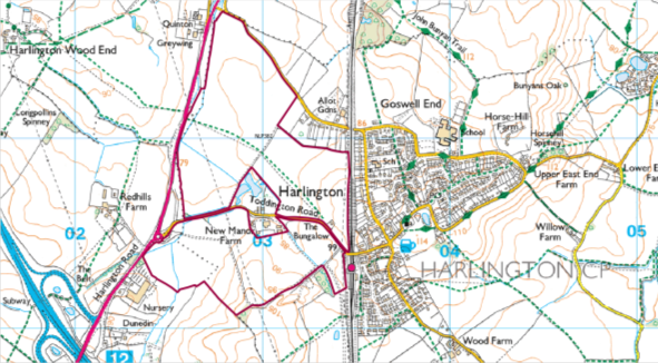
Figure 2: Extent of NLP381
3.11.3 The Stage A assessment of NLP381 highlighted concerns over the site's scale and concluded that it was too large for the surrounding area and due to other constraints, such as landscape, a portion would have to be considered. ALP117 also passed its Stage A assessment and is fully situated on the easternmost parcel of NLP381. It was decided that the extent of ALP117 would represent a suitable portion that could be allocated.
Provision of a Primary School
3.11.4 Prior to the submission of the Local Plan, it was identified by the Council's Education Team that 2.1ha of land within the site would be needed to accommodate a new 1FE Primary School to meet the needs of the site by replacing the existing Lower School in Harlington. As such, in the Council's Matter 7 Statement, and at the hearing sessions, the Council proposed an extension to the west of the site that would incorporate the 2.1ha required for the school.
3.11.5 This proposed extension raised a number of concerns that were discussed at the Examination hearing sessions and are reflected in paragraph 29 of EXAM 69. As a result of these concerns, the Council instead proposed that the primary school could be accommodated within the existing allocation. Again, some concerns were also raised with this approach, which are set out in paragraphs 30 to 33 of EXAM 69.
3.11.6 Following the hearings, further work has been undertaken by the site promoter, Willis Dawson Ltd, together with the Council, to seek to resolve the issues set out in EXAM 69. Revised master planning has been undertaken which demonstrates that a new primary school can indeed be accommodated within the existing site boundary (as in the submitted Plan). It is not considered necessary to increase the extent of the allocation, as originally proposed during the Examination hearings. Appendix 6 (EXAM 113F) of this Technical Paper includesan initial draft masterplan of the allocation provided by Willis Dawson Ltd, that identifies the proposed position of the school within the boundary of the allocation.
3.11.7 The site promoters have confirmed, through this more detailed master planning work, that the school (including associated play areas and pitches) can be accommodated without significantly reducing the capacity of the site. The initial draft masterplan demonstrates that the capacity would reduce from 435 to approximately 429 dwellings. The capacity has been able to be retained due to the removal of the provision of additional sports pitches that were previously proposed on-site. These pitches were not a requirement of the Council's Infrastructure Delivery Plan (ED C21, April 2018) and it has been confirmed by the Council's Leisure Officers that a financial contribution towards off-site provision, to upgrade existing pitches, would be acceptable. This increases the net developable area of the site.
3.11.8 The housing density has also been increased slightly. The previous master plan assumed an average density of 34 dwellings per hectare, however, Policy HA1, as drafted within the submission Local Plan allows for a density of up to 40 dwellings per hectare. This increase in the average density is agreed by the site promoters. Given this site's close proximity to Harlington Railway Station it is considered the site offers a significant opportunity for sustainable travel both to major service centres within the authority area and also further afield, which supports a higher density of development in the southern and central parts of the site. The section below relating to "Site Access" demonstrates that new residents from the site will be able to walk safely on new and improved footways to the station in under 10 minutes where there is a Thameslink train service every 15 minutes southbound to Dunstable, Luton, Luton Airport and onto London and Gatwick Airport, and northbound to Flitwick and Bedford.
3.11.9 In light of this, the Council will retain the previously proposed modification for the provision of 2.1ha of land for a new primary school on this site, as identified within the Local Plan submission document ED D05. As discussed above, however, the Council's previous intention to increase the allocation boundary is no longer necessary.
3.11.10 Bearing in mind there is no significant reduction in the yield of the site, there is no need to reconsider the benefits of the allocation against the harm to the Green Belt. The Council continues to support the conclusions made within the Initial Settlement Capacity Study (ED C42), which identifies Harlington as a Minor Service Centre, which has a medium-high growth potential. In recent years however, the settlement has seen very limited growth and HAS20 is considered to be a highly sustainable site.
Site Access
3.11.11 Paragraph 32 of EXAM 69 raises concerns with regard to access into the site (based on the boundary remaining unchanged) and in particular, access to the new school. It states that access would have to be taken from Toddington Road, which would require children and their parents using a narrow footway over the railway bridge and crossing Toddington Road on a sharp bend near the entrance to the station car park. It states that this is likely to significantly increase the risk of accidents occurring, especially during peak hours when the railway station is likely to be in frequent use by commuters.
3.11.12 Whilst detailed decisions around access arrangements and mitigation would normally be considered via the Development Management process, in response to the concerns raised, the site promoters have undertaken further technical work to review the site's accessibility. This work supplements previous evidence on the site's accessibility undertaken in consultation with the Council, as part of the emerging Development Brief for the site. A technical report together with detailed technical drawings have been prepared by the site promoter and submitted to the Council. A summary of this report together with an illustrative plan showing the proposed improvements to the site's access and the wider area, is included in Appendix 5 of this Technical Paper (EXAM 113E).
3.11.13 This work demonstrates that it is possible to improve key routes to the west of the village in order to provide suitable access for pedestrians. The main vehicular access is proposed to be taken from Toddington Road, however, a separate pedestrian and cycle only access is also proposed. In order to facilitate this, interventions are proposed to the Station Road bridge over the railway line and to Toddington Road, including footway widening, pedestrian crossing improvements and carriageway re-alignment in order to provide new improved footways. Proposals also include an extension to the 30mph speed limit on Toddington Road to the west of the site access.
3.11.14 In addition to the proposed improvements to footways and also the crossing provision in the vicinity of the station car park entrance, traffic surveys have demonstrated that the peak arrival times for commuters at the station are unlikely to clash with the times children with their parents will be walking to school. The peak vehicle movements into the station take place between 0700 and 0800 in the morning and between 1700 and 1800 in the evening. The peak pedestrian activity for accessing the school is most likely to be between 0815 and 0900 in the morning and between 1500 and 1600 in the afternoon.
3.11.15 A direct pedestrian/cycle only link onto Westoning Road, to the north of the site on land controlled by the site promoter, is also proposed together with interventions to Westoning Road itself. This includes footway widening under the rail bridge and a consistent 2m wide footway on the southern side of Westoning Road, west of the rail bridge to the proposed pedestrian/cycle access into the site. Due to the existing geography of the village, it is anticipated that at least 75% of pedestrians travelling from the village to the school are likely to use Westoning Road.
3.11.16 The pedestrian/cycle link onto Westoning Road will also facilitate sustainable trips along Westoning Road and Goswell End Road to Harlington Upper School. This will allow children to walk or cycle to the upper school from this site in approximately 15 minutes or 5 minutes respectively. Furthermore, the pedestrian/cycle link to Westoning Road offers enhanced accessibility and connectivity from the village to the remaining Green Belt land to the west of the allocation, where a connection providing enhanced accessibility to the existing wider footpath network is proposed. This is in accordance with the NPPF (2019) Paragraph 138 with regard to plan making, where it states that the plan should "set out ways in which the impact of removing land from the Green Belt can be offset through compensatory improvements to the environmental quality and accessibility of remaining Green Belt land".
3.11.17 The substantial technical work in relation to highways and sustainable access demonstrates that suitable and safe pedestrian access, to the site and in particular to the new school, can be achieved from both Toddington Road and also Westoning Road. Furthermore, the new pedestrian connections will facilitate sustainable trips from the site to Harlington Upper School, the railway station and other existing facilities within the village and also improve accessibility to remaining Green Belt land to the west.
3.11.18 An independent Road Safety Audit (RSA) has also been commissioned by the promoters of the site. The audit covered all areas relating to highway safety as referred to by the Inspectors within EXAM 69, and included the main access junction onto Toddington Road, the proposed improvements to Toddington Road, the Station Road railway bridge crossing, and the proposed works on Westoning Road. The independent RSA concluded that there were no significant safety issues from these proposals affecting either vehicular, cycle or pedestrian access into or out of the site. All the suggestions raised in the audit can be discussed in more detail and incorporated at the detailed design stage of Development Management.
3.11.19 This demonstrates the high level of detail that has gone into reviewing the accessibility of the site as part of its proposed allocation. Normally, such work would only occur later in the process when a planning application is being prepared.
3.11.20 The Council, therefore, maintains that the allocation of HAS20 is sound. Young children from within the new development and the existing village will be able to walk safely to the proposed new school within the site.
Post Examination Modifications
3.11.21 The Council is proposing to withdraw the previous modification, presented at the hearings, to amend the allocation boundary. As such, the allocation boundary would remain as submitted.
3.11.22 Modifications are proposed to Policy HA1's 'Additional Policy Requirements' for this site to reflect the need for a primary school to be accommodated on site, and to set out the need for improvements to the existing network to enable safe pedestrian and cycle access to the site, and the school in particular.
3.11.23 The proposed modifications to HAS20's Additional Policy Requirements as set out in Policy HA1 are set out below:
- Landscape buffering will be required to protect open views and create new settlement edge.
- Noise mitigation required for railway.
- Development Brief required (see HQ9).
- A site-specific FRA must be undertaken.
- Must incorporate serviced land for new lower/primary school.
- Development must include tree planting within landscape buffers to integrate development within a wider rural landscape.
- Improvements to the transport network must be made to enable safe pedestrian and cycle access into the site, and particularly the school. This must include improvements to footway provision over the railway bridge and on Toddington Road, together with the provision of safe pedestrian crossings and traffic calming measures on Toddington Road. Additional pedestrian and cycle access improvements on Westoning Road together with traffic calming of the section of Westoning Road between the railway and the Pedestrian/cycle entrance, will also be required.
3.12 HAS24 (Land South West of the A5) Hockliffe
Overview
3.12.1 HAS24 is allocated for 77 dwellings in the Local Plan, based on an area of 4.25ha. The site was submitted to the Council through the 2016 Call for Sites and was assessed as NLP327. The original submission of NLP327 was for a larger site of 24.2ha, however it was noted in the submission form that the developable area would be approximately 4ha.
3.12.2 The Council's assessment of the site considered that the total site area would be unsuitable due to its scale having a negative impact on nearby heritage assets and the wider landscape. Therefore, a portion of the site was considered acceptable. This portion was considered appropriate for allocation as it helped mitigate the constraints identified for the larger submission.
Response to EXAM 69
3.12.3 Paragraph 40 of EXAM 69 raises concern over the reduced boundary of the site (from that submitted within the Call for Sites) and what the revised boundary was based on. In this case, the site was portioned based the most suitable location to mitigate harm to surrounding constraints. In particular, the harm to the setting of several listed buildings located adjacent to the A5 and the setting of the nearby scheduled monument. The Council approached internal Conservation and Heritage specialists to determine the best position of this portion. In addition, it was noted during the assessment of the site that any portion should respect the topography of the land, to avoid too much visibility to the wider area.
3.12.4 The Council considered several different approaches towards revising the site's boundary. As Hockliffe is predominantly a linear settlement, any revised boundary that extended northwards, adjacent to existing dwellings could be seen as back land development and would have had a greater impact on the listed buildings located there.
3.12.5 A portion of the site that only included the frontage onto the A5 and did not extend further southwards beyond the existing extent of the built form was also considered. This was seen as inappropriate, as it meant reducing the capacity of the site considerably and the design of the site would mean allowing dwellings to have individual access points onto the A5 which was considered dangerous.
3.12.6 The 'L-Shaped' boundary allocated in the Local Plan was seen as the most appropriate alternative considered. Whilst its southern boundary is not based on any physical features, it was noted that the western boundary abutted a Right of Way (RoW).
3.12.7 Following the hearing sessions and receipt of EXAM 69, the Council has reviewed the evidence for this site. Officers agree that there it is difficult to justify the site. There is no defensible boundary to the south that could be used to justify the extent of the site as proposed (as required by Paragraph 85 of the NPPF). In respect of the RoW adjacent to the western boundary, it is acknowledged that this does not include any pre-existing physical barriers such as a fences or hedgerows, and instead is a vague track. As such, it is not considered to be a strong, defensible boundary, in line with NPPF guidance and the Council's Stage 3 Green Belt Study, which sets out a definition of such boundaries (ED C11, paragraph 2.36).
3.12.8 The Council does not believe there is a suitable alternative that could be considered at this stage in the plan making process. However, bearing in mind a Neighbourhood Plan is currently being developed, and via those discussions it is clear some residents are keen to see development within the area, it is considered that the allocation of specific sites within Hockliffe could be better left to the Neighbourhood Plan. A modification could be proposed to facilitate this approach.
3.12.9 The Council expects an estimated 5,505 dwellings to be provided across all small & medium site allocations. HAS24 is a small site that can provide approximately 77 dwellings, the impact of removing sites on the Plan's housing targets are considered in Chapter 4.
Post Examination Modifications
3.12.10 A modification has been proposed to remove this allocation from the Plan.
3.12.11 An additional policy is proposed, within Section 8.3 of the Plan, to enable the Hockliffe Neighbourhood Plan to release sites from the Green Belt, if required, subject to a number of specific criteria, as follows:
Within Hockliffe, amendment of the green belt boundary may be made by a neighbourhood plan to allow growth to meet local need. This is subject to:
- Sites released from the green belt must be adjacent to the existing built core of the village.
- Any such amendment and allocation of sites must be based on a robust site assessment.
- The Green Belt Stage Studies undertaken to inform the Local Plan, or any subsequent evidence or updates, must be taken into account in any site assessment process.
- Exceptional Circumstances must be demonstrated.
3.13 HAS25 (Land at Leighton Road) & HAS26 (A5 Watling Street) Hockliffe
Overview
3.13.1 HAS25 is allocated for 23 dwellings in the Local Plan, based on an area of 0.99ha. The site was submitted to the Council through the 2014 Call for Sites and was assessed as ALP125.
3.13.2 The site initially failed the first stage of the site assessment process, known as Stage A. The reason for the site's failure related to questions which tested the site's suitability within the Green Belt. This approach towards assessing sites within the Green Belt was later revised as a result of the Local Plan's Regulation 18 Consultation, whereby a number of representors highlighted issues with this approach.
3.13.3 The site was re-assessed and was considered appropriate for allocation as identified constraints on the site could be mitigated against.
3.13.4 HAS26 was allocated for 41 dwellings in the Local Plan, based on a developable area of 1.74ha and a total site area of 6.3ha. The site was not submitted to the Council through Call for Sites, it was submitted as a representation during the Local Plan's Regulation 18 Consultation. The Council reviewed this and considered the new site appropriate for further assessment as NLP538.
3.13.5 The Council considered the total site area of 6.3ha to be unsuitable for development due to the presence of important archaeology to the north and the site area being poorly related to the existing built form. It was decided a portion would be more appropriate, to improve the site's relationship with settlement pattern and avoid the area of archaeology.
Response to EXAM 69
3.13.6 It is noted within EXAM 69 that both HAS25 and HAS26 were subject to additional modelling work (completed after the submission of the Plan) to determine the extent of the previously identified flood risk.
3.13.7 A Level 2 assessment for both sites concluded that safe access and egress may not be possible and would have to be investigated further. In January 2020, the Council published a Hockliffe Flood Risk Technical Note (EXAM 92) which sets out the approach taken towards additional modelling work undertaken for both sites. This concluded that on-site flood mitigation could be provided in both cases, however, this would result in a reduced developable area and therefore, a reduction in the number of dwellings proposed. During the hearing sessions, the Council proposed to change the capacity of HAS25 and HAS26 to accommodate 14 dwellings and 27 dwellings respectively.
3.13.8 Bearing in mind the reduction in capacity of both sites, it is considered that exceptional circumstances for Green Belt release are harder to demonstrate. In view of the fact that a Neighbourhood Plan is in the process of being prepared for this area, and that the allocations made within the Local Plan allow for a substantial buffer (meaning these sites are not required to meet the Council's OAN), it is considered that the allocation of specific sites within Hockliffe would better be left to the Neighbourhood Plan.
Post Examination Modifications
3.13.9 Modifications have been proposed to remove these two allocations from the Plan.
3.13.10 As detailed in paragraph 3.12.11, an additional policy is proposed, within Section 8.3 of the Plan, to enable the Hockliffe Neighbourhood Plan to release sites from the Green Belt, if required.
[1] Whilst the Council are in agreement that it would be logical to include that land within the country park to further mitigate coalescence, this isn't possible due to the different land ownership and the aspirations of the landowner for residential development on that site.


