Proposed Main Modifications Schedule
Chapter 7 (up to HA1): Implementation
MM22
Para/Policy
Section 7.1, paragraph 7.1 – 7.2
Modification
Add new section, with subsequent numbering amendments prior to existing Section 7.1:
7.1 Housing Delivery Rates
7.1.1 The Housing Trajectory (as 01/04/2020) demonstrates that there is a total supply of 44,756 homes which will be delivered throughout the lifetime of the plan. This represents a surplus of 5,406 homes and is 14% above the Plan requirement. While there is confidence that the allocation sites will deliver, the 14% surplus in the supply will provide sufficient flexibility in the event of any delay or non-delivery.
Figure 7.1: Annual Housing Delivery
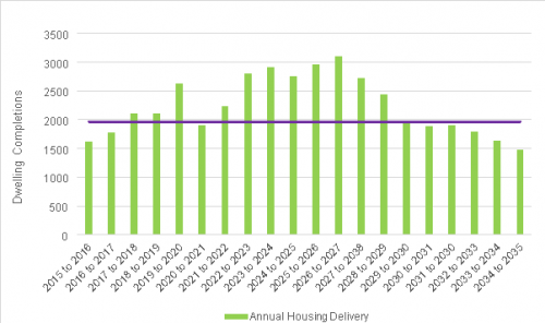
7.1.4 Figure 7.1 demonstrates that annual housing delivery has consistently increased since the beginning of the Plan period. Delivery will continue to rise due to the early delivery of a number of the small and medium allocations. Annual completions are expected to peak in the middle years when all the strategic allocations have commenced.
Figure 7.2: Cumulative housing delivery
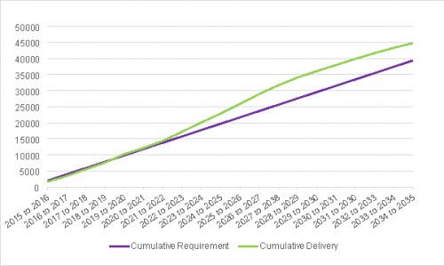
7.1.5 Figure 7.2 shows that by the end of 2019/20 delivery is expected to have exceeded requirement.
7.2 Distribution
7.2.1 This Local Plan seeks to deliver a range of housing site sizes which are distributed throughout Central Bedfordshire. This will provide choice and competition in the market and will ensure that delivery is maintained throughout the lifetime of the Plan.
Add new Table 7.1 after Paragraph 7.2.1
Table 7.1: Proposed Housing Supply across Central Bedfordshire in the Plan Period up to 2035
|
A1 Corridor |
Central |
East - West |
South |
Total |
|
|
Completions |
2,861 |
1,323 |
1,888 |
4,154 |
10,226 |
|
Existing Commitments |
3,696 |
1,313 |
3,155 |
9,306 |
17,470 |
|
New Strategic Allocations |
2,800 |
0 |
3,125 |
3,100 |
9,025* |
|
Small & Medium Allocations |
878 |
811 |
771 |
2,702 |
5,162 |
|
Sub Total |
10,235 |
3,447 |
8,939 |
19,262 |
41,883 |
|
Windfall Allowance |
2,873 |
||||
|
Total |
44,756 |
*Some strategic sites also deliver beyond the plan period (2035) refer to the Housing Trajectory (Appendix 8) for more information.
Table 7.1 2: Anticipated Delivery Rates of Strategic Sites
|
Year |
Dwelling numbers by Strategic Allocation |
|||
|
North of |
Marston Vale |
East of |
East of |
|
|
21/22 |
|
|||
|
22/23 |
|
|
||
|
23/24 |
|
|
|
|
|
24/25 |
|
|
|
|
|
25/26 |
|
|
|
|
|
26/27 |
|
300 |
|
|
|
27/28 |
|
300 |
|
150 |
|
28/29 |
|
300 |
150 |
150 |
|
29/30 |
|
300 |
150 |
150 |
|
30/31 |
|
300 |
150 |
150 |
|
31/32 |
|
300 |
150 |
150 |
|
32/33 |
|
300 |
150 |
150 |
|
33/34 |
|
300 |
150 |
|
|
34/35 |
|
300 |
150 |
|
|
POST |
|
|
|
0 |
Justification
For clarity and effectiveness
MM23
Para/Policy
Section 7.2, paragraph 7.2.4
Modification
Add new paragraph 7.3.4 following Paragraph 7.2.4 (to be Section 7.3):
7.3.4 At 1st April 2020, Central Bedfordshire was able to demonstrate a five-year supply of 6.18 years against the Plan requirement of 39,350. The derivation of this supply is set out below;
At April 2020, a total of 10,226 new homes have been delivered in Central Bedfordshire since the start of the Plan period. This is 388 more than was required over the same period. As there has been an over delivery, there is no shortfall to be added to the five-year requirement.
39,350 – 10,226 = 29,124
29,124/15 (years remaining) = 1941.6
1941.6 x 5 = 9,708
After a 5% buffer is added, the five-year supply requirement at April 2020 is 10,193.
The Trajectory identifies a five-year supply of 12,609 which equates to 6.18 years and is a surplus of 2,416 homes.
Justification
To provide clarity to users of the Plan
MM24
Para/Policy
Section 7.5, paragraph 7.5.2
Modification
Add new paragraph 7.6.3 following Paragraph 7.5.2 (to become Section 7.6)
7.6.3 Strategic scale residential led developments will be delivered in phases over a number of years. The viability of a scheme is likely to change over the lifetime of the development, in terms of the costs associated with developing the site and sales values. This may impact on the ability of the site to deliver the infrastructure required to support the development. The Council may require review mechanisms to address any economic uncertainties over the lifetime of the development. These provisions will form part of a Section 106 agreement and the trigger for a review of viability will be agreed between the Council and the applicant.
7.5.3 6.4
Justification
For clarity and effectiveness
MM25
Para/Policy
7.4
Modification
The Key Diagram. An updated version of the key diagram is shown below:
As submitted:
%20MM25.png "7.4 Original Key Diagram")
As proposed for modification:

Justification
For clarity and effectiveness
MM26
Para/Policy
Policy SP3
Modification
Policy SP3: Generic Requirements for Strategic Sites Housing Allocations:
Development proposals bought forward at the identified strategic allocations should be accompanied by comprehensive Development brief for the whole site. The strategic housing allocations and commitments identified in this Plan will be required to meet Proposals should be based on the following requirements and objectives:
- Creation of distinctive, well integrated new communities which respect their local context, enhance the standards of sustainable design in the locality and relate well to neighbouring settlements;
- Preparation of a
comprehensive masterplanDevelopment Brief for the whole site which includes an indicative layoutconcept plan and an indicative phasing plan. Themasterplanconcept plan should reflect the location of the site, incorporate the highest standards of design and make effective use of the site through application of appropriate densities, layout and form; - Meeting the housing needs of all sectors of the community including families, the young and older people and to match house types to the local employment base in order to reduce the need for out commuting;
- Provision of a local centre for the new community, with a range of facilities to meet local needs including small-scale employment uses, preschool facilities, and primary education, including provision for health and social care in the locality. Integrated Health and Care Hubs should be located in close proximity to schools and elderly persons accommodation and provided early in the development programme;
- Provision of a Sustainable Transport Strategy, fully integrated into the overall masterplan and demonstrating improved linkages to existing transport nodes
e.g.such as mainline rail stations by sustainable means and how the development will reduce the need to travel by car. Measures to mitigate the traffic impacts of the proposed development on the strategic and local road networks together with footpaths, cycleways, bridleways, and green corridors should be included; - Promoters should undertake a full Transport Assessment to ensure that the package of mitigation measures are incorporated into the scheme, including pedestrian and cycle links, a public transport strategy and any offsite contributions as deemed necessary. Due regard should be given to the phasing of the scheme and the delivery of strategic and non-strategic transport infrastructure projects;
- A strategy for the conservation, protection and enhancement of the historic environment shall be developed and implemented. The strategy will include measures to avoid harm to the historic environment, and where harm cannot be avoided mitigate any harmful impacts, using information derived from site specific heritage impact assessments;
- A Green Infrastructure Strategy which
sets outidentifies measures to protect and enhance any environmentally sensitive areas within and around the site, avoid harmful impacts and mitigate the local and wider impacts of the development, including phasing of these measures and their long term management, and to maximise the opportunities presented by undevelopable land; - Where appropriate, the development should provide a fully integrated Sustainable Drainage System to mitigate against any potential flood risk, apply a flood risk sequential approach to development across the site;
Detailed viability information including aThe submission of an infrastructure phasing and delivery plan.
Where a site is not policy compliant, the submission of detailed viability information will be required, and the Council will seek review mechanisms to assess the viability of the strategic site throughout the timescale of the development.
Justification
To improve plan clarity and following discussing at the Hearings.
MM27
Para/Policy
Section 7.6
Modification
Delete Section 7.6 in its entirety.
7.6 What are Integrated Health and Care Hubs?
- Integrated Health and Care Hubs will support the local ambition for access to modern, high quality and locality based health and care services. These Hubs will be aligned to key Spokes in our rural communities. Central Bedfordshire population distribution and its relation to secondary care providers makes it imperative that the importance of the Integrated Health and Care Hubs approach is sustained. Services need to be more accessible to people, especially in predominantly rural areas, and should meet the requirements for delivering health and care services to an expanding and ageing population.
- More services will be accessible to people where they live, whilst also enhancing community based and out of hospital services. These Hubs are important in helping to meet the complex needs of an ageing and growing population, in a predominantly rural area without its own district general hospital.
- The integrated Health and Care Hubs will be the main centres for providing proactive and preventative care, out of hospital services and care packages for people who are vulnerable or have complex care needs. These Hubs will help to reshape the primary model which delivers primary care at scale, addressing the issue of capacity in general practice and ensuring equitable and timely access to care.
- A locality based integrated health and care hub approach improves cooperation and joined up working which improves the access and quality of care provision. It also leads to a reduction of inappropriate hospital admissions and importantly supports the vision for integrated primary and community services at scale as set out in the General Practice Forward View.
- As a minimum, these Health and Care Hubs are expected to serve as a base for the multi-disciplinary teams (adults and children's) being established as part of the community services redesign programme, including general medical services where possible. The co-location of health and care teams in fit for purpose facilities is central to managing demand and ensuring the future sustainability of local health and care systems.
-
Each Integrated Health and Care Hub will provide local access to a range of general medical and nursing, therapy, specialist and social care services with supporting information and advice systems. The Health and Care Hubs may also develop a range of additional or enhanced services in line with the needs of the local community. Enhanced services might include
- Extended GP services on a 7 day basis
- Enhanced services delivered by and across practices, e.g. minor injury and minor illness services, clinics to support patients with long-term conditions
- Face-to-face out of hours consultations
- Community pharmacy
- Rehabilitation and re-enablement facilities
- Outreach services from local acute hospitals and specialist services, e.g. outpatient appointments and other specialist consultations
- Less complex diagnostics
- Public Health and prevention services, e.g. smoking cessation, NHS Health Checks, lifestyle hubs
Justification
Moved to chapter 17 for effectiveness
MM28
Para/Policy
SA1
Modification
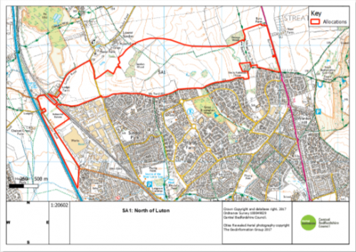
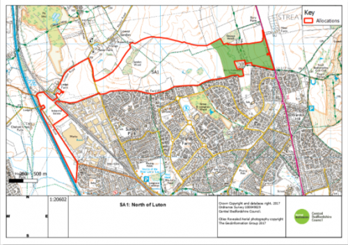
Policy SA1: North of Luton
Land to the north of Luton, as identified on the Proposal Policies Maps, is allocated for a mixed-use development consisting of up to 4000 approximately 3,600 dwellings and a minimum of 20 hectares approximately 7 hectares of employment land for a mix of B1E(g), B2 and B8 uses.
Proposals for development within the area identified as the 'Eastern Bowl' on the Policies Map, will only be acceptable where additional evidence demonstrates that any impacts on the Chilterns AONB and heritage assets and their settings can be avoided, and if this is not possible, satisfactorily mitigated. The type and amount of development in the Eastern Bowl, and indicative mitigation measures, will be confirmed in the Development Brief.
Development proposals in the Strategic Land Allocation will be permitted in accordance with other relevant policies in the Development Plan and where the principles set out below are met. These principles will be defined in more detail through the preparation of a Development Brief which will include a concept plan and an indicative phasing plan. Planning permission will only be granted for development following the Council's adoption endorsement of this Development Brief. A site wide Design Code(s) will also be required, followed by area specific Design Codes for each phase, to be prepared by the developer and approved by the Council.
In order to ensure the development will be supported by the local and strategic infrastructure needed to ensure sustainable development, in the context of pooling restrictions and multiple landownerships, the Council will refuse any piecemeal planning permission that would undermine the Councils ability to deliver the required infrastructure.
The principles of the development are:
- The development will form a well designed, sustainable urban extension to Luton that will provide a mix of uses necessary to achieve a sustainable and vibrant community, including:
in the region of 4000up to 3,600 homes with an appropriate balance and mix of residential accommodation to meet identified needs, which shall include subject to viability, a policy compliant mix of affordable housing,starter homes,self/custom build plots and a mix of homes to meet all identified needs for older people;a minimum ofup toapproximately 720hectares of new non strategic employment land to contribute towards meeting local employment needs, focused primarily to the west of the allocation site and centred around the new M1 Junction 11a to maximise access to the M1 and create an employment hub that compliments the new employment uses at North Houghton Regis and Sundon RFI (Policy SE1). The 7ha requirement is in addition to completed employment land at Panettoni Park, adjacent to the M1;provideprovision of the serviced land necessary to deliver a healthcareand social care hubfacility within the site to serve the identified health and social care needs of the proposed developmentand the needs of the catchment area of that facilityand a commensurate financial contribution towards the delivery of that facility;-
provision of new community facilities in accordance with Policy
HQ2HQ3,includinga mix of retail and at least one drinking establishment to serve the existing and new communities everyday needs; - provision of new educational facilities, comprising day nurseries, early years, primary, secondary and sixth form facilities to meet the identified needs of the development or equivalent facilities to meet the educational and childcare needs arising from the development; and
- provision of leisure facilities, including:
-
indoor sport and leisure facilities, in accordance with Policy
HQ3HQ4; and -
outdoor sport, leisure and open space, in accordance with Policy
iesEE12EE13, including pavilions and allotments.
-
It is critical that development of this site isThe development will be required to be supported by a comprehensive scheme of highway improvements to mitigate the impacts of the development on the existing network within Central Bedfordshire and Lutonincluding an appropriately designed a routed new road to link the A6-M1 Junction 11a,. It is essential that the development contributes to the delivery of and is served by the M1-A6 Link Road as well as the existing roads into the North of Luton and the development shall provide the land and commensurate financial contributions towards its delivery.
-
The development will be phased in accordance with the timing of supporting infrastructure and community facilities including the delivery of the Link
rRoad, which shall be delivered as soon as viably possible.The phasing of the road will commence from the west, with the first phase a dual carriageway between M1 Junction 11a and Sundon Park Road to facilitate access to the first phase of development and Sundon RFI employment allocation;
-
The development will provide other supporting transport infrastructure,
includingwhich will include, where necessary, proposals to mitigate the impact of traffic associated with the development within Central Bedfordshire and Luton. Within Luton, appropriate transport mitigation schemes will be required at Marsh Road/Bramingham Road/Sundon Park Road; Barton Road/Icknield Way; and Barton Road/Birdsfoot Lane.including providing foreEfficient public transport routes through the developmentthatwill link with key destinations including Leagrave Train Station and Luton town centre, and to the Luton and Dunstable Guided Busway;
-
The development shall integrate and connect to existing public rights of way within and adjoining the site to provide routes to the wider countryside and neighbouring settlements. The development shall include a cycleway connection to route 6 of the national cycleway network.
and will be required to provide new crossings on the A6 and crossings over the new link road to improve and maintain connections; it is essential that the development contributes towards the delivery of and is served by an appropriately designed and routed new link road between the A6 and M1 Junction 11a;
- The development shall provide dedicated and safe pedestrian and cycle links from the new and existing neighbourhoods to local centres, employment opportunities, schools, shops and community facilities; both within the allocation and the wider Luton conurbation;
- The development shall maximise opportunities to create Green Infrastructure corridors through the site linking with existing Green Infrastructure assets, including a link between Bramingham Park and George Wood; and a link between Bramingham Wood and Sundon Wood, beneath the current alignment of the pylon lines. The development shall also provide a green corridor along key routes including the setting of the Theedway and appropriately designed Green Infrastructure to mitigate visual impacts upon the setting of the AONB and the significance of heritage assets;
- The development shall provide appropriate mitigation, compensation and/or enhancement of key features of biodiversity to ensure a net gain for biodiversity including but not limited to:
- Sundon Wood CWS, Bramingham Wood CWS, Sunshine Riding Stables CWS, Sundon Quarry SSSI and CWS, Galley and Warden Hills SSSI and CWS, Sundon Country Park CWS and Barton Hills National Nature Reserve SSSI; and
- Identified protected species and priority habitats;
-
The development shall ensure that the design and construction of the development as a whole including the A6 to M1 junction 11a link road has no undue impact on the AONB, heritage assets and biodiversity and provides for the mitigation and enhancements where feasible. With the exception of the link road and major built development within the AONB shall require exceptional circumstances to be demonstrated and shall only be permitted where it can be demonstrated it is in the public interest.
-
The development will ensure that any impact on non designated heritage assets witharchaeological interest is mitigated in order to record and advance understanding ofany heritage assets affected by the development. The mitigation will include makingthe results of all archaeological investigations publically available for the benefit forthis and future generations.The design and construction of the development shall provide appropriate mitigation against any impacts, and make enhancements to, the Chilterns AONB, heritage assets and their settings and biodiversity, where necessary.
-
The site is in an area with a rich and varied historic environment. Parts of the site are within the setting of designated and important non-designated heritage assets, including:
- Drays Ditches, Streatley (Scheduled Monument);
- The Galley Hill Round Barrows, Streatley (Scheduled Monument);
- The Church of St Mary in Sundon (Grade I listed building);
- St Mary's Vicarage (Grade II listed building);
- Aubers Farmhouse (Grade II listed building);
- Chestnut Cottage (Grade II listed building);
- The landscape associated with Sundon Manor (which is also known as Sundon Park).
The site is also known to contain non-designated heritage assets with archaeological interest.
-
The development will be designed to mitigate any harm caused to the significance of all designated heritage assets within the site boundary and the setting of all designated heritage assets which lie within the site's vicinity. The development will not result in the destruction of any designated heritage assets or their settings and shall deliver mitigation measures that preserve all designated heritage assets and their settings for future generations. This is required in order to ensure that the public benefits of the development outweigh the degree of harm caused to the significance of all designated heritage assets affected by the development.;Any future development at this site must ensure it accords with the Historic Environment policies of this Plan (HE1, HE2 and HE3) and the requirements of the NPPF. Any future development proposals will take into account a Heritage Impact Assessment for the site or relevant phase, agreed between the developer and the Council, in consultation with Historic England. Indicative mitigation measures will be identified within the Development Brief, specific mitigation measures will be identified through the Design Coding process. Where preservation in situ of archaeological remains within areas of open space is proposed, any landscaping schemes will be designed to ensure that there is no damage to the heritage assets with archaeological interest.
-
Subject to the findings of the site specific flood risk assessment the development shall deliver strategic measures to reduce flood risk including the use of sustainable drainage methods (SUDS) in line with Policy CC5.
to attenuate and discharge surface water run-off at reduced rates, and at least at a rate no greater than if the site were undeveloped and to reduce existing downstream risk. This may include consideration of "off-site" solutions. The development and strategic measures will be designed to ensure there no detrimental impact on groundwater flooding downstream and shall seek to intercept and store surface water flows on site. Regard shall be had to the phased delivery of flood mitigation and SUDS in accordance with the phasing of the development to ensure adequate measures to reduce flood risk (from all sources) are provided throughout the lifetime of the development. The detailed designs of sustainable drainage systems maximise biodiversity enhancement, mitigation of visual landscape impacts, maintenance and safety, when considering their location and relationship to neighbouring uses. Safe access and egress shall be provided taking account of the flood risk at the site.
-
The developmentFoul drainage from the development shall be connected to the mains sewerage network. The development shall demonstrate that there is adequate capacity in the water recycling centre (sewage treatment works) and the foul sewerage network to serve the proposed development, and that it will not have an adverse impact on surface or ground water in terms of quality and quantity.and aAny application for planning permission shall detail any infrastructure upgrades where required and any necessary phasing arrangements as agreed by the relevant sewerage company;
- The development will respect the Chilterns AONB its setting and shall provide appropriate landscaping measures to create a sense of place, provide a net gain for biodiversity and shall mitigate the potential impact of development on the wider landscape, including the AONB. Specific mitigation will be identified through detailed masterplanning and confirmed in the Development Brief and/or future planning applications. To mitigate harm to the AONB the development shall provide significant landscape enhancements on and beyond the northern allocation boundary and shall create a long term defensible Green Belt boundary as informed by detailed assessments. Noise attenuation fencing to mitigate noise impacts from the new link road will be resisted.
- Incorporate measures to adapt to climate change, minimise energy use and include renewable energy technologies in accordance with policies CC1, CC2, CC3 and CC5, and any other relevant policies in the Plan.
The revised Green Belt boundary follows the extent of the allocation boundary.
Justification
To ensure that the policy is effective, justified and consistent with national planning policy
MM29
Para/Policy
SA1
Modification
The boundary of the map on page 57 of the plan is updated to reflect the suggested change to the site boundary following the M1-A6 Link Road at the eastern end of the site and to identify the eastern bowl area. This is shown below:
As submitted:
As proposed for modification:
Justification
MM30
Para/Policy
SE1
Modification
Policy SE1: M1 Junction 11A – Sundon Rail Freight Interchange (RFI)
The land designated for Sundon RFI, as identified on the Proposal Policies Map, will provide a Rail Freight Interchange alongside new employment land.
Development proposals will be permitted where they:
- provide an intermodal rail facility on approximately 5 hectares of the site;
- provide for approximately 40 hectares of new employment land accommodating B8 warehousing and distribution uses;
-
are directly
beconnected to M1 Junction 11a by the Integral Spur and M1-A6 Link Road; - provide a commensurate financial contribution to the essential delivery of the M1-A6 Link Road and the provision of the Integral Spur, connecting Sundon Road to the M1-A6 Link Road;
-
deliver a connection from the Integral Spur to the RFI
by an appropriate new strategic road link between Sundon Park Road and M1 Junction 11a; - deliver strategic tree planting along the western boundary, and throughout the site, to aid screening and contribute to a net gain in biodiversity;
- enhance and manage the adjoining Sundon Chalk Pits CWS and Sundon Chalk Quarry SSSI to improve their ecological value and contribute to the GI network;
-
preserve and enhance heritage assets and their settings within and around the site;
and -
provide
give due consideration toan appropriate realignment of the Chiltern Way; and - provide opportunities for sustainable transport links to be determined through a Transport Assessment.
SE1 has the potential to contain heritage assets with archaeological interest; therefore the impact of any future development on sub-surface archaeological remains must be avoided, and if this is not possible, mitigated.
A site-specific Flood Risk Assessment will be required and a sequential approach to site layout will be encouraged, to steer development away from areas of flood risk on the site. Subject to the findings of the flood risk assessment the development shall deliver strategic measures to reduce flood risk, including the use of Sustainable Drainage methods.
Development will be permitted in accordance with other relevant policies in the Development Plan and following the successful preparation of a Master plan.
The on-site rail infrastructure and operational intermodal terminal should be constructed during the first phase of development. No more than 40,000sqm of warehousing shall be occupied until the rail connection, including signaling, sidings and locomotive run-round loop as required by Network Rail, has been constructed, commissioned and is available for use.
The Green Belt boundary follows the extent of the RFI and employment allocation. The CWS and SSSI will remain in the Green Belt.
Justification
To ensure that the policy is effective, justified and consistent with national planning policy
MM31
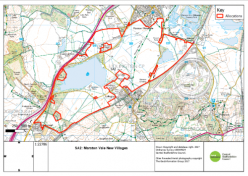
Para/Policy
SA2
Modification
Policy SA2: Marston Vale New Villages
The land for Marston Vale New Villages, as identified in the Proposal Policies Maps, is allocated for a mixed-use development comprising of up to approximately 5,000 dwellings and a minimum of approximately 30 40 hectares of employment land. The employment land is intended allocated for new non strategic E(g) B1, and B2 and B8 uses, intended specifically for employment relating to research and development, office, distribution, services and tourism to contribute towards meeting local employment needs.
Development proposals in the Strategic Land Allocation will be permitted in accordance with other relevant policies in the Development Plan and where the principles set out below are met. These principles will be defined in more detail through the preparation of a Development Brief which will include a concept plan and an indicative phasing plan. Planning permission will only be granted for development following the Council's adoption endorsement of this Development Brief. A site wide Design Code(s) will also be required, followed by area specific Design Codes for each phase, to be prepared by the developer and approved by the Council.
In order to ensure the development will be supported by the local and strategic infrastructure needed to ensure sustainable development, in the context of pooling restrictions and multiple landownerships, the Council will refuse any piecemeal planning permission that would undermine the Councils ability to deliver such infrastructure.
The principles of the development are:
-
The development will form a series of
up to fournew villages appropriately separated and screened from neighbouring settlements byappropriategreen and blue infrastructure. The villages will provide a mix of uses necessary to achieve a sustainable and vibrant network of communities. Development will include:
-
Approximately 5,000 homes across a series of
up to fournew villages with an appropriate balance and mix of residential accommodation to meet identified needs. This mix shall include, subject to viability, a policy compliant mix of affordable housing,starter homes,self/custom build plots and a mix of homes to meet all identified needs for older people; -
A minimum ofApproximately 3040hectares of employment land, to satisfy identified needs for Research and Development, office,distribution,services and tourism. This employment should be well-integrated with the villages, both in terms of design and pedestrian and cycle access. -
provideProvision of a suitable parcel of serviced land and commensurate financial contributionstowards the delivery of a primary healthcare facility to be delivered on site and the provision of a commensurate financial contribution towards the delivery ofahealth and social carefacility to serveservices to meet the healthcare needs of the development. -
Provision of new community facilities in accordance with Policy
HQ2HQ3,includinga mix of retail, a community library space and at least one drinking establishment to serve the existing and new communities everyday needs; -
Provision of new educational facilities
,comprising: day nurseryiesfacilities, early years,lower, middle, upperprimary school, secondary school and sixth formfacilitiesto meet the identified needs of the development or equivalent facilities to meet the educational and childcare needs arisingformfrom the development; and -
pProvision of leisure facilities, including:- indoor sport and leisure facilities, in accordance with Policy HQ3; and
-
outdoor sport, leisure and open space, in accordance with Policy
iesEE12EE13, including pavilions and allotments.
-
The development shall provide dedicated and safe pedestrian and cycle links between the new and existing villages, connecting new local centres, employment opportunities, schools, shops, public transport nodes and community facilities with existing pedestrian and cycle networks in
withinthe wider Marston Vale.
-
The development shall maximise opportunities to create Green Infrastructure corridors. The allocation is expected to deliver a multifunctional Green Corridor through the entire length of the site to form the Bedford and Milton Keynes Waterway Park. The development will deliver a water-filled and navigable link to facilitate a waterway connection between
connectingBrogborough and Stewartby Lakes. The developmentandshall deliver a cycleway within the Bedford and Milton Keynes Waterway Park Green Corridor. This will form part of a cycleway connection betweenfromStewartby Laketoand Ridgmont Railway Stationfollowing the route of the Green Corridor.
-
The development shall provide appropriate mitigation, compensation and/or enhancement of key features of biodiversity including but not limited to, identified protected species and priority habitats.
ExistingKey ecological features should be protected, well buffered and connected with additional habitat creation and linkages.Open water habitats in derelict brick pits provide valuable habitats for GCN,pPotential detrimental impacts on wet habitats valuable for Great Crested Newts or other flora and fauna must be avoided through careful zoning of uses or, where it is ecologically acceptable, habitats may be compensated through the creation of new ponds and wetland features.
-
The development shall provide appropriate landscape
ingmeasures to create a sense of place, provide a net gain for biodiversity andshall mitigateinclude mitigation to address the potential impact of development on the wider landscape. The site is within the Forest of Marston Vale, and therefore any development mustprovide a total of 30% tree covercomply with Policy EE9.
-
The development will ensure that any impact on non designated heritage assets with archaeological interest is mitigated in order to record and advance understanding of any heritage assets affected by the development. The mitigation will include making the results of all archaeological investigations publicly available for the benefit for this and future generations; The site is in an area with a rich and varied historic environment. Parts of the site are within the setting of designated heritage assets, including:
- The medieval village and moated sites at Thrupp End, Lidlington (Scheduled Monument);
- Moat Farm moated enclosure and associated settlement earthworks, Marston Moretaine (Scheduled Monument);
- The medieval Ringwork at the Round House, Brogborough Park Farm (Scheduled Monument);
- The Church of St Mary the Virgin, Marston Moretaine (Grade I listed building);
- The Tower belonging to the Church of St Mary, Marston Moretaine (Grade I listed building);
- Moat Farmhouse, Marston Moretaine (Grade II* listed building);
- Thrupp End Farmhouse, Lidlington (Grade II listed building);
- The Round House, Brogborough Park Farm (Grade II listed building)
The site is also known to contain non-designated heritage assets with archaeological interest.
-
The development will be designed to mitigate any harm caused to the significance of all designated heritage assets in the vicinity of the site. The development will not result in the destruction of any designated heritage assets or their settings and shall deliver mitigation measures that preserve all designated heritage assets and their settings for future generations. This is required in order to ensure that the public benefits of the development outweigh the degree of harm caused to the significance of all designated heritage assets affected by the development;Any future development at this site must ensure it accords with the Historic Environment policies of this Plan (HE1, HE2 and HE3) and the requirements of the NPPF. Any future development proposals will take into account a Heritage Impact Assessment for the site or relevant phase, agreed between the developer and the Council, in consultation with Historic England. Indicative mitigation measures will be identified within the Development Brief, specific mitigation measures will be identified through the Design Coding process. Any landscaping schemes proposed must also seek to safeguard existing tree lines/hedgerows. Where preservation in situ of archaeological remains within areas of open space is proposed, any landscaping schemes will be designed to ensure that there is no damage to the heritage assets with archaeological interest.
- The development shall be designed to ensure that uses and developments within the site that are vulnerable to flood risk are located outside of areas of flood zones 2 and 3 and areas at high risk of surface water flooding. Flood capacity shall be retained on site.
-
The development will, through the creation of the Bedford and Milton Keynes Waterway Park, provide a link for moving water between Brogborough and Stewartby Lakes contributing, where possible, to water management objectives at the catchment scale
, to increase the strategic flood storage capacity across the Marston Vale.
-
Subject to the findings of the site specific flood risk assessment the development shall deliver strategic measures to reduce flood risk including the use of sustainable drainage methods (SUDS) in line with Policy CC5.
to attenuate and discharge surface water run-off at reduced levels where possible, and at least at a rate no greater than if the site were undeveloped and to reduce existing downstream risk. Regard shall be had to the phased delivery of flood mitigation and SUDS in accordance with the phasing of the development to ensure adequate measures to mitigate flood risk (from all sources) are provided throughout the lifetime of the development. The detailed designs of sustainable drainage systems should maximise biodiversity enhancement, mitigation of visual landscape impacts, flood risk reduction, maintenance and safety, when considering their location and relationship to neighbouring sites and uses.SuDS will be designed as part of the green infrastructure network, enhancing existing watercourses and drainage features, and integrating then with the Bedford and Milton Keynes Waterway Park where appropriate. Safe access and egress shall be provided taking account of the flood risk at the site.
-
The development shall integrate,
andconnect to, and improve alignments of existing public rights of way within and adjoining the site to provide routes within the development to the wider countryside and neighbouring settlements,. In addition to these routes, the development will enable a cycle and pedestrian connections to be madeincluding a cyclewaybetween Stewartby Lake and Ridgmont Railway Station which shall include appropriately designed crossings over the waterway.
-
The development will provide supporting transport infrastructure to mitigate the impact of traffic associated with the development, including
commensurate financial contributions towardsa deliverable schemeforof improvements at J13 of the M1 and improvements to theMarsh Leys roundaboutstrategic and the local highway network as necessary, to mitigate the impacts of development. The development shall deliver viable and efficient public transport routes and segregated cycling routes through the development that enable links with key destinations including the nominated East West Railat Ridgmont Trainstopping station and employment areas.
-
The development shall provide commensurate contributions towards the provision of appropriate off-site infrastructure improvements including towards public transport interchange facilities relating to the enhancement of
enhancing the infrastructure atRidgmont Railway Stationthe nominated stopping station for East West Rail, including Public Transport interchange facilities and car parking;
-
Foul drainage from the development shall
willbe connected to thepublicmains sewerage network. The development shall demonstrate that there is adequate capacity in water recycling centre (sewage treatment works) and the foul sewerage network to serve the proposed development and that it will not have an adverse impact on surface or ground water in terms of quality and quantity. Any application for planning permission shall detail any infrastructure upgrades where required and any necessary phasing arrangements as agreed by the relevant Water and Sewerage Company;
- The development will incorporate measures to adapt to climate change, minimise energy use and include renewable energy technologies in accordance with policies CC1, CC2, CC3 and CC5, and any other relevant policies in the Plan.
- The development shall be accompanied by a Mineral Resource Assessment in accordance with Policy MPS11 of the Minerals and Waste Local Plan (January 2014)
- The development will be required to respond appropriately to its location within the Health and Safety Executive Major Accident Hazard Pipelines Consultation Zone and identify mitigation measures where necessary.
Justification
To ensure that the policy is effective, justified and consistent with national planning policy
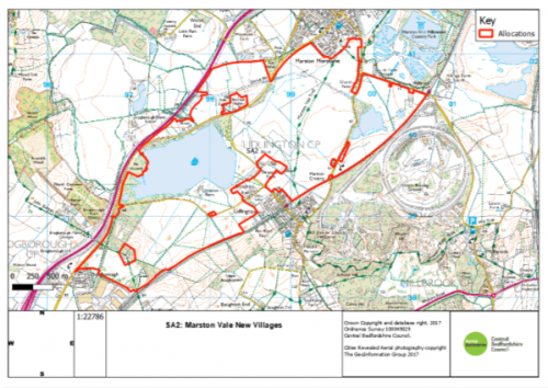
MM32
Para/Policy
SA2
Modification
The boundary of the map on page 64 of the plan is updated to reflect the suggested change to the site boundary to remove a small parcel of land adjacent to Brogborough Village. This is shown below:
As submitted:
As proposed for modification:
Justification
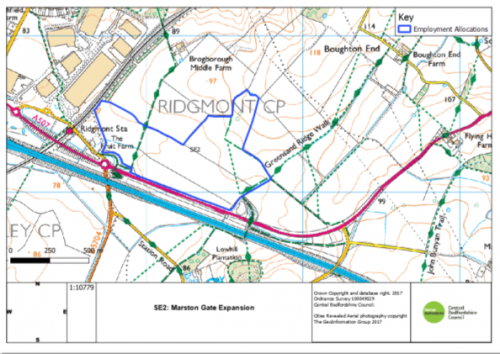
MM33
Para/Policy
SE2
Modification
Policy SE2: M1 Junction 13 – Marston Gate Expansion
The land allocated for The Marston Gate Expansion, as identified on the Proposal Policies Map, will provide new employment floorspace.
Development proposals will be permitted where they:
- provide up to 30 hectares of new employment land and 5 hectares of screening and landscaping;
-
deliver a mix of uses including B2 and B8 warehousing and distribution with associated
B1E(g) and ancillary uses, and a lorry park with associated E(b)A3food and drink uses;and a lorry park -
facilitate necessary mitigation and improvements to the A507 and M1, including M1 Junction 13, to ensure the site is well connected to the strategic transport network;
and - provide opportunities for sustainable transport links to be determined through a Transport Assessment and accompanying Travel Plan; and
- deliver strategic measures to reduce flood risk, including the use of SUDS to attenuate and discharge surface water run-off at reduced rates, at least at a rate no greater than if the site were undeveloped and to reduce existing downstream risk. This may include consideration of off-site solutions;.
- Provide appropriate landscaping and open space in the northernmost section of the site where the land rises at the edge of the Greensand Ridge, to ensure effective integration with the open countryside beyond the site.
Across the development, all buildings will have a maximum height of 18.5m and must include :
- the use of multi-barrel vaulted roof profiles which replicate those within the existing Marston Gate site (the Amazon, XPO and Dwell units) but with a further softened roof line to contribute to a reduction in the visual height of buildings with reduced eaves and no parapets;
- the use of colour banding and darker shades at lower levels, to add gravitas to the base of the building, with colours lightening up the elevations. The colour palette, which will be agreed with the Council, may consist of browns, greens and greys to aid the buildings integration into the surrounding landscape; and
- the use of targeted off-site planting to be agreed with the Council and relevant landowners, to aid with mitigating key views.
Appropriate measures should be taken to ensure the proposals take full account of the potential arising from improvements to Ridgmont rail station, to maximise sustainability and sustainable transport options. Proposals will provide commensurate contributions towards enhancing the infrastructure at Ridgmont Railway Station, including public transport infrastructure facilities and car parking facilities.
SE2 is in an area with a rich and varied historic environment. It lies within the setting of a number of designated heritage assets, including Conservation Areas and:
- The medieval Ringwork at the Round House, Brogborough Park Farm (Scheduled Monument);
- The Round House, Brogborough Park Farm (Grade II listed building);
- All Saints Church, Segenhoe (Scheduled Monument and Grade II* listed building);
- Segenhoe Manor (Grade II* listed building)
- Parish Church of St James, Husborne Crawley (Grade II* listed building);
- Malting Spinney Moat (Scheduled Monument); and
- Woburn Abbey (Grade I Registered Park and Garden)
SE2 is also known to contain non-designated heritage assets with archaeological interest. Any future development at this site must ensure it accords with the Historic Environment policies of this Plan (HE1, HE2 and HE3) and the requirements of the NPPF. Specific details regarding the siting; scale, colour and massing of the buildings and the landscaping scheme will be agreed through a site-specific Design Code to be submitted and approved by the Local Planning Authority.
Development will be permitted in accordance with other relevant policies in the Development Plan and following the successful preparation of a Design Code which provides an exemplar design response to this unique gateway location.
Justification
To ensure that the policy is effective, justified and consistent with national planning policy
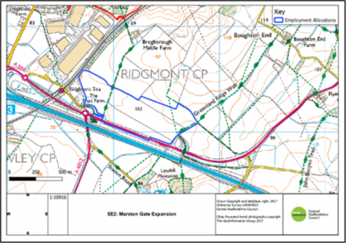
MM34
Para/Policy
SE2
Modification
The boundary of the map on page 67 of the plan is updated to reflect the suggested change to the site boundary to remove the rising ground to the north of the site. This is shown below:
As submitted:
As proposed for modification:
As proposed for modification:
Justification
MM35
Para/Policy
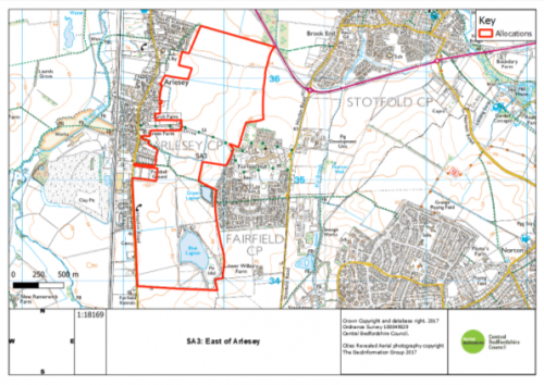
SA3
Modification
Policy SA3: East of Arlesey
Land to the east of Arlesey, as identified on the Proposal Policies Maps, is allocated for a housing-led development consisting of up to approximately 2000 dwellings, a relief road and a country park.
Development proposals in the Strategic Land Allocation will be permitted in accordance with other relevant policies in the Development Plan and where the principles set out below are met. These principles will be defined in more detail through the preparation of a Development Brief which will include a concept plan and an indicative phasing plan. Planning permission will only be granted for development following the Council's adoption endorsement of this Development Brief. A site wide Design Code(s) will also be required, followed by area specific Design Codes for each phase, to be prepared by the developer and approved by the Council.
In order to ensure the development will be supported by the local and strategic infrastructure needed to ensure sustainable development, in the context of pooling restrictions and multiple landownerships, the Council will refuse any piecemeal planning permission that would undermine the Councils ability to deliver such infrastructure.
The principles of the development are:
- The development will form a well-designed sustainable urban extension to Arlesey that will provide a mix of uses necessary to achieve a sustainable and vibrant community, including:
-
in the region ofapproximately 2000 homes with an appropriate balance and mix of residential accommodation to meet identified needs, which shall include subject to viability, a policy compliant mix of affordable housing,starter homes,self/custom build plots and a mix of homes to meet all identified needs for older people;a country park on the eastern edge of the development to retain an appropriate separation between Arlesey and Fairfield Park and to provide a net gain in green infrastructure and biodiversity;
- provide the serviced land necessary to deliver a health care facility within the site to serve the health needs of the proposed development and the needs of the catchment area of that facility and a commensurate financial contribution towards the delivery of that facility;
-
provision of new community facilities in accordance with Policy
HQ2HQ3 including community centres, a mix of retail and at least one drinking establishment to serve the existing and new communities everyday needs; - Educational facilities, comprising day nurseries, early years, new school(s) for primary aged children to meet the identified needs of the development (or equivalent facilities to meet the educational and childcare needs arising from the development) and financial contributions towards the provision, improvement, enlargement or enhancement of schools for secondary aged children and sixth form facilities off site to meet the identified needs of the development (or equivalent contributions towards projects to meet the educational needs arising from the development); and
-
provision of leisure facilities, including:
-
indoor sport and leisure facilities, in accordance with Policy
HQ3HQ4; and -
outdoor sport, leisure and open space, in accordance with Policy
iesEE12EE13, including pavilions and allotments.
-
indoor sport and leisure facilities, in accordance with Policy
-
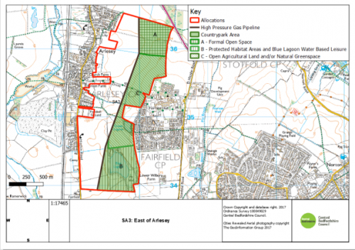
- 2. The eastern edge of the built development shall be defined by the National Grid High Pressure Gas Pipeline to prevent coalescence between Arlesey and Fairfield. No built development, other than that associated with the formal sports and recreation, leisure and agriculture uses, shall be permitted beyond this boundary.
- The development shall provide a country park between the eastern edge of the development and the Settlement Envelope of Fairfield. The country park will comprise a range of different formal and informal typologies to include:
- formal sports provision to the north adjacent to Chase Farm, including associated built development;
- protected habitat areas and enhanced facilities and associated infrastructure to support outdoor and water based leisure uses, including the existing sailing, swimming and diving uses, in and around the Blue Lagoon to the south;
- open agricultural and/or natural greenspace in the central area, around the western boundaries of Fairfield (including the Green Lagoon), to maintain the existing countryside character and prevent coalescence between Fairfield and the development. Within this area there will be no development, other than that appropriate to open countryside.
The extent of the country park and the locations of the individual character areas are defined on the Policies Map.
- The development shall provide an appropriately designed Relief Road to connect Hitchin Road (to the south of Arlesey) to the A507/High Street Link Road in the north being proposed as part of Arlesey Cross. This will allow for access directly onto the A507 relieving congestion along the High Street in Arlesey. The relief road will follow the route of the National Grid High Pressure Gas Pipeline as far as possible.
- The development shall provide dedicated and safe pedestrian and cycle links from the new and existing neighbourhoods to local centres, the country park, Arlesey train station, employment opportunities, schools, shops and community facilities; both within the allocation and the wider Arlesey and Fairfield area.
- The development shall maximise opportunities to create Green Infrastructure corridors and meet the aims and objectives of the Etonbury Green Wheel. This will be achieved through linking the proposed country park on the eastern edge with existing Green Infrastructure assets in Arlesey and Fairfield
Park, including a link with Etonbury Woods; and improving the ecological and biodiversity gains at the Blue and Green Lagoons. - The development shall provide appropriate mitigation, compensation and/or enhancement of key features of biodiversity including but not limited to;
- Blue Lagoon and Green Lagoon; and
- Identified protected species and priority habitats.
-
The development will ensure that any impact on non designated heritage assets with archaeological interest is mitigated in order to record and advance understanding of any heritage assets affected by the development. The mitigation will include making the results of all archaeological investigations publically available for the benefit for this and future generations;The site is in an area with a rich and varied historic environment. Parts of the site are within the setting of designated heritage assets including:- Fairfield Hospital (Grade II listed building);
- The Isolation Hospital at Fairfield (Grade II listed building);
- The Church at Fairfield Hospital (Grade II listed building);
- Church Farmhouse, Arlesey (Grade II listed building);
- Green Farmhouse, Arlesey (Grade II listed building)
The site is also known to contain non-designated heritage assets with archaeological interest.
-
The development will be designed to mitigate any harm caused to the significance of all designated heritage assets in the vicinity of the site. This is required in order to ensure that the public benefits of the development outweigh the any harm caused to the significance of all designated heritage assets affected by the development;;Any future development at this site must ensure it accords with the Historic Environment policies of this Plan (HE1, HE2 and HE3) and the requirements of the NPPF. Any future development proposals will take into account a Heritage Impact Assessment for the site or relevant phase, agreed between the developer and the Council, in consultation with Historic England. The most sensitive to change is Grade II listed Green Farmhouse whose immediate setting still reflects its agricultural past and makes a strong contribution to its significance. Any mitigation measures proposed will be designed to ensure the agrarian character of setting of Green Farmhouse is reflective of the building's original use. Indicative mitigation measures will be identified within the Development Brief, specific mitigation measures will be identified through the Design Coding process. Where preservation in situ of archaeological remains within areas of open space is proposed, any landscaping schemes will be designed to ensure that there is no damage to the heritage assets with archaeological interest.
7. The development shall be designed to preserve all designated heritage assets within the site and shall seek to mitigate the degree of harm to the significance of all designated heritage assets and shall deliver where necessary, relevant and reasonable measures to preserve those assets and their settings for future generations, to ensure the public benefits of development would outweigh the degree of harm to the significance of designated heritage assets.
- The development shall consider the risk of flooding from ordinary watercourses and surface water and shall avoid vulnerable development in these areas accordingly. Subject to the findings of the site specific flood risk assessment the development shall deliver strategic measures to reduce flood risk including the use of sustainable drainage methods (SUDS) in line with Policy CC5.
to attenuate and discharge surface water run-off at reduced rates, and at least at a rate no greater than if the site were undeveloped and to reduce existing downstream risk. This will include consideration of "off-site" solutions on the Pix Brook and River Hiz. The flood risk assessment will consider where surface water from the development will be discharged, in relation to existing flood risks and flood history on the Pix Brook and River Hiz.Regard shall be had to the phased delivery of flood mitigation and SUDS in accordance with the phasing of the development to ensure adequate measures to reduce flood risk (from all sources) are provided throughout the lifetime of the development. The detailed designs of sustainable drainage systems should maximise biodiversity enhancement, mitigation of visual landscape impacts, maintenance and safety, when considering their location and relationship to neighbouring uses. Safe access and egress shall be provided taking account of the flood risk at the site. - The development shall integrate and connect to existing
public rights of waypedestrian and cycle connections within and adjoining the site to provide routes to the wider countryside and neighbouring settlements. Existing rights of way within the site will be upgraded and new routes will be created to Arlesey Train Station in the north, in addition to improving rights of way between the development site and the emerging Arlesey Cross development.
-
It is essential that the development provides an appropriately designed Relief Road to connect the area from the south of Hitchin Road to the A507/High Street Link road in the north being proposed as part of Arlesey Cross. This will allow for access directly onto the A507 relieving congestion along the High Street in Arlesey.
- It is essential that the development integrates and connects to the existing road, cycle and footpath network in Arlesey to allow for permeability and legibility between the new development and Arlesey.
-
The development will be phased in accordance with the timing of supporting infrastructure and community facilities including the delivery of the Relief
rRoad, which shall be delivered as soon as viably possible.
- The development will provide other supporting transport infrastructure, including proposals to mitigate the impact of traffic associated with the development, including providing for efficient public transport routes through the development that link with key destinations including Arlesey, Letchworth and Hitchin Train Stations. The Transport Assessment will additionally need to consider the cumulative impacts of planned development in north Hertfordshire and identify any required mitigation measures. Appropriate contributions will be secured through legal agreements in accordance with Policy HQ2.
-
Foul drainage from the development
willshall be connected to thepublicmains sewerage network. The development shall demonstrate that there is adequate capacity in water recycling centre (sewage treatment works) and the foul sewerage network to serve the proposed development and that it will not have an adverse impact on surface or ground water I n terms of quality and quantity. And any application for planning permission shall detail any infrastructure upgrades where required and any necessary phasing arrangements as agreed by the relevant Water and Sewerage Company.
-
The development shall provide appropriate landscaping measures to create a sense of place, prevent the coalescence of Arlesey and Fairfield, provide a net gain for biodiversity and shall mitigate the potential impact of development on a predominately agricultural landscape.
To mitigate harm a country park will be located on the eastern edge of the development to prevent coalescence and to create a defensible boundary between Arlesey and Fairfield Park. -
The development shall
Iincorporate measures to adapt to climate change, minimise energy use and include renewable energy technologies in accordance with policies CC1, CC2, CC3 and CC5, and any other relevant policies in the Plan.
- The development will be required to respond appropriately to its location within the Health and Safety Executive Major Accident Hazard Pipelines Consultation Zone and identify mitigation measures where necessary.
Justification
To ensure that the policy is effective, justified and consistent with national planning policy
MM36
Para/Policy
SA3
Modification
The map on page 71 of the plan is updated to reflect the suggested change to the site to show which areas must be retained as open agricultural land and which areas shall be used for leisure and/or sports provision. These are shown below:
As submitted:
As proposed for modification:
Justification
MM37
Para/Policy
Section 7.6
Paragraphs 7.8.1, 7.8.2, 7.8.3, 7.8.4
Modification
Insert new Section 7.8
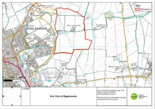
7.8 East of Biggleswade Garden Community
7.8.1 East of Biggleswade is allocated in the Plan (Policy SA4) for a new village scale Garden Community. The site lies to the east of Baden Powell Way and the recent development of Kings Reach, and has been granted Outline Planning Permission for:
- Up to 1500 dwellings,
- Up to 2ha of commercial development, and
- Leisure and community facilities, including a new primary school and 60ha of open space.
7.8.2 In August 2018, the Ministry of Housing, Communities and Local Government (MHCLG) published the 'Garden communities: Prospectus' to support the Garden Communities Programme. The Programme seeks to deliver purpose built, sustainable new settlements or urban extensions that are planned by local authorities and/or the private sector in consultation with the local community and provide:
- a mix of homes including affordable and self build, and job opportunities;
- community infrastructure, schools and health centres;
- communities with a clear identity and an attractive environment, including green spaces and the public realm;
- transport infrastructure, including roads, buses and cycle routes; and
- a plan for long-term stewardship of community assets.
7.8.3 The Prospectus encouraged bids from local authorities and private sector partners for proposals for new gardencommunities, and offered government assistance to help deliver their development. In June 2019 East of Biggleswade was included in Phase 2 of MHCLG's Garden Communities Programme.
7.8.4 Policy SA4 sets out the site specific policy requirements for the East of Biggleswade proposal and any future masterplanning, design coding and planning applications will be expected to demonstrate how the scheme will deliver a sustainable Garden Community.
Justification
MM38
Para/Policy
Policy SA4
Modification
Policy SA4: East of Biggleswade Garden Community
Land to the East of Baden Powell Way, as identified on the Proposal Policies Maps, is allocated for a new, standalone mixed-use development Garden Village consisting of up to approximately 1500 dwellings and associated uses.
Development proposals in the Strategic Land Allocation will be permitted in accordance with other relevant policies in the Development Plan and the where the principles set out below are met. These principles will be defined in more detail through the preparation of a Development Brief which will include a concept plan and an indicative phasing plan. Planning permission will only be granted for development following the Council's adoption endorsement of this Development Brief. A site wide Design Codes will also be required, followed by area specific Design Codes for each phase, to be prepared by the developer and approved by the Council.
In order to ensure the development will be supported by the local and strategic infrastructure needed to ensure sustainable development, in the context of pooling restrictions and multiple landownerships, the Council will refuse any piecemeal planning permission that would undermine the Councils ability to deliver such infrastructure.
The principles of the development are:
1. The development will form a well designed, sustainable Garden Village that will be visibly and physically separate from Biggleswade and will provide a mix of uses necessary to achieve a sustainable and vibrant standalone community, including:
-
in the region ofapproximately 1500 homes with an appropriate balance and mix of residential accommodation to meet identified needs, which shall include subject to viability, a policy compliant mix of affordable housing,starter homes,self/custom build plots and a mix of homes to meet all identified needs for older people; -
provideprovision of a commensurate financial contribution towards the delivery of a health and social care hub to serve the health and social care needs of the development. -
provision of new community facilities in accordance with Policy HQ
23,includinga mix of retail and at least one drinking establishment to serve the existing and new communities everyday needs; - educational facilities, comprising day nurseries, early years, new school(s) for primary aged children to meet the identified needs of the development (or equivalent facilities to meet the educational and childcare needs arising from the development) and financial contributions towards the provision, improvement, enlargement or enhancement of schools for secondary aged children and sixth form facilities off site to meet the identified needs of the development (or equivalent contributions towards projects to meet the educational needs arising from the development) and
- provision of leisure facilities, including:
-
indoor sport and leisure facilities, in accordance with Policy HQ
34; and -
outdoor sport, leisure and open space, in accordance with Policy
iesEE132, including pavilions and allotments.
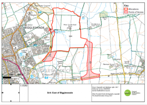
2. The development will provide appropriate vehicular access to the existing highway network. The following access points are identified on the Policies Map, and at least two of these routes will be required to serve the development:
- Baden Powel Way, with a new roundabout at the junction with Frankel Way.
- Baden Powell Way, connecting to the existing roundabout at the junction with Planets Way.
- Baden Powell Way, with a new roundabout between Planets Way and Venus Avenue.
- Dunton Lane, via a new access road and new roundabout.
3. The development will provide dedicated and safe pedestrian and cycle links from the new and existing neighbourhoods to local centres, employment opportunities, schools, shops and community facilities; both within the allocation and the wider area.
4. The development will maximise opportunities to create multi-functional Green Infrastructure, including:
- a parkland corridor to the west of the site to achieve the objectives of the Biggleswade Green Wheel and the provision of public open space as an extension to the Biggleswade Common. This Green Corridor will be of a scale commensurate to the Biggleswade Common with substantial wet woodland planting, rough grassland and scrub, complimentary to Biggleswade Common whilst providing significant mitigation to the inter-visibility between the built development within the allocation site and Biggleswade;
- landscaping and habitat linkages following the northern boundary of the site allocation, extending from the boundary of the site adjoining Biggleswade Common and towards Dunton Fen as well as substantial soft landscaping to be provided along the eastern and southern boundaries of the site to mitigate visual impacts on the landscape and the setting of heritage assets;
5. The development will provide appropriate mitigation, compensation and/or enhancement of key features of biodiversity including but not limited to, identified protected species and priority habitats.
6. The development will ensure that the design and construction of the development as a whole has no undue impact on the landscape and biodiversity and provides for the mitigation and enhancements where feasible.
6. The development will ensure that any impact on non designated heritage assets with archaeological interest is mitigated. The mitigation will include making the results of all archaeological investigations publically available in order to record and advance understanding of any heritage assets affected by the development for benefit for this and future generations;
7. The development will be designed to mitigate the degree of harm to the significance of all designated heritage assets and shall deliver where necessary, relevant and reasonable measures to preserve those assets and their settings for future generations, to ensure the public benefits of development would outweigh the degree of harm to the significance of designated heritage assets;
7. The site is in an area with a rich and varied historic environment and it is known to contain non-designated heritage assets with archaeological interest. Parts of the site are within the wider setting of designated heritage assets including:
- Newton Bury Moat (Scheduled Monument);
- Stratton Moat (Scheduled Monument);
- Sunderland Hall Farmhouse (Grade II listed building)
8. Any future development at this site must ensure it accords with the Historic Environment policies of this Plan (HE1, HE2 and HE3) and the requirements of the NPPF. Specific mitigation measures will be identified through the Design Coding process. Where preservation in situ of archaeological remains within areas of open space is proposed, any landscaping schemes will be designed to ensure that there is no damage to the heritage assets with archaeological interest.
9. The development will be designed to ensure that uses and developments within the site that are vulnerable to flood risk are located beyond areas of flood zones 2 and 3. Safe access and egress shall be provided taking into account flood risk at the site.
10. Subject to the findings of a site specific flood risk assessment the development shall deliver strategic measures to mitigate reduce flood risk including the use of sustainable drainage methods systems (SUDS) to attenuate and discharge surface water run-off at least at a rate no greater than if the site were undeveloped and to reduce existing downstream risk. Regard shall be had to the phased delivery of flood mitigation and Sustainable Urban Drainage Systems (SUDS) in accordance with the phasing of the development to ensure adequate measures to mitigate flood risk (from all sources) are provided throughout the lifetime of the development. The detailed designs of sustainable drainage systems of maximise biodiversity enhancement, mitigation of visual landscape impacts, maintenance and safety, when considering their location and relationship to neighbouring uses;
11. The development will Integrate and connect to existing public rights of way within and adjoining the site to provide routes to the wider countryside and neighbouring settlements. The development shall include pedestrian and cycleway connections to Biggleswade town centre including any highway crossings;
12. The development will be phased in accordance with the timing of supporting infrastructure and community facilities including the delivery of a comprehensive scheme of highway improvement works required to mitigate impacts on road and/or junction capacities;
13. The development will provide other supporting transport infrastructure, including proposals to mitigate the impact of traffic associated with the development, including providing for efficient public transport routes and contribution towards public transport services through the development that link with key destinations including Biggleswade Train Station and Biggleswade town centre;
14. The Transport Assessment will additionally need to consider the cumulative impacts of planned development in northern Hertfordshire and identify any required mitigation measures. Appropriate contributions will be secured through legal agreements in accordance with Policy HQ2.
15. Foul drainage from the development will shall be connected to the mains sewerage network. The development shall demonstrate that there is adequate capacity in water recycling centre (sewage treatment works) and the foul sewerage network to serve the proposed development and that it will not have an adverse impact on surface or ground water in terms of quality and quantity. Any application for planning permission shall detail any infrastructure upgrades where required and any necessary phasing arrangements as agreed by the relevant Water and Sewerage Company;
16. The development will provide appropriate landscaping measures to create a sense of place, provide a net gain for biodiversity and shall mitigate the potential impact of development on the wider landscape.
17. Incorporate measures to adapt to climate change, minimise energy use and include renewable energy technologies in accordance with policies CC1, CC2, CC3 and CC5, and any other relevant policies in the Plan.
Justification
To ensure that the policy is effective, justified and consistent with national planning policy
MM39
Para/Policy
SA4
Modification
The map on page 75 of the plan is updated to reflect the suggested change to the site to show the access points. These are shown below:
As submitted:
As proposed for modification:
Justification
For clarity and Effectiveness
MM40
Para/Policy
SE3
Modification
Policy SE3: A1 Corridor – Holme Farm, Biggleswade
The land designated for Holme Farm, comprising of 78 hectares, incorporating 15 hectares for landscaping, environmental enhancements and sustainable access, as identified on the Proposal Policies Map, will provide new employment floorspace.
Development proposals will be permitted where they:
-
provide for up to
6063 hectares of new employment land comprising up to 38ha of strategic warehousing and up to 25ha of local employment opportunities, including, where appropriate, ancillary uses;comprising
1.1.8ha for a petrol filling station and service uses; and
2. up to 52ha of B2 and B8 floorspace including strategic warehousing;
-
deliver necessary improvements to the A1 and A1 roundabout providing appropriate access to the site;
-
provide a new footbridge and cycleway over the A1 providing access to the services and facilities within the Stratton Park employment and retail area opposite;
-
provide approximately 15 hectares of appropriate landscaping and contribute to the GI network, specifically in relation to the Biggleswade Green Wheel, including improvements to existing footpaths within the allocation providing greater pedestrian and cycle access between Biggleswade and the site via Windermere Drive;
-
provide opportunities for sustainable transport links to be determined through a Transport Assessment, including the provision of shuttle buses to serve the new development, in perpetuity, from the train station at regular intervals during the working week as well as during the weekend;
-
deliver strategic measures to reduce flood risk including the use of SUDS to attenuate and discharge surface water run-off at reduced rates and at least at a rate no greater than if the site were undeveloped and to reduce existing downstream risk. This may include consideration of off-site solutions;
-
do not prejudice the operation of the neighbouring wind farm;
-
Protect mature woodland located within the site from development and enhance it by appropriate, sensitive landscaping;
-
Incorporate the following specific mitigation measures to reduce visual impact and enhance landscaping:
- the retention of Category A and B trees and existing woodland located in the west of the area just outside the site allocation;
- the need to maintain hedgerows where feasible and trees that have biodiversity potential;
- the need to protect species as there are several sets on the site/bats/great crested newts due to the ponds in proximity and ditches;
- the provision of a landscape amenity area and ecological park with water feature;
- character features including a natural woodland edge extending from the existing area of woodland;
- landscape planting using native species;
- a primary green link (centred on the Green Wheel) with improved surfacing connecting to a number of secondary green links which separate the phases of development;
- landscape focal points at the entrance to the scheme;
- boulevard planting along the estate roads and amenity planting along pedestrian routes and around areas of car parking;
- significant landscaping and open space around the southernmost part of the site adjacent to the A1 to provide a transition between the development and the adjoining countryside; and
- a landscape buffer between the A1 to screen views of the development.
-
have maximum building heights of 23m across the site;
-
give appropriate consideration to the topography of the site, with buildings with larger floorplates (and higher eaves) only being permitted on the lower lying land; and
-
give appropriate consideration to roof profiles, colours and materials, alongside opportunities for photovoltaics.
SE3 is in an area with a rich and varied historic environment, it is known to contain heritage assets with archaeological interest. SE3 also lies within the wider setting of designated heritage assets including the Wall and Gate Piers at the Pump House and Pump Masters House, Biggleswade (Grade II listed Building)
Any development at this site must ensure it accords with the Historic Environment policies of this Plan (HE1, HE2 and HE3) and the requirements of the NPPF. Any future development at SE3 must demonstrate that any negative impacts on the significance of the Wall and Gate Piers at the Pump House and Pump Masters House, including through development in their setting, have been avoided and if this is not possible, mitigated. Specific details regarding the siting, scale, colour and massing of the buildings and the landscaping scheme will be agreed through a site-specific Design Code.
A detailed ground water risk assessment will be required to demonstrate no adverse impact from polluting activities on groundwater sources. Proposals will be supported where it can be demonstrated to the satisfaction of the Council, in consultation with the water undertaker, that pollution to existing groundwater sources can be avoided or suitably mitigated.
Development will be permitted in accordance with other relevant policies in the Development Plan and following the successful preparation of a Master plan which provides an exemplar design response to this unique gateway location.
Development of the site should not prejudice the operation of the neighbouring wind farm. Mature woodland located within the site will be protected from development and enhanced by appropriate, sensitive landscaping.
An intrusive field evaluation and appropriate mitigation strategy for multi-period archaeological remains will be required provided before commencement of development. in line with guidance contained within the NPPF.
Justification
To ensure that the policy is effective, justified and consistent with national planning policy
MM41
Para/Policy
SE3
Modification
The map on page 77 of the plan is updated to reflect the suggested change to the site to provide a more comprehensive and cohesive site boundary and improve sustainable access to the site. These are shown below:
As submitted:
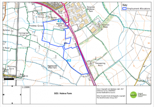
As proposed for modification:
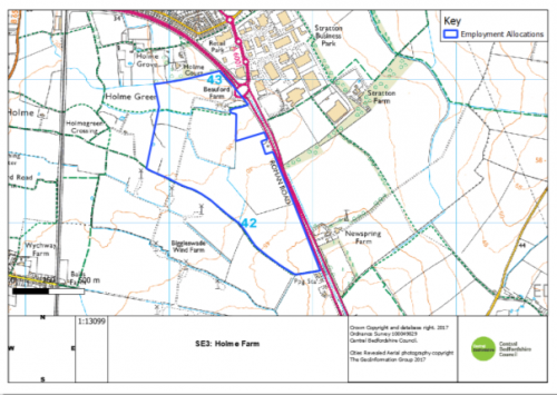
Justification
For clarity and effectiveness
MM42
Para/Policy
SE4
Modification
Delete Policy SE4 and map in their entirety.
Policy SE4: Former RAF Base, Henlow
The former RAF Base at Henlow site as identified on the Proposal Map, will deliver a mixed use redevelopment that will:
- provide for up to 130 hectares of developable land comprising:
- up to 85 hectares of specialist high-technology, science, research and development uses to the north of the A659 Hitchin Road; and
- - a mixed use visitor-economy and residential scheme of up to 45 hectares to the south of the A659 Hitchin Road.
- deliver necessary improvements to the road network maintaining suitable access to the site; and
- provide opportunities for sustainable transport links to be determined through a Transport Assessment.
Due to the nature of neighbouring land uses, all development proposals for this site must have regard to the prevention of major accidents and limiting their consequences, including the increase of vehicular movements on the A600. Development must be designed to maintain appropriate distances between hazardous establishments and populations for the long term to reduce risk.
Development will be permitted in accordance with other relevant policies in the Development Plan and following the successful preparation of a Masterplan which provides an exemplar design response to this unique location.
The quantum of homes to be delivered within the residential element to the south of the A659 Hitchin Road and the redevelopment of existing properties (approximately 500 dwellings in total) will be determined through master planning. These dwellings would be considered as windfall and are therefore excluded from the plan housing target.
Development proposals must ensure the protection of all listed buildings, their setting and important views within the site and take full account of the Safeguarded Zone and transport restrictions associated with established neighbouring uses.
SE4: Former RAF Base, Henlow
Delete the map on page 79 of the plan:
As submitted: to be deleted
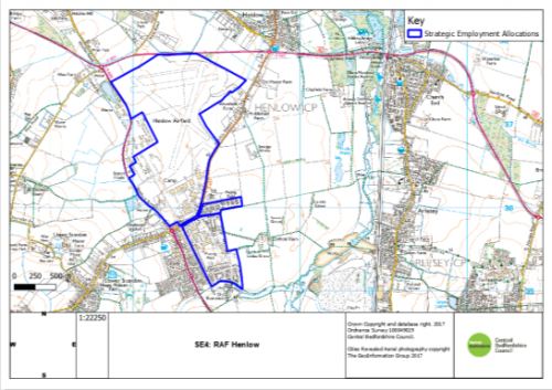
Justification
To ensure that the plan is justified, effective and sound
Chapter 7 (Policy HA1)
MM43
Site/Column
Para 7.8/ Policy HA1
Modification
7.8 9
Policy HA1
Sites identified on the proposals Policies mMaps at Appendix 6 and listed in the table below are allocated for residential development. Allocated sites to be released from the Green Belt that will contribute in part towards meeting the unmet housing need from Luton to 2031 are located at Barton le Clay, Hockliffe, Caddington, Chalton, Harlington and Toddington. These are identified within Policy SP1.
Justification
For clarity and effectiveness
MM44
Site
HA1 HAS01
(Arlesey)
Column
Additional Policy Requirements
Modification
- As there is a single point of access for both sites, development must consider the relationship with site HAS02
Justification
For clarity and effectiveness
MM45
Site
HA1 HAS02
(Arlesey)
Column
Additional Policy Requirements
Modification
- As there is a single point of access for both sites, development must consider the relationship with site HAS01
Justification
For clarity and effectiveness
MM46
Site
HA1 HAS03
(Aspley Guise)
Column
Modification
Remove site allocation in its entirety.
|
|
|
|
|
|
|
|
Justification
To ensure that the plan is justified and sound
MM47
Site
HA1 HAS04
(Barton le Clay)
Column
Modification
Remove site allocation in its entirety.
|
|
|
|
|
|
|
Justification
For effectiveness and to ensure that the site allocations are deliverable
MM48
Site
HA1 HAS05 (Barton le Clay)
Column
Additional Policy Requirements
Modification
-
Provision of a Development Brief in accordance with
required (seeHQ9). - A site-specific FRA.
- A site should be provided to allow the delivery of a new 2FE lower/primary school with appropriate contributions.
- Provide appropriate mitigation/compensation, to ensure potential indirect impacts, such as increased visitor pressure on the nearby Barton Hills NNR/SSSI are avoided or if this is not possible, mitigated.
- Provide appropriate landscape mitigation, in terms of scale and character to protect the setting to and views from Chiltern's AONB. An LVIA will be required to inform the Development Brief.
- Must be integrated with a treed landscape setting to conserve landscape character and views.
Justification
To ensure that the policy is effective, justified and consistent with national planning policy
MM49
Site
HA1 HAS06 (Biggleswade)
Column
Additional Policy Requirements
Modification
-
Will need to implement landscape buffering andMust include appropriate landscape mitigation and GI enhancements north and north east of the site, to protect the landscape and setting of Biggleswade Common and Greensand Ridge escarpment, to create a softer edge to the development.Development Brief required (see HQ9). -
Provision of a Development Brief in accordance with
required (seeHQ9). - A site-specific FRA.
- Need to make an appropriate contribution towards necessary improvements to the level crossing, if required by Network Rail or other relevant authorities.
- Site is within an MSA, a Minerals Resource Assessment will be required.
Justification
To ensure that the policy is effective, justified and consistent with national planning policy
MM50
Site
HA1 HAS07
(Caddington)
Column
Additional Policy Requirements
Modification
- Landscape mitigation required to reduce impact from elevated views and setting to Chilterns AONB.
Justification
To ensure that the policy is effective, justified and consistent with national planning policy
MM51
Site
HA1 HAS08
(Campton)
Column
Additional Policy Requirements
Modification
-
Will need to provide landscaping along eastern boundary of the site, appropriate screening is needed to protect elevated views on the site - Landscape buffer required to southern and eastern site boundaries to mitigate impact on rural setting and views.
- Roadside trees and verge must be retained and enhanced, where possible, to safeguard village character.
Justification
To ensure that the policy is effective, justified and consistent with national planning policy
MM52
Site
HA1 HAS08 (Campton)
Column
Modification
Amend site boundary to reflect correct site area.
0.47 3.67
Justification
To ensure that the plan is justified and sound
MM53
Site
HA1 HAS09
(Chalton)
Column
Modification
Remove site allocation in its entirety.
|
|
|
|
|
|
|
Justification
To ensure that the plan is justified and sound
MM54
Site
HA1 HAS10
(Clifton)
Column
Additional Policy Requirements
Modification
-
Would need to safeguard existing boundary enclosure and trees with new planting and landscaping
Justification
For clarity and effectiveness
MM55
Site
HA1 HAS11
(Cranfield)
Column
Additional Policy Requirements
Modification
-
Site design to incorporate buffering and enhance existing woodland particularly to the eastern edge and along the existing rights of way. - Must be integrated within a treed landscape setting, and linked to enhancement of existing woodland, to conserve landscape character and views.
- Design of the site must be sensitive to the topography of the site particularly in the south-eastern corner.
Justification
For clarity and effectiveness
MM56
Site
HA1 HAS11 (Cranfield)
Column
Modification
Amend site boundary to
2.67 3.89
Justification
To ensure that the plan is justified and sound
MM57
Site
HA1 HAS12 (Cranfield)
Column
Additional Policy Requirements
Modification
-
Existing trees with Tree Preservations Orders must
shouldbe protected.
Justification
For clarity and effectiveness
MM58
Site
HA1 HAS13
(Dunton)
Column
Additional Policy Requirements
Modification
- Site design to incorporate landscape buffering and green infrastructure on the western and northern boundary.
Justification
For clarity, effectiveness and to correct an error as 'northern' should have been included.
MM59
Site
HA1 HAS14 (Eaton Bray)
Column
Additional Policy Requirements
Modification
- A site-specific FRA.
- Must demonstrate the impact of development on the setting of Grade II listed Moor End Farmhouse in terms of significance has been considered and assessed. Where appropriate, applications should show how negative impacts will be avoided or mitigated through detailed design, landscaping and/or other measures.
- Built form must be set back from north-eastern/south-eastern site boundaries with a landscape mitigation of appropriate scale and character to rural edges to protect countryside views to the site.
- Existing hedgerows should be retained and enhanced as part of landscape mitigation.
Justification
For clarity, effectiveness and consistency with national planning policy
MM60
Site
HA1 HAS15 (Everton)
Column
Additional Policy Requirements
Modification
-
Site design
tomust ensurethatthe existing boundary featuresto beare conserved. - Must include provision for the expansion of Everton Heath Primary School.
- Site is within an MSA, a Minerals Resource Assessment will be required.
Justification
For clarity, effectiveness and consistency with national planning policy
MM61
Site
HA1 HAS16
(Everton)
Column
Additional Policy Requirements
Modification
- Must demonstrate the impact of development on the setting of Grade II listed Manor Farmhouse in terms of significance has been considered and assessed. Where appropriate, applications should show how negative impacts will be avoided or mitigated through detailed design, landscaping and/or other measures.
- Landscape screening required to integrate open boundaries and enhance to the road frontage.
Justification
For clarity, effectiveness and consistency with national planning policy
MM62
Site
HA1 HAS17
(Flitwick)
Column
Additional Policy Requirements
Modification
-
Site design to incorporate landscape buffering to Flitwick Wood and the views towards Steppingley. Woodland planting required to strengthen the field boundary to the south-west. Mitigation required due to archaeology from roman period. - Woodland buffer required to north-western and south-western site boundaries to protect open countryside views. This should be of a similar nature to the existing woodland to the south-eastern boundary of the site
- Due to the sites proximity to Flitwick Wood, particular regard must be paid to Policy EE3: Nature Conservation.
- Site is within an MSA, a Minerals Resource Assessment will be required.
Justification
For clarity, effectiveness and consistency with national planning policy
MM63
Site
HA1 HAS18
(Flitwick)
Column
Additional Policy Requirements
Modification
- Explore opportunities for access through adjoining committed developments to achieve better quality design.
- A site-specific FRA.
Justification
For clarity and effectiveness
MM64
Site
HA1 HAS19
(Gravenhurst)
Column
Additional Policy Requirements
Modification
- Landscape buffer required to southern site boundary to mitigate impact on rural setting and views.
Justification
For clarity and effectiveness
MM65
Site
HA1 HAS20
(Harlington)
Column
Additional Policy Requirements
Modification
-
Provision of a Development Brief in accordance with
required (seeHQ9). -
A landscape buffer, incorporating appropriate tree planting, required to reinforce site boundaries and
protect open viewsof an appropriate scale and character to create a new landscape edge to the settlement and form a defensible Green Belt boundary. - Adequate and effective landscape mitigation required across the site to integrate development within views, including any built form on rising ground and up to the eastern site boundary / railway corridor.
-
Noise mitigation
required forto address railway. - A site-specific FRA.
- A site should be provided to allow the delivery of a new 2FE primary school with appropriate contributions. It is expected that the school will operate as a 'lower tier' school in the first instance, but must be capable of operating as a primary school, should this be required in the future.
- Off-site contributions to the Newgrounds Sports Field, in accordance with the Leisure Strategy, in lieu of onsite provision.
-
Improvements to the transport network must be made to enable safe access into the site, and particularly the school, including:
- improvements to footway provision along Toddington Road, including the railway bridge;
- the provision of safe pedestrian crossings and traffic calming measures on Toddington Road;
-
pedestrian and cycle access improvements on Westoning Road;
and - traffic calming along Westoning Road; and
- the provision of appropriate parking in close proximity to the school
Justification
For clarity, effectiveness and consistency with national planning policy
MM66
Site
HA1 HAS21
(Harlington)
Column
Additional Policy Requirements
Modification
- Landscape buffer required to southern site boundary; Design must be complimentary to the AONB setting.
-
Noise mitigation
required forto address railway. -
Existing hedgerows
toshould be retained, buffered and enhanced. - A site-specific FRA.
Justification
For clarity, effectiveness and consistency with national planning policy
MM67
Site
HA1 HAS22
(Haynes)
Column
Additional Policy Requirements
Modification
-
Landscape mitigation required to the south and west,
andboundary hedgerows to the south to be strengthened. - . Appropriate landscape mitigation will be required to conserve the setting of Hill Farm and the Greensand Ridge path
Justification
For clarity, effectiveness and consistency with national planning policy
MM68
Site
HA1 HAS23
(Henlow)
Column
Additional Policy Requirements
Modification
- Noise mitigation will be required for the road.
-
Landscape buffering required
to the wideralong rurallandscapeedge. - A site-specific FRA.
- Must include provision for the expansion of Derwent Lower School
- Due to the nature of neighbouring land uses, all development proposals for this site must have regard to the prevention of major accidents and limiting their consequences, including the increase of vehicular movements on the A600.
Justification
To ensure that the policy is justified and effective
MM69
Site
HA1 HAS24
(Hockliffe)
Column
Modification
Remove site allocation in its entirety.
|
|
|
|
|
|
|
Justification
To ensure that the Plan is justified, effective and consistent with national planning policy
MM70
Site
HA1 HAS25
(Hockliffe)
Column
Approx Capacity and Additional Policy Requirements
Modification
2314
- Landscaping will need to screen and have regard to the nearby scheduled monument to the north
- Noise mitigation will be required for nearby road
- Developers will need to undertake a site-specific FRA which will inform the design and layout of the site including any mitigation.
Justification
MM71
Site
HA1 HAS26
(Hockliffe)
Column
Approx Capacity and Additional Policy Requirements
Modification
41 27
- Landscaping will need to be sensitive to nearby listed buildings and the setting of the Scheduled Monument
- Must include provision for the expansion of Hockliffe Lower School
- Noise mitigation will be required for nearby road
- Developers will need to undertake a site-specific FRA which will inform the design and layout of the site including any mitigation.
Justification
MM72
Site
HA1 HAS27
(Houghton Conquest)
Column
Additional Policy Requirements
Modification
-
Development Brief required (see HQ9) - Site must have regard to the adopted Wixams Masterplan.
- A site-specific FRA.
- Site is within an MSA, a Minerals Resource Assessment will be required.
- Potential for combined impact pressure on Kinds Wood and Glebe Meadows, Houghton Conquest SSSI, with nearby proposed development. Any proposals will need to consider the potential for cumulative impacts and the provision of appropriate and proportionate mitigation which may include the preparation of a joint mitigation strategy, as required.
Justification
For clarity, effectiveness and consistency with national planning policy
MM73
Site
HA1 HAS28
(Houghton Regis)
Column
Additional Policy Requirements
Modification
- Existing trees with TPOs must be protected.
Justification
For clarity and effectiveness
MM74
Site
HA1 HAS29
(Houghton Regis)
Column
Additional Policy Requirements
Modification
-
Provision of a Development Brief in accordance with
required (seeHQ9). - Must incorporate access to HRN1
- A site-specific FRA.
Justification
For clarity, effectiveness and consistency with national planning policy
MM75
Site
HA1 HAS30
(Langford)
Column
Additional Policy Requirements
Modification
- Design will need to be complimentary to adjoining allocation and work with adjacent site developers to ensure the Right of Way to the east of the site is enhanced.
Justification
For clarity and effectiveness
MM76
Site
HA1 HAS31
(Langford)
Column
Additional Policy Requirements
Modification
-
Design will need to be complimentary to adjoining allocation and work with adjacent site developers to ensure
thatthe Right of Way to the west of the site is enhanced. - Landscaping and noise mitigation will be required for the railway edge.
Justification
For clarity and effectiveness
MM77
Site
HA1 HAS32
(Leighton Linslade)
Column
Additional Policy Requirements
Modification
- A site-specific FRA.
- Strategic landscape mitigation required; this must have regard to with the adopted Framework Plan for East of Leighton Buzzard.
Justification
For clarity, effectiveness and consistency with national planning policy
MM78
Site
HA1 HAS33
(Leighton Linslade)
Column
Additional Policy Requirements
Modification
- Site is within MSA, a Minerals Resource Assessment will be required.
- Landscape buffers required to northern and western site boundaries.
- Due to the sites proximity to Linslade Wood, particular regard must be paid to Policy EE3: Nature Conservation.
Justification
For clarity, effectiveness and consistency with national planning policy
MM79
Site
HA1 HAS34
(Leighton Linslade)
Column
Additional Policy Requirements
Modification
- Strategic landscape mitigation required; this must have regard to the adopted Framework Plan for East of Leighton Buzzard.
- Site design to incorporate buffering and enhance the existing woodland.
Justification
For clarity, effectiveness and consistency with national planning policy
MM80
Site
HA1 HAS35
(Marston Moretaine)
Column
Additional Policy Requirements
Modification
- Site is within an MSA, a Minerals Resource Assessment will be required.
- As this site is within the Forest of Marston Vale, particular regard must be paid to Policy EE9: The Forest of Marston Vale.
Justification
For clarity, effectiveness and consistency with national planning policy
MM81
Site
HA1 HAS36 (Maulden)
Column
Approx. Capacity
Modification
-
4525
Justification
Error from earlier versions of plan. Corrected in later versions
MM82
Site
HA1 HAS38
(Maulden)
Column
Additional Policy Requirements
Modification
- A site-specific FRA.
- Site is within an MSA, a Minerals Resource Assessment will be required.
- Landscape mitigation required of appropriate scale and in keeping with the distinct landscape character of the Flit Valley to integrate development within the rural setting and protect views from open countryside to the west.
Justification
For clarity, effectiveness and consistency with national planning policy
MM83
Site
HA1 HAS39
(Meppershall)
Column
Additional Policy Requirements
Modification
- A site-specific FRA.
Justification
For clarity and effectiveness
MM84
Site
HA1 HAS40
(Moggerhanger)
Column
Additional Policy Requirements
Modification
- The site lies within the wider setting of a Registered Park and Garden. Development should demonstrate that the impact on significance of development in the setting of Moggerhanger Park has been considered and assessed. Where appropriate, applications should show how negative impact on significance has been avoided, or will be mitigated through detailed design, landscaping and/or other measures.
- Landscape mitigation required to provide a buffer to the open landscape to the south respecting the distinct character of Park Road.
Justification
To ensure that the policy is effective, justified and consistent with national planning policy
MM85
Site
HA1 HAS41
(Northill)
Column
Additional Policy Requirements
Modification
- A site-specific FRA.
- Development proposals should demonstrate that the setting of Grade II listed No. 39&41 and 43 Thorncote Road has been considered and assessed. Where appropriate, applications should show how negative impact on significance has been avoided or will be mitigated through detailed design, landscaping and/or other measures.
Justification
To ensure that the policy is effective, justified and consistent with national planning policy
MM86
Site
HA1 HAS42
(Northill)
Column
Additional Policy Requirements
Modification
- Landscape scheme required to provide a buffer to open countryside to the north and west.
- Appropriate contributions towards education provision will be required
Justification
For clarity and effectiveness
MM87
Site
HA1 HAS43
(Potton)
Column
Additional Policy Requirements
Modification
- Site is within an MSA, a Minerals Resource Assessment will be required.
Justification
Education point added to all sites in response to discussions at Examination and for clarity
MM88
Site
HA1 HAS44
(Shefford)
Column
Additional Policy Requirements
Modification
- A site should be provided to allow the delivery of a new 2FE lower/primary school unless the need is met elsewhere in Shefford. Appropriate contributions will also be required.
Justification
To ensure that the policy is effective, justified and consistent with national planning policy
MM89
Site
HA1 HAS45
(Shillington)
Column
Additional Policy Requirements
Modification
-
Landscaping
bufferingscheme requiredon the southern boundaryto provide a buffer of an appropriate scale and character to the eastern and southern site boundaries to protect important open countryside views.
Existing landscape / planting features along High Road to be retained and enhanced to provide buffer to Conservation Area.
Justification
To ensure that the policy is effective, justified and consistent with national planning policy
MM90
Site
HA1 HAS45 (Shillington)
Column
Approx. Capacity
Modification
42 15
Justification
Due to site ownership constraints and to ensure that the site is deliverable
MM91
Site
HA1 HAS45 (Shillington)
Column
Site Area (HA)
Modification
2.33 0.63
Justification
For clarity and effectiveness
MM92
Site
Column
Modification
Left intentionally blank.
Justification
MM93
Site
HA1 HAS46
(Lower Stondon)
Column
Additional Policy Requirements
Modification
- Landscape buffering required along northern edge.
- A site-specific FRA.
- Due to the nature of neighbouring land uses, all development proposals for this site must have regard to the prevention of major accidents and limiting their consequences, including the increase of vehicular movements on the A600.
Justification
For clarity and effectiveness
MM94
Site
HA1 HAS48
(Sutton)
Column
Additional Policy Requirements
Modification
- A site-specific FRA.
- Development should demonstrate that the impact on significance of development in the settings of Grade II 37 High Street and Grade II 29-35 High Street listed buildings have been considered and assessed. Where appropriate, applications should show how negative impact on significance has been avoided or will be mitigated through detailed design, landscaping and/or other measures.
-
Design will need to ensure that mature trees and hedges on sites are preserved. - Immediately adjacent to the southern border of the site is a traditional orchard, a Habitat of Principle Importance. Development must not have a negative impact on this asset and should seek to buffer it through careful landscaping.
- Mature trees or hedges on the site should be protected and accommodated within the scheme.
Justification
To ensure that the policy is effective, justified and consistent with national planning policy
MM95
Site
HA1 HAS48 (Sutton)
Column
Approx. Capacity
Site Area (HA)
Modification
37 24
2.04 1.01
Amend site boundary to remove t-shaped woodland
Justification
To ensure that the policy is effective, justified and consistent with national policy.
MM96
Site
HA1 HAS49
(Toddington)
Column
Additional Policy Requirements
Modification
- A site-specific FRA.
- Landscape mitigation including Green Infrastructure enhancement required to south-western site boundary to integrate development and create new landscaped settlement edge.
-
Design expected to include landscape buffering and green infrastructure to the south-western boundary.
Justification
For clarity and effectiveness
MM97
Site
HA1 HAS50
(Toddington)
Column
Additional Policy Requirements
Modification
-
Design should seek opportunities for green infrastructure along western boundary - Landscaping required to western and southern site boundaries to integrate development within wider rural setting and green infrastructure.
Justification
For clarity and effectiveness
MM98
Site
HA1 HAS51
(Westoning)
Column
Additional Policy Requirements
Modification
-
Noise mitigation
required forto address railway. -
AppropriatelandscapingLandscaperequired to protect views to Fltiwickmitigation of appropriate scale and character required to northern, western and eastern site boundaries to integrate development within wider rural setting, to mitigate views and create a new landscaped settlement edge.
Justification
To ensure that the policy is effective, justified and consistent with national planning policy
MM99
Site
HA1 HAS52
(Westoning)
Column
Additional Policy Requirements
Modification
-
Noise mitigation
required forto address railway. - Landscape mitigation required to southern site boundary to integrate development edge.
- A site-specific FRA.
Justification
To ensure that the policy is effective, justified and consistent with national planning policy
Chapter 7 (From 7.9 onwards):
MM100
Para/Policy
Para 7.10.1
Modification
Insert new paragraph before paragraph 7.10.1 as follows:
7.9.1 Houghton Regis North Sites 1 and 2 are existing strategic commitments. The following policy provides a site-specific policy framework to inform decision making on future planning applications. Other relevant policies within this Local Plan will also apply.
Justification
For clarity and effectiveness.
MM101
Para/Policy
Para 7.10.1
Modification
Amend Paragraph 7.10.1 9.2 as follows:
"Houghton Regis North Strategic Allocation Sites 1 and 2 Strategic Commitment
7.10.1 9.2Houghton Regis North Strategic Allocation is a major urban extension on the northern side of Houghton Regis between the A5 and the M1 junction 11a. The Houghton Regis North Strategic Allocation (SA), which sites between the M1 and A5, which will be delivered across two sites although forming a whole. Site 1 comprises the eastern side of the strategic allocation commitment extending from the M1 to the A5120, whilst Site 2 is located to the east of the A5 to the A5120. The A5-M1 strategic link road provides the northern boundary for both sites".
Justification
For clarity and effectiveness
MM102
Para/Policy
Policy SA5
Modification
Amend Policy SA5 as follows:
Policy SA5 SC1: Houghton Regis North Strategic Allocation Sites 1 and 2 Strategic Commitment
Houghton Regis North Sites 1 and 2 are identified on the Policies Map.
All masterplans and planning applications Any development proposals for land within this these designated allocation site areas shall conform have regard to the broad principles outlined within the Council's adopted Framework Plan for North Houghton Regis or the latest adopted amendment to that Framework Plan.
The Green Belt boundary follows the alignment of the A5-M1 Link Road.
Any planning applications for new residential or employment developments on any other land within the Houghton Regis Framework Plan Area red line boundary of sites 1 and 2 shall be considered on a case by case basis and will be required to be accompanied by a comprehensive masterplan which demonstrates an integrated approach to development within the wider context of the site, and shall only be approved planning permission if they are considered to be on balance sustainable as a whole. Other relevant policies within the Local Plan will apply.
Site 1
Site 1 comprises the area between the A5120 and the M1. Masterplans and pPlanning applications will be permitted where they deliver a strategic allocation development that:
-
provides a mix of uses necessary to achieve a sustainable community. These will include:
- approximately 5,150 homes;
- up to 30% affordable homes, subject to viability testing;
- 32 hectares of new employment land in a combination of B1, B2 and B8 Use Classes;
- commercial facilities, including local centres;
- retail units, a foodstore; and a public house;
-
provision
forof early years, primary and secondary educational facilities; - retirement accommodation;
-
community and health centreprovision of community, leisure and health facilities; and - open space and green infrastructure.
- provides opportunities to assist in the regeneration of Houghton Regis through the timely delivery of supporting infrastructure that complements and supports existing facilities;
-
provides the opportunity for long term integration with Site 2 to facilitate the delivery of the wider strategic
allocationdevelopment for this area; -
provides for efficient public transport routes that link with Houghton Regis town centre and the Luton and Dunstable
gGuidedbBusway as well as dedicated and safe pedestrian and cycle links from the new and existing neighbourhoods to local centres, employment opportunities and social and community infrastructure; - provides a green infrastructure network that links, preserves and enhances biodiversity, landscape, heritage, access and open space features within the existing urban area, the strategic allocation and the wider countryside;
- designed to mitigate any harm caused to the significance of all designated heritage assets in the vicinity of the site. This is required in order to ensure that the public benefits of the development outweigh the any harm caused to the significance of all designated heritage assets affected by the development;
- designed to preserve all designated heritage assets within the site and shall seek to mitigate the degree of harm to the significance of all designated heritage assets and shall deliver where necessary, relevant and reasonable measures to preserve those assets and their settings for future generations, to ensure the public benefits of development would outweigh the degree of harm to the significance of designated heritage assets.
- seeks to reduce flood risk along the Houghton Brook and further downstream in Luton by engaging with the Environment Agency to explore practical opportunities that manage flood risk and minimise surface water runoff; and
-
incorporates measures to adapt to climate change, minimise energy use,
mitigates for loss of carbon in soilsand includesrenewable energy technologies in accordance with policies CC1, CC2, CC3 and CC5, and any other relevant policies in the Plan.
Site 2
Site 2 comprises the area from the A5 to the A5120 and extends northwards to the proposed A5-M1 Link Road. The masterplan Planning applications will be permitted where they deliver a strategic allocation development that:
- provides a mix of uses necessary to achieve a sustainable community. These uses will include:
-
approximately
1,500 -1,850 homes; -
up to 30% affordable homes, subject to viability testing
to meet the needs of Central Bedfordshire and Luton residents; - 8 hectares of new employment land in a combination of B1, B2 and B8 Use Classes within the plan period;
- commercial facilities including a local centre;
-
provision
forof early years, primary and secondary education facilitiesincluding sports and playing fields; -
retirement accommodation; - community and health centres provision for community and leisure facilities;
- open space and green infrastructure; and
- potential opportunities for the provision of health facilities.
- provides opportunities to assist in the regeneration of Houghton Regis, through the timely delivery of supporting infrastructure that complement and supports existing facilities;
-
integrates with Site 1 to facilitate the delivery of the wider strategic
allocationdevelopment for this area; - provides for efficient public transport routes that link with Houghton Regis town centre and the guided busway as well as dedicated and safe pedestrian and cycle links from the new and existing neighbourhoods to local centres, employment opportunities and community facilities;
- designed to mitigate any harm caused to the significance of all designated heritage assets in the vicinity of the site. This is required in order to ensure that the public benefits of the development outweigh the any harm caused to the significance of all designated heritage assets affected by the development;
- designed to preserve all designated heritage assets within the site and shall seek to mitigate the degree of harm to the significance of all designated heritage assets and shall deliver where necessary, relevant and reasonable measures to preserve those assets and their settings for future generations, to ensure the public benefits of development would outweigh the degree of harm to the significance of designated heritage assets.
- incorporates measures for the management of multimodal access both within, to and from the site including the mechanisms for their future development and funding through the development of travel plans;
-
provides a green infrastructure network that links, protects and enhances the existing urban area, the strategic allocation and the wider countryside.; in addition contributions will be required to mitigate the impact of development on Houghton Regis Marl Lakes SSSI and Chalk Pit CWS and ensure its long term protection.
and an access strategy that includes the Houghton Regis Marl Lakes SSSi and Chalk Pit CWS. This access strategy and the GI network will be informed by aA detailed ecological assessment which will determine any potential impacts as a result of increased access to the site and all phases will be required to provide an Ecological Enhancement Scheme.; in additioncContributions will be required to mitigate identified impacts of development on the whole site and ensure its long term protection; - seeks to reduce flood risk along the Ouzel Brook by engaging with the Environment Agency to explore practical opportunities that manage flood risk and minimise surface water runoff; and
- incorporates measures to adapt to climate change, minimise energy use and includes renewable energy technologies in accordance with policies CC1, CC2, CC3 and CC5, and any other relevant policies in the Plan.
The Green Belt boundary follows the alignment of the A5-M1 Link Road.
Any planning applications for new residential or employment developments on any other land within the Houghton Regis Framework Plan Area shall be considered on a case by case basis and will be required to be accompanied by a comprehensive masterplan which demonstrates an integrated approach to development within the wider context of the site, and shall only be approved planning permission if they are considered to be on balance sustainable as a whole. Other relevant policies within the Local Plan will apply.
Justification
For clarity, effectiveness and to ensure that the policy is justified


