Proposed Modifications to Policy Maps
9. Changes to settlement envelopes arising from proposed allocations
The following maps illustrate the proposed modifications being made to the Settlement Envelopes in relation to any non-Green Belt settlements resulting from proposed allocations as they appear on the Policies Map.
Modifications to Policy Maps – Allocations in Settlement Envelopes
PM53
Site
HAS01: Land Adj. Lewis Lane
Proposed Modification
Re-drawing of the settlement envelope to include proposed allocation
Inset Map Location
Arlesey
PM53
HAS02: Land Rear of 214-216 High Street
Proposed Modification
Re-drawing of the settlement envelope to include proposed allocation
Inset Map Location
Arlesey
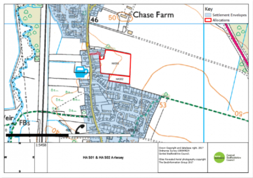
As Submitted
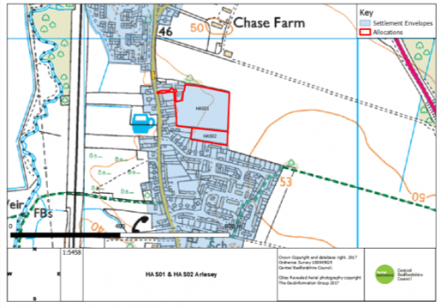
Proposed Modification
PM54
Site
HAS06: Land North of Biggleswade
Proposed Modification
Re-drawing of the settlement envelope to include proposed allocation
Inset Map Location
Biggleswade
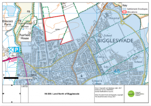
As Submitted
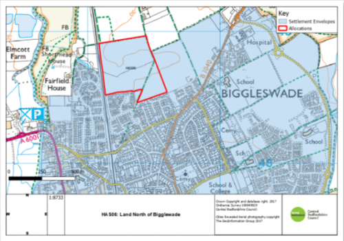
Proposed Modification
PM55
Site
HAS08: Land on South East of the Greenway
Proposed Modification
Re-drawing of the settlement envelope to include proposed allocation
Inset Map Location
Campton & Chicksands
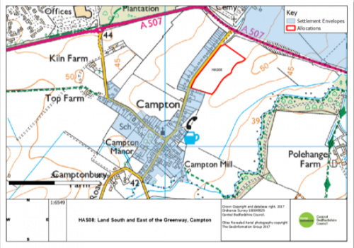
As Submitted
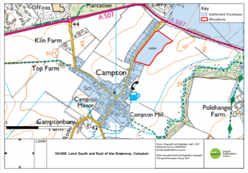
Proposed Modification
PM56
Site
HAS10: New Road
Proposed Modification
Re-drawing of the settlement envelope to include proposed allocation
Inset Map Location
Clifton
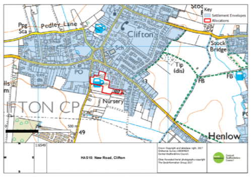
As Submitted
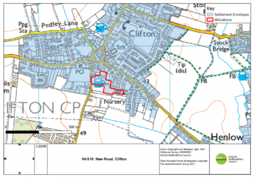
Proposed Modification
PM57
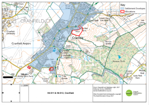
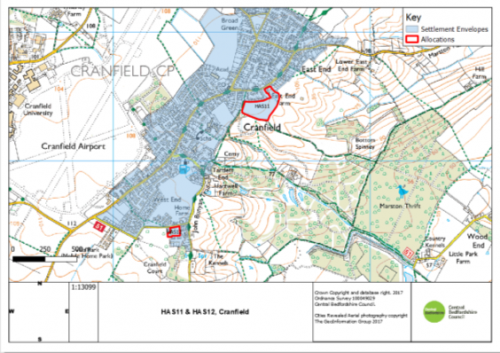
Site
HAS11: East End Farm
Proposed Modification
Re-drawing of the settlement envelope to include proposed allocation
Inset Map Location
Cranfield
PM57
Site
HAS12: Land West of Lodge Road
Proposed Modification
Re-drawing of the settlement envelope to include proposed allocation
Inset Map Location
Cranfield
As Submitted
Proposed Modification
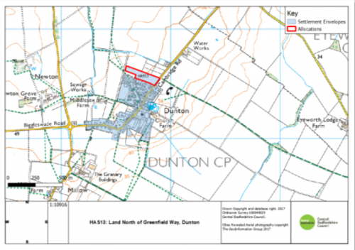
PM58
Site
HAS13: Land North of Greenfield Way
Proposed Modification
Re-drawing of the settlement envelope to include proposed allocation
Inset Map Location
Dunton

As Submitted
Proposed Modification
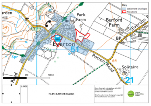
PM59
Site
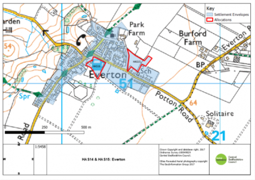
HAS15: Green Lane
Proposed Modification
Re-drawing of the settlement envelope to include proposed allocation
Inset Map Location
Everton
PM59
Site
HAS16: Land at Manor Farm
Proposed Modification
Re-drawing of the settlement envelope to include proposed allocation
Inset Map Location
Everton
As Submitted
Proposed Modification
PM60
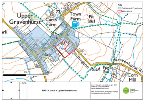
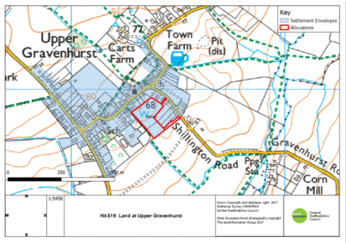
Site
HAS19: Land at Upper Gravenhurst
Proposed Modification
Re-drawing of the settlement envelope to include proposed allocation
Inset Map Location
Upper Gravenhurst
As Submitted
Proposed Modification
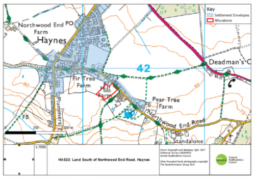
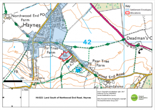
PM61
Site
HAS22: Land South of Northwood End Road
Proposed Modification
Re-drawing of the settlement envelope to include proposed allocation
Inset Map Location
Haynes
As Submitted
Proposed Modification
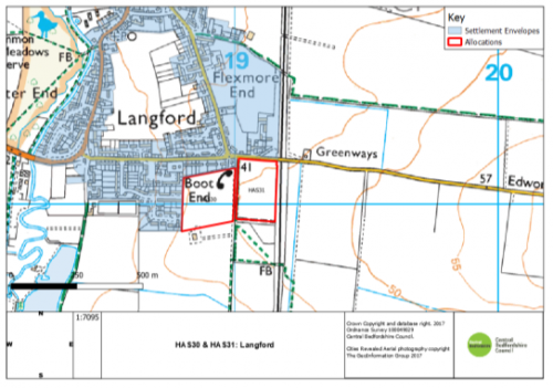
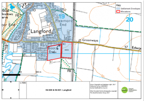
PM62
Site
HAS30: Thistle Hill field
Proposed Modification
Re-drawing of the settlement envelope to include proposed allocation
Inset Map Location
Langford
PM62
HAS31: Bridge Field
Proposed Modification
Re-drawing of the settlement envelope to include proposed allocation
Inset Map Location
Langford
As Submitted
Proposed Modification
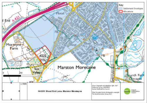
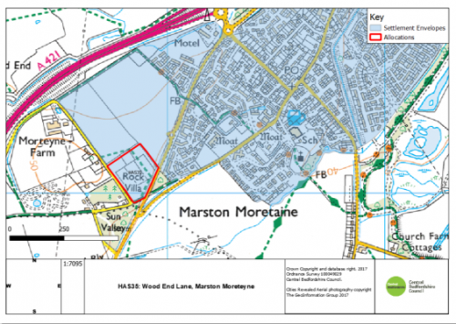
PM63
Site
HAS35: Wood End Lane
Proposed Modification
Re-drawing of the settlement envelope to include proposed allocation
Inset Map Location
Marston Moreteyne
As Submitted
Proposed Modification
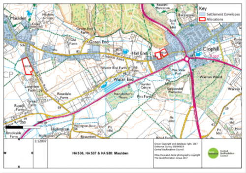
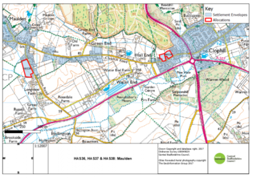
PM64
Site
HAS36: Land North of Clophill Road
Proposed Modification
Re-drawing of the settlement envelope to include proposed allocation
Inset Map Location
Maulden
PM64
HAS37: Land Between 129A and 131 Clophill Road
Proposed Modification
Re-drawing of the settlement envelope to include proposed allocation
Inset Map Location
Maulden
PM64
HAS38: Land Fronting Silsoe Road
Proposed Modification
Re-drawing of the settlement envelope to include proposed allocation
Inset Map Location
Maulden
As Submitted
Proposed Modification
PM65
Site
HAS39: Land at 32 Shefford Road
Proposed Modification
Re-drawing of the settlement envelope to include proposed allocation
Inset Map Location
Meppershall
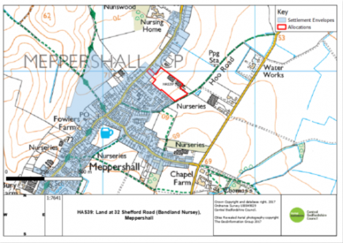
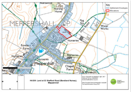
Proposed Modification
PM66
Site
HAS40: Land adj. to Park Road/Bedford Road
Proposed Modification
Re-drawing of the settlement envelope to include proposed allocation
Inset Map Location
Moggerhanger
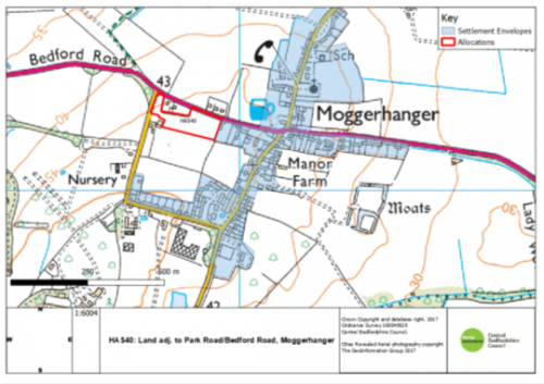
As Submitted

Proposed Modification
PM67
Site
HAS41: Land at Thorncote Road
Proposed Modification
Re-drawing of the settlement envelope to include proposed allocation
Inset Map Location
Northill
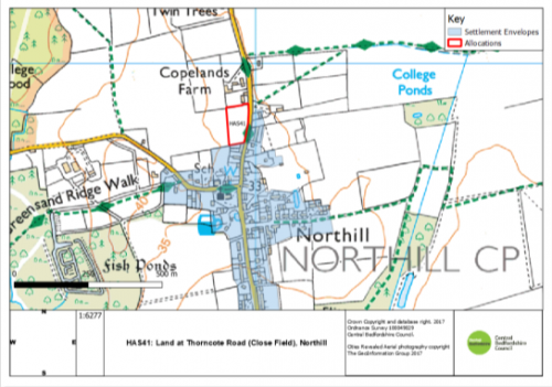
As Submitted
Proposed Modification
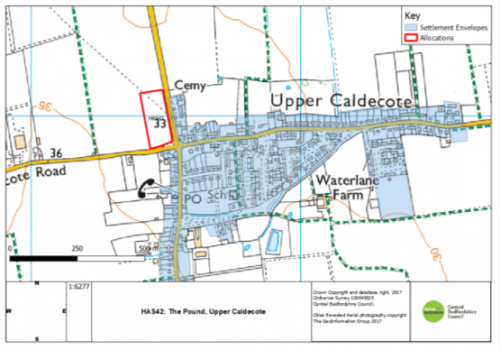
PM68
Site
HAS42: The Pound
Proposed Modification
Re-drawing of the settlement envelope to include proposed allocation
Inset Map Location
Upper Caldecote
As Submitted
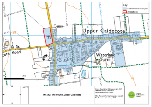
Proposed Modification
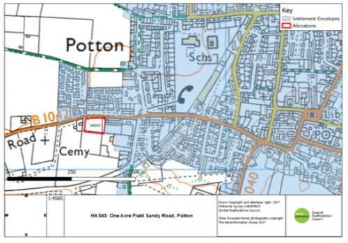
PM69
Site
HAS43: One Acre Field, Sandy Road
Proposed Modification
Re-drawing of the settlement envelope to include proposed allocation
Inset Map Location
Potton
As Submitted
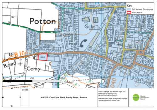
Proposed Modification
PM70
Site
HAS44: Line Field
Proposed Modification
Re-drawing of the settlement envelope to include proposed allocation
Inset Map Location
Shefford
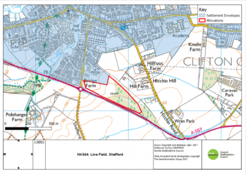
As Submitted
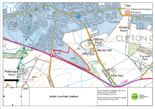
Proposed Modification
PM71
Site
HAS45: Land South and East of High Road
Proposed Modification
Re-drawing of the settlement envelope to include proposed allocation
Inset Map Location
Shillington
As Submitted
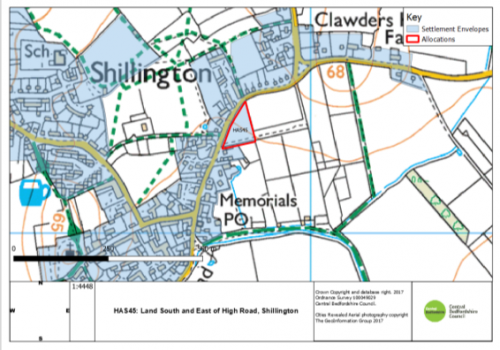
Proposed Modification
PM72
Site
HAS46: Land Rear of Station Road
Proposed Modification
Re-drawing of the settlement envelope to include proposed allocation
Inset Map Location
Lower Stondon
PM72
HAS47: Land off Pastures
Proposed Modification
Re-drawing of the settlement envelope to include proposed allocation
Inset Map Location
Lower Stondon
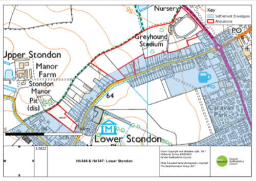
As Submitted
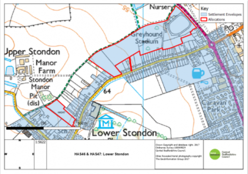
Proposed Modification
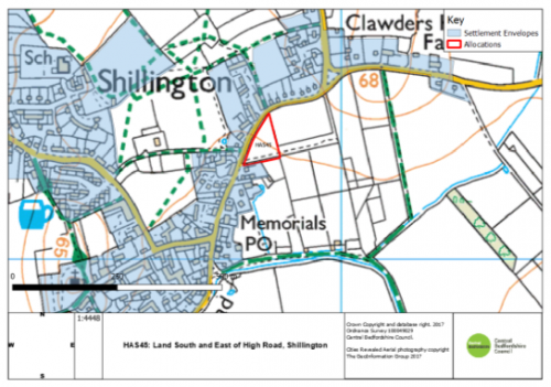
PM73
Site
HAS48: Land South of High Street
Proposed Modification
Re-drawing of the settlement envelope to include proposed allocation
Inset Map Location
Sutton
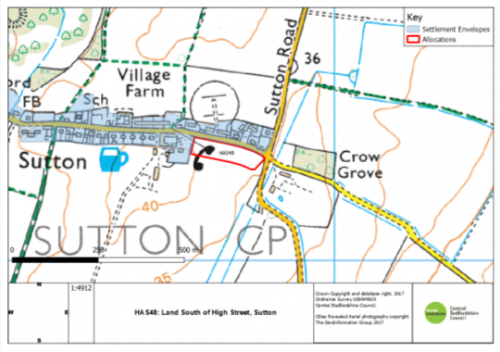
As Submitted
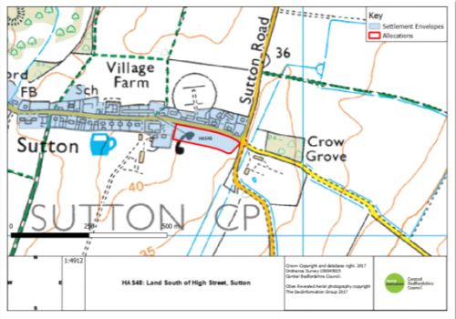
Proposed Modification


